Friday, May 25, 2018

Ingraham Direct Route Conditions - May 23

Looking down the Ingraham Glacier towards Camp Comfort and Gibraltar Rock
The Ingraham Direct is remains the preferred climbing route on the south side of the mountain; it is holding in there even with the recent summer-like temperatures we've been experiencing at Mount Rainier National Park.  Currently, the route is roughly 2.9 miles and is still fairly direct.  Lots of recent rockfall was noticed, especially around Cathedral Gap (see photo).  Once past Ingraham Flats, the route ascends the Ingraham Glacier towards Camp Comfort atop Gibraltar Rock.  From this point, the route switchbacks to Columbia Crest with only one notable crevasse crossing around 13,200'.

With warm weather forecast for Memorial Day Weekend, expect both rock and ice fall on the route.  Crevasse bridges that seem stable on the way up will likely soften throughout the day, increasing chances of crevasse falls on the descent.  Keep a heads up, especially while on your descent.

With the busy weekend right around the corner, please have patience with fellow climbers and know that there will be multiple groups ascending and descending at different speeds.  Please be courteous, communicative, and pass other parties in safe locations.  Also DO NOT split up your team on the upper mountain -- keep everyone roped together while climbing above Camp Muir.  If one person in the group feels like they need to turn around, don't send them down alone.

13,200' crevasse bridge


Recent large rockfall below Cathedral Gap

Cowlitz Glacier and Camp Muir.  Notice the extent of the rockfall crossing the existing track.  We recommend moving through this area quickly and keeping an eye out for falling rock.

Current Ingraham Direct route in orange.

Thursday, May 24, 2018

General Mountain Update

With the busy Memorial Day Weekend approaching, here is a general update of conditions for parts of the mountain.  Climbing rangers are finished with their extensive early season training and will be staffing both Camp Muir and Camp Schurman through this weekend and for most of the remainder of the summer.  If your party is overnighting at either of these high camps expect a briefing from a climbing ranger sometime in the early evening and have your permit information handy.  With the amount of climbers anticipated to be on the mountain this weekend, especially at Camp Muir, count on a busy camp and climbing route and plan accordingly.  Please be patient and courteous with other climbers and NPS employees and hopefully we can all experience a safe and enjoyable weekend on the mountain.

5/23/2018

That being said, here are some details on route conditions.  On Tuesday, 5/22, a team of climbing rangers ascended Sunset Ridge and carried over the summit and down the Ingraham Direct route to Camp Muir.  Rangers found excellent climbing conditions along the way (a detailed blog post on Sunset Ridge coming soon).   Conditions on the upper Mowich Face included 4-6 inches of snow over hard ice.  This allowed for efficient climbing and the option of placing running protection using both pickets and ice screws.  As for skiing on the upper Mowich and Edmunds: this probably isn't the season to do so.  In addition to the blue ice underlying the thin snow-cover, the bergschrund appears to run the full width of the lower Edmunds Headwall and most of the way across the lower Central Mowich Face.  

A view of the Edmunds Headwall from the air - 5/21/2018. 

The main route from Camp Muir is still ascending the Ingraham Direct (ID) route, which is mostly unchanged from the last post, although things are starting to melt out more rapidly with the higher temperatures.  The ID currently has a well-defined boot path and is marked by wands.  Keep in mind that during this time of year the routes see rapid change.  It is certainly possible that in the time of your climb snow bridges could collapse and leave you searching for an alternate route on your descent.  This occurred on Tuesday as a large party of skiers attempting to ski the Fuhrer Finger route were turned around by a collapse of a bridge somewhere near the upper Nisqually Glacier.  They were forced to climb back up and descend the ID instead.  So, at this point, it appears the Fuhrer Finger route may be unskiable from the summit and difficult or impossible to navigate on foot as well.  Your mileage may vary, but these were the reports that rangers received on Tuesday.  First-hand beta from the Kautz Glacier is limited, but upon observation from lower on the mountain it appears that the lower ice pitch on the Kautz is exposed ice while the upper ice pitch is still snow covered.

Upper Nisqually Glacier - 5/23/2018.

The Muir Snowfield, however, is looking very skiable.  Rangers descending on foot on Wednesday, 5/23, were wishing they had skis as they were plunge stepping through smooth corn snow from Muir to about 8,000ft.  This was at approximately 1:00 p.m.  Below 8,000 there hasn't been a consistent overnight freeze so the snow is still a little gloppy.  Most people are now using the approximate summer route to get to the snowfield.  Panorama Point is quickly melting out.  Remember, as the snow melts and exposes ground, it is important to stay on the trail or snow to avoid trampling over the sensitive alpine vegetation.  Also, please remember to watch out for dangerous and thinning snow bridges and holes over creeks and moats throughout the park, especially at and above treeline.  These can be very hazardous and have contributed to fatalities and close-calls in the past. Slow, controlled descents and having a clear visual of the slope help reduce the likelihood of these hazards.
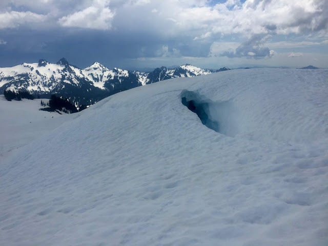
Hazardous snow around Glacier Vista.  

The upper mountain has been seeing a significant amount of skier traffic recently.  While this can be a very rewarding method of travel on Mt. Rainier, it does come with an increased risk.  Lately, rangers have observed some disturbing tactics involving skiers, including parties unroping and separating while some members ski and some walk down with skis on their back, opening them up to an unroped crevasse fall that might not be witnessed by the rest of their party members.  Keep these points in mind if you will be attempting to ski on the upper mountain:  (1) You MUST be a strong skier in all conditions and you MUST NOT fall.  (2) Who is going to carry the rope and how many ropes will you bring?  Will each member of the party carry a rope on the descent, or just the rear skier?  How long is your rope?  Will it reach the bottom of a crevasse if your buddy falls in while skiing?  (3) If one of your party members decides that skiing is above their ability level, it is a good idea that the whole team join them in putting the rope back on and walking down together.  (4) You CAN walk back down, roped-up, if conditions are not favorable to skiing.  That is the safer option.

Lastly, the Paradise Wilderness Information Center (formerly the Climbing Information Center) is now open daily for the summer.  You must register for your climb in person - there is no more self-registration for the season.  The PWIC is open from 7:00 a.m. to 4:00 p.m. Enjoy the sunshine and be safe out there!


Friday, May 18, 2018

White River Road is Open

Liberty Ridge on May 7, 2018
As of May 17, 2018 the White River Road is now open to the campground and trailhead! The road remains closed beyond this point and is snow-covered to Sunrise.

Climbers attempting the Emmons Glacier or other routes on this side of the mountain should come prepared for difficult travel conditions getting to Glacier Basin. There are no established routes on the upper mountain. Be equipped and proficient with a GPS and a map & compass for off-trail navigation.

The weather is looking quite unsettled for the next few days. This will lead to challenging conditions on the upper mountain with cloud cover, snowfall, and cooler temperatures than have been experienced recently. Spring conditions have returned to the upper mountain.

Thursday, May 17, 2018

Route Update: Ingraham Direct and Gibraltar Ledges


On Wednesday, May 16th, climbing rangers ascended the Gibraltar Ledges route from Camp Muir and descended via the Ingraham Direct.  Mild temperatures and minimal wind made for good climbing conditions, even though visitors at Paradise saw only glimpses of the mountain through the marine layer clouds.  The standard route from Camp Muir ascends to Ingraham Flats, then continues straight up the Ingraham Glacier and upper Nisqually Glacier to the crater rim.

The Ingraham Direct route from Camp Muir.  
The most heavily crevassed area on the route is between 11,500 and 11,800 feet on the Ingraham Glacier.  Remember to keep the rope tight between you and your partners when crossing crevasses over snow bridges.  At 12,200 feet, the route trends climber's left towards the top of Gibraltar Rock and Camp Comfort.  From there, the route follows a fairly direct path, occasionally end-running larger crevasses on the upper glacier.

Descending above Ingraham Flats.
The guide services have marked the route well with wands.  Disappointment Cleaver collected a lot of snow last winter (right side of photo above) but there is currently no boot pack going up the Cleaver.

Rangers found decent climbing conditions on the ascent up Gib Ledges.  The route is still mostly snow covered at this time, although several sections of loose rock exist.  Be aware of rockfall and move quickly under Gibraltar Rock.  The snow on the ledges was quite firm, with a little verglas; necessitating careful cramponing.

Gibraltar Ledges
If you plan on climbing this weekend, be sure to check the Mt. Rainier Recreational Forecast.  A dynamic weather pattern will persist through the weekend and into next week.  Be sure to carry a GPS and be proficient with navigation in the event that weather deteriorates during your climb or the trip to high camp.  The Paradise Wilderness Information Center (formerly the Climbing Information Center) is open this weekend and issuing climbing permits--stop by before heading up the mountain. Climb safe and have fun!

Wednesday, May 09, 2018

Spring Route Update - May 9, 2018

This picture shows the upper section of the Central Mowich Face in the foreground. The Sunset Amphitheater ridge line connects the Mowich Face to the Tahoma Glacier in the background.
Climbing Rangers have been out training on the mountain with the military over the past few days. Good weather provided the opportunity to get more early season photos of the upper mountain. These photos were taken May 7th, 2018. Remember that conditions change frequently this time of year. Snow coverage and surface conditions in these photos could be different.

Concessionaire guiding operations began this week on the Disappointment Cleaver route. The route currently ascends the Ingraham Glacier Direct and traverses over to Camp Comfort atop Gibraltar Rock before going to the summit. Conditions on the Ingraham Glacier are dynamic and this route often falls out of condition quickly.

Disappointment Cleaver
Other notable observations included large crevasses opening on the Carbon Glacier, and a large crevasse forming on the Emmons Glacier around 12,500'. The Kautz Glacier sports bare ice on both of the ice steps above Camp Hazard.

The extended weather forecast for this weekend is calling for a high pressure system to move in starting on Friday with sunny days over the weekend. Warm temperatures have also been producing natural, wet loose avalanches on many slopes--particularly those exposed to strong solar radiation. Beware of wet surface snow, deep boot penetration, exposure to large slopes, and cornices lurking above. Finally, expect to see other parties if you're climbing one of the more popular routes.

Emmons-Winthrop Glacier
Liberty Ridge, Carbon Glacier

Tuesday, May 01, 2018

Mount Rainier Announces Projected Road Opening Dates

Construction and snow delays reopening of Chinook and Cayuse passes
Mount Rainier National Park announces that sections of State Route 410 and State Route 123 between the Sunrise Road and the Stevens Canyon Road, to include Cayuse and Chinook passes, will experience a delayed opening as a result of spring snow conditions and a significant construction project. The expected opening of both SR 410 Chinook Pass and SR 123 Cayuse Pass is June 11.
Contractors will begin work on April 30 to repair a quarter mile of SR 410 near milepost 64 along the Mather Parkway in Mount Rainier National Park. For several years, motorists have experienced rough road surfaces at this location related to a slow moving and deep-seated landside.
Due to the extensive nature of the work to be completed during a short construction window and additional heavy snowfall this spring, SR 410 will remain closed just south of the junction with the Sunrise Road near White River, and SR 123 will also remain closed at the Stevens Canyon Road junction.
This road repair project was timed to have the least impact possible on the traveling public with the work beginning before the road typically reopens in the spring. Following the anticipated June 11 road reopening, project work will continue until late June. During that time travelers should expect short delays with alternating one-way traffic between mileposts 64 and 64.5.
“For generations, the Mather Parkway has provided access to scenic vistas and recreational opportunities within Mount Rainier National Park,” said Chip Jenkins, park Superintendent. “This important investment in our roadways will stabilize the road, preserve a historic roadway, and improve the safety for the travelling public.”
 Mount Rainier National Park is targeting May 11 to open the park’s southeast entrance near Packwood, providing access via SR 123 to the Grove of the Patriarchs area. Portable restrooms will be placed at the Grove parking area until the primary restrooms are opened for the season.
The northeast entrance to Mount Rainier National Park near Enumclaw is expected to open onMay 18, with access via SR 410 from the park entrance near Crystal Mountain Boulevard to the White River Campground parking lot. This will provide recreational opportunities in the White River area of the park in advance of the road to Sunrise opening for the summer. Conditions permitting, the road to Sunrise typically opens by the July 4th weekend.
Park information, announcements, and the Mount Rainier webcams are available on the park’s official website www.nps.gov/mora.  Learn about the park by joining the Mount Rainier community on Facebook facebook.com/MountRainierNPS or on Tumblr mountrainiernps.tumblr.com/; find out breaking news and road status updates through Mount Rainier's Twitter feedtwitter.com/MountRainierNPS; explore the park and behind-the-scenes operations with our videos on YouTube youtube.com/MountRainierNPS; and share your own photos of Mount Rainier onInstagram @MountRainierNPS or in the Mount Rainier Flickr groupflickr.com/groups/MountRainierNPS.