Wednesday, August 23, 2023

DC Update 8/22/23

Looking across the Cowlitz Glacier from Camp Muir with some smoke haze in the air. (8/22/23)

August is quickly coming to a close, and we are back to discuss the condition of the DC after the heatwave in the past week or so. The aftermath, if you will. If you haven't gotten the chance to check out what was happening to the mountain during this prolonged period of elevated temperatures, check out:

Route Overview:
With 17,000'+ freezing levels, the small and thinning snow and ice features that the route utilized to reach the summit in our 8/8/23 DC update have suffered significantly. Portions of the route have collapsed, and other cruxes have become so difficult to surmount that some guide services have officially ended their seasons taking clients to the summit. As we anticipated, the high temperatures then subsequent cool off have led to firm, icy surfaces on many parts of the mountain, resulting in slide-for-life conditions where arresting a fall would be difficult.

It is important to understand that while one can still climb the Disappointment Cleaver route in it's current condition -- at the time of this post -- to the top of the mountain, that there is no longer a maintained "route" that many climbers have come to expect. In most places, there is no bootpack, no wands, nor any ladders to lead to you to the summit. Ladders and route adjuncts above the cleaver were all going to be pulled by today 8/22/23.  Old routes may be apparent but are NOT maintained.  Be prepared for steep and exposed conditions that demand advanced glacier navigation, discretion of hanging or unsupported features, evaluating bridges and plugs, and potentially more involved glacial travel techniques such as rappelling into and needing to ice-climb out of crevasses to cross them.

If you do believe you and your teammates possess these skills, plan on navigation taking a significantly more time than any other ascents of the Disappointment Cleaver. Plan on at least a handful of attempts to bypass obstacles that will end in needing to turn around to try a different option. All recreational climbers that rangers interacted with at Camp Muir did not go past Ingraham Flats this past week. To put it simply, the objective hazards on the route are currently just much higher than other times of year.

Wildfire Smoke Complications:

Looking down towards Paradise from Camp Muir in unhealthy smoke conditions.  Normally, you would be able to see the whole Tatoosh Range, as well as Mt. St. Helens, Mt. Adams, and Mt. Hood. (8/21/23)

In addition to the difficulty and character of the route changing since the heatwave, there are a number of fires that are plaguing the Northwest air quality at the moment. If you live in-state this won't be any surprise, however if you're coming from out of town, know that the AQI (Air Quality Index) has been in the unhealthy range many days in the past week. While the fires still carry on, wind direction / atmospheric flow plays a huge role in if the smoke reaches Mt. Rainier. For the most up to date information, check out these air quality / wildfire resources:
  • AirNow Fire and Smoke Map is a government resource where you can input any location in the U.S. and see a map of current air quality readings at monitoring sites as well as active fires. If you click on a location, some even have smoke forecasts, letting you know if experts in atmospheric flow believe the smoke will improve or worsen in your location of interest. How cool! The closest one to Camp Muir is at the Jackson Visitor Center at Paradise.

  • Mt Rainier Webcams is a site with links to webcams all over the park, including at Camp Muir and Paradise. Curious if high camp is above the smoke, or if Paradise is socked in? This is a great place to check. 

  • InciWeb is a great resource to see the most up-to-date details on wildfires in the U.S. Similar to the AirNow platform, there is an interactive map of incidents. If you click on an incident, you can find out what percentage the fire is contained, size in acreage, types and amount of resources dedicated to the incident, along with fire behavior and a lot of other information. This can be a helpful map to look at if you're trying to brainstorm a plan B for Rainier, and find out how the fires that are causing the smoke are developing. 

Feature to Feature Updates:
  • The Cowlitz: Similar to our last complete route update, this section of the route continues to be threatened by overhead rockfall from Gibraltar and Cathedral Rocks, ever-thinning snow bridges, and widening crevasses. There are some cracks opening up less than 8 feet away from where you leave the dirt at Camp Muir, so be sure to rope up before leaving camp. And -- evaluate your campsite selection wisely if choosing to camp on the snow! Some commonly used sites are now sitting a top thin snow bridges on the Wind Roll. 

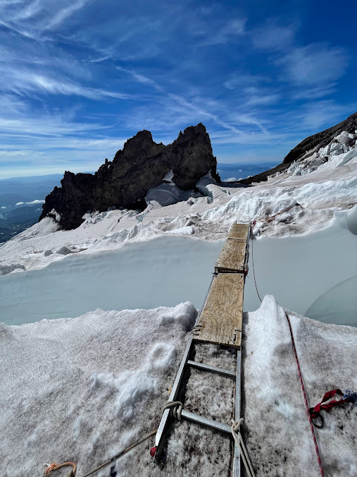
    Note the cracks opening up on the Cowlitz Glacier. (8/20/23)

  • High Crack (11,300'): High crack -- the first notable feature when climbing up past Ingraham Flats -- still has a ladder to grant passage across it at this time. A popular alternative for many climbing parties who are not prepared for the high hazard route finding higher on the mountain is to opt to climb from Camp Muir, across the Cowlitz, up through Ingraham Flats, to High Crack and turn around. Some want the ladder crossing practice, but will spin just on the other side, to avoid entering the higher hazard portions of the Ice Box and Bowling Alley. This is an excellent alternative if you want to climb, get some glacial navigation and ladder crossing skills practiced, but do not want to undertake the more complex and severe hazards higher on the route.

  • Getting onto the Cleaver: The unprotectable traverse to gain the Disappointment Cleaver from the glacier as of 8/8 relied on "a narrow section of ice, that then gains the cleaver on some quickly melting, and thin, small snow and ice features". These features have since collapsed. While there is a way to navigate on top of the smashed remains of this traverse to gain the cleaver, these new features remain vulnerable to further collapse. There is running water beneath the remains of these features, and it would be a high likelihood, high consequence event for this traverse to further collapse. Be sure to understand the risks you are taking before you embark across this section, knowing it must also support you returning to camp later in the day.

  • Above the Cleaver: There is no established route that will get you to the summit of Mt. Rainier from the top of the Disappointment Cleaver. As described earlier in this post, know that advanced glacial travel techniques and a significant amount of experience are needed to continue further up the mountain from this point. Route adjuncts have been removed beyond this point as of 8/22/23.

Looking Forward:
While there is still traffic heading up and down the mountain in various forms, the climbing season is certainly winding down. A light dusting of snow coated Camp Muir on the morning of 8/23 -- telling us of the changing of seasons that is ahead. If you're planning on a hike up to Camp Muir, remember to check the latest blog on the changing conditions on the Muir Snowfield. That's what we have for now, folks! See you up there.

The sun makes it's debut from behind Muir Rocks on the morning of 8/23/23 after a light dusting of snow fell atop Camp Muir.


Wednesday, August 16, 2023

Upper Mountain Conditions 8/16/2023

The 17,000+ foot freezing levels we've had over the last few days have had quite the impact on Mount Rainier and its glaciers. Things have been changing drastically from one day to the next (or hour by hour) with how fast things are melting. This puts climbers at a higher level of risk than normal and requires a lot of prior experience on glaciers and climbing to have the skillset for managing the risks and route navigation decisions.  Again, these HOT temperatures are making conditions DIFFICULT for climbers.

The traverse across the Cowlitz Glacier has been changing day by day as guide groups have made edits to the route as crevasses rapidly open up in the bootpack and rockfall threats above change fall lines. A number of people have punched into some crevasses, surprised to fine the "track" went over an overhanging snow bridge that was not obvious before.  No climber "plans" on falling in a crevasse, so please come prepared on these HOT days to do actual crevasse rescue.  

The double ladder at high crack at the moment is still in place and folks can still traverse onto the Cleaver, but the plug that connects to the cleaver had water running underneath it and has a big overhang, so if it were to collapse in these HOT temperatures it would not be good.  

Looking at the traverse onto the DC on 8/14/2023

Above the cleaver, the snow is isothermic, or "punchy" and not very supportable. There have been reports of folks falling into crevasses unexpectedly here too. The double ladder at 12,800' was still in place as of August 16th, but from here, folks can plan on finding their own route. On August 15th, the guides pulled the triple ladder spanning the 12,900' crack because it was sitting on overhangs that weren't reliable.  No parties have summited the DC Route for the last couple of days due to crevasses not being safe to cross.  


Upper Thousand plus feet of the DC Route. 8/14/2023

Parties that want to find their way to the summit via the DC Route will have to do some extreme end-running of crevasses or rappel into and ascend out of crevasses.  And, at the moment, you will need to find your own route, accept a relatively high level of risk for this route, and have extensive glacier and climbing experience.  Recognize that crevasses may fail any time during the day, sometimes behind you, leaving your party to discover they can't descend via the route they came up.

Another view of the upper couple thousand feet of the mountain. 8/14/2023

Luckily there is an end to this heat in sight. Temperatures look like they may plummet to about 9000' freezing levels by Sunday. After these warm temperatures however, such cold conditions will likely present challenging conditions in a different way - all this glacial melt could solidify making for icy and unforgiving surfaces. Having sharp, steel crampons on full shank boots and sure footing with them will be essential to help you manage this upcoming drastic change in conditions.

Looking at Camp Schurman and the Emmons-Winthrop on 8/14/23

While this all sounds a bit dire, there's still some great vistas, cooler temps, and great opportunities to practice mountaineering skills around both high camps on the mountain.  The stars and meteor showers have been all-time.  Just don't plan on a typical "summit climb" adventure right now.  See you on the mountain!

Looking above the Cleaver. 8/14/23

View near the Emmons shoulder and the 12,900 crack. 8/14/23


Thursday, August 10, 2023

DC Route Update 8/8/23


Looking up through the sea of penitentes towards the ice headwall from just above the cleaver. 8/8/23

It's August on Mt. Rainier and there's no two ways about it! With a number of successful summits, and an almost even number of parties spinning due to conditional challenges and inclement weather, the mountain is telling us it's starting to wind down for the season. 


View down towards the top of the Disappointment Cleaver itself. Note the faint trail through the penitente and light fresh dusting of snow. Precipitation has come on the upper mountain without being in some forecasts lately. 8/8/23

Route Overview:
The route as it stands is long and circuitous — it is currently 3.4 miles with 4000' of elevation gain coming from Camp Muir just to the summit crater. That's about a 7 mile round trip adventure at altitude high camp to high camp. If you've climbed the DC earlier in the season, this will not be the same type of experience. Be prepared to go up to go down, and down to go up! Due to weaving between the many large crevasses, you'll find yourself losing and regaining elevation a number of times on the ascent and descent. While the route has a boot pack in place along with wands from guide services, these navigational aids are not enough to climb the route. With new precipitation and high winds as experienced this past weekend, the bootpack can become less obvious and covered with new snow, and wands blown down. There are also older junctions from different iterations of the route that can throw one off when navigating down in low visibility conditions if you do not have a track from your ascent to follow. Be sure to have some sort of personal GPS software downloaded on your phone (ex:CalTopo, Gaia, FatMap, etc. all have free versions with this function) and start tracking as soon as you leave Camp Muir. This way if you find yourself in a whiteout on your descent, you will have a path to follow even with low visibility! See it as cheap insurance that could save your life, if not save you from an epic descent in miserable conditions.


A screenshot of the route tracked from Camp Muir to the summit crater climbed on 8/8/23 with Gaia GPS. Travel to the true summit then back to the crater rim will take quite a bit of additional time.


Feature to Feature Updates (in order climbing from Muir to Summit):
  • The Cowlitz: Leaving Camp Muir, the Cowlitz Glacier is opening up quite a bit with some sizable crevasses. There is a significant one just before the transition to the rocks below Cathedral Gap that in higher snow years does not open up. The traverse is now lower to avoid this, gaining the rocks below the crack. Know that as soon as you're leaving camp,  you're stepping out onto a real glacier with real crevasse fall potential. Additionally, there is quite high objective overhead rockfall hazard from Gibraltar and Cathedral rocks when crossing the Cowlitz, so be sure to move through this terrain efficiently.

  • High Crack (~11,300'): As you climb out of Ingraham Flats, the first notable feature you come to before entering the Ice Box and Bowling Alley is a very large longitudinal crevasse, or crack that runs up and down on the mountain (glacial anatomy typically causes glaciers to have cross-slope crevasses, as the ice is stretched out over rolls on the hill side). This vertical crevasse is often referred to as "High Crack", and here is the first ladder crossing of the route. After this, you move into the Ice Box and Bowling Alley, named for their overhead hazards. Move through these efficiently as well.

  • Getting onto the Cleaver: Due to high temperatures and the lower snow year, the transition from the glacier to get onto the cleaver has been an issue this year, and continues to be one of the condition-dependent navigational cruxes of the route. In the two or so weeks, there has been a reroute across a narrow section of ice, that then gains the cleaver on some quickly melting, and thin, small snow and ice features. This traverse is vulnerable to the incoming high temperatures and will pose more and more of a challenge as the season continues on. There is not currently a good way to protect this traverse. The cleaver itself is free of snow.

  • Traverse out to the Emmons Shoulder (~12,800'): There were 3 route adjuncts, or pieces of equipment that are in place to provide easier travel, above the Cleaver on 8/8/23. Consistent with our update a little more than a week ago, there is one adjunct in the form of a ladder crossing at 12,800' right before the traverse begins. Following this, there is a single plank to cross a widening smaller crack. Then, there is another series of three ladders latched together to cross a matrix of cathedraled cracks at 12,900' which has gotten significantly more hollow and undercut since our last update. Look at the comparison photos below to see just how much a glacier can change in two weeks late in the season! As with any fixed gear on the route, while the guide services place these adjuncts, it is not their job to guarantee that they are safe for you to use — only their clients. Adjunct stability can change throughout the day. This means that before crossing any adjunct, be sure to evaluate the structural integrity of what they are placed on. If you do not think it's safe, do not use it! Your safety is in your hands, not on the guide services. 


Initial ladder crossing above the Cleaver near 12,800' on the descent. (8/8/23)

       
The single plank crossing between 12,800' and 12,900' (8/8/23)

The 12,900' triple ladder crossing as of 8/8/23. Note the undercut and "cathedraled" nature of the bridge across the crack.


The same ladder crossing at 12,900' on 7/23/23, just two weeks prior. Notice the significantly higher amount of snow and ice present than in the last photo.


Other considerations:
There have been a handful of fixed protection pieces on the route to clip into on more exposed sections above the Cleaver in the form of pickets placed by guide services. If you bring your own alpine draws (sling with two carabiners) you can utilize these pieces, however know that it is your responsibility to evaluate if these pickets are still safe to trust. Feel free to reset them if they are melting out, but don't move or take them. The number of pieces of fixed pro on the upper mountain has been fluctuating, so there may be none there when you climb. 

Looking forward:
The weather forecast — which has had varying levels of accuracy in the past few weeks — through the weekend tells us one thing: hot, hot, hot! This can affect the route, and route adjuncts, drastically as the mountain changes. The mountain is most alive this late in the season, and expect a dynamic environment up there. Have fun, be safe, leave camp early, and return early in the day with time to enjoy an afternoon nap before descending! That's the DC as of 8/8/23 folks. See you up on the mountain!


Muir Snowfield Update 8/9/23

Blue Ice, crevasses, and warm temperatures oh my! The Muir Snowfield is becoming more of an "Icefield" than a snowfield.  There is exposed glacial ice with a number of crevasses beginning to open up above 8500'. Where there is snow, the surface conditions are quite sun cupped and coated with a fine layer of rock and dust. These hazards will only progress with our forecasted hot temperatures over the next week. 

~8in Wide Crevasse at 9,600ft 

The crevasses that are present on the upper portion of the snowfield are relatively easy to spot and navigate around, but caution should still be taken as the surface condition adjacent to these features are firm and icy. Take caution while descending from Camp Muir, as a couple of these cracks can be difficult to spot from above.

A Snowbridge someone punched through adjacent to a worn boot pack

While navigating the Snowfield, we recommend appropriate sturdy boots that are capable of accepting micro spikes or even crampons! Devices like these that add traction on the snow and ice greatly add security. Trekking poles are also recommended to aid in hiking on this variable and often slick terrain. 

Looking Down the Snowfield

Finally, having and knowing how to use GPS devices/applications is essential to aid in navigating on the snowfield. It is exceptionally common to find yourself in whiteout conditions and these modern tools can be a literal lifesaver.

Friday, August 04, 2023

The Kautz 8/2/2023

Climbing Rangers got on the ice pitches of the Kautz on Wednesday and they are in excellent condition. Even if you don't go or make it to the summit, the ice pitches of the Kautz can be an excellent outing to sneak in some ice climbing in August and September.

The Rangers took the Wilson Gulley to approach the Castle. Be sure to move through the rock fall hazard efficiently if you choose to go this way. It may not be an option much longer this season. The fan has been completely melted out for a while now. Consider the Comet Falls to Van Trump approach; you gain more elevation this way, but it's more of a hike and has no overhead hazard. 

Wilson Gulley to Wilson Bench on Tuesday 8/1/23

There is heaps of water flowing at the Castle bivy sites and some at the upper bivies before the rock step, at least from the heat of the day to the evening. Rangers did find a number of abandoned blue bags around the bivy sites that they had to carry down. Please remember to carry out your human waste to help keep these sites and the water source clean.

The rock step was about as easy at it gets this time of year, but once a small patch snow at the bottom melts away, it will present a more significant and challenging down climb. Even now we would still recommend setting up a belay for the descent and ascent out of there for the move to step off the rock is quite exposed. 

Looking from the bottom of the Rock Step at the Kautz Ice pitches and the traverse over to the base 8/2/23

The traverse onto the Kautz did not have as many hanging seracs as it has had in the past, but that will likely change soon and it would still be good to move efficiently through here as you will see from signs of recent rock fall. Check the moat as you move off the rock onto the Glacier for this could present a hazard as well. The ice pitches themselves present varying levels of challenge depending on what line you choose. The giant penitente there offer excellent pro for the accent and quick bollard anchors for the descent. Still be sure to bring a number of ice screws as well for protection, you can find some proper ice amongst the penitente.

Looking up the ice pitches and through the giant penitente. The gulley in the center is easier, while you could find more challenging ice steps on the sides of the gully. 

If you descend through Van Trump, be sure to stop and smell some of the flowers that are coming out. And please remember to leave the wilderness better than you find it by packing out your own trash and any microtrash you may find. We look forward to seeing you on the mountain. 

Looking up from Van Trump to Kautz on 8/3/23