Thursday, July 28, 2022

Emmons-Winthrop Update 07/26/2022

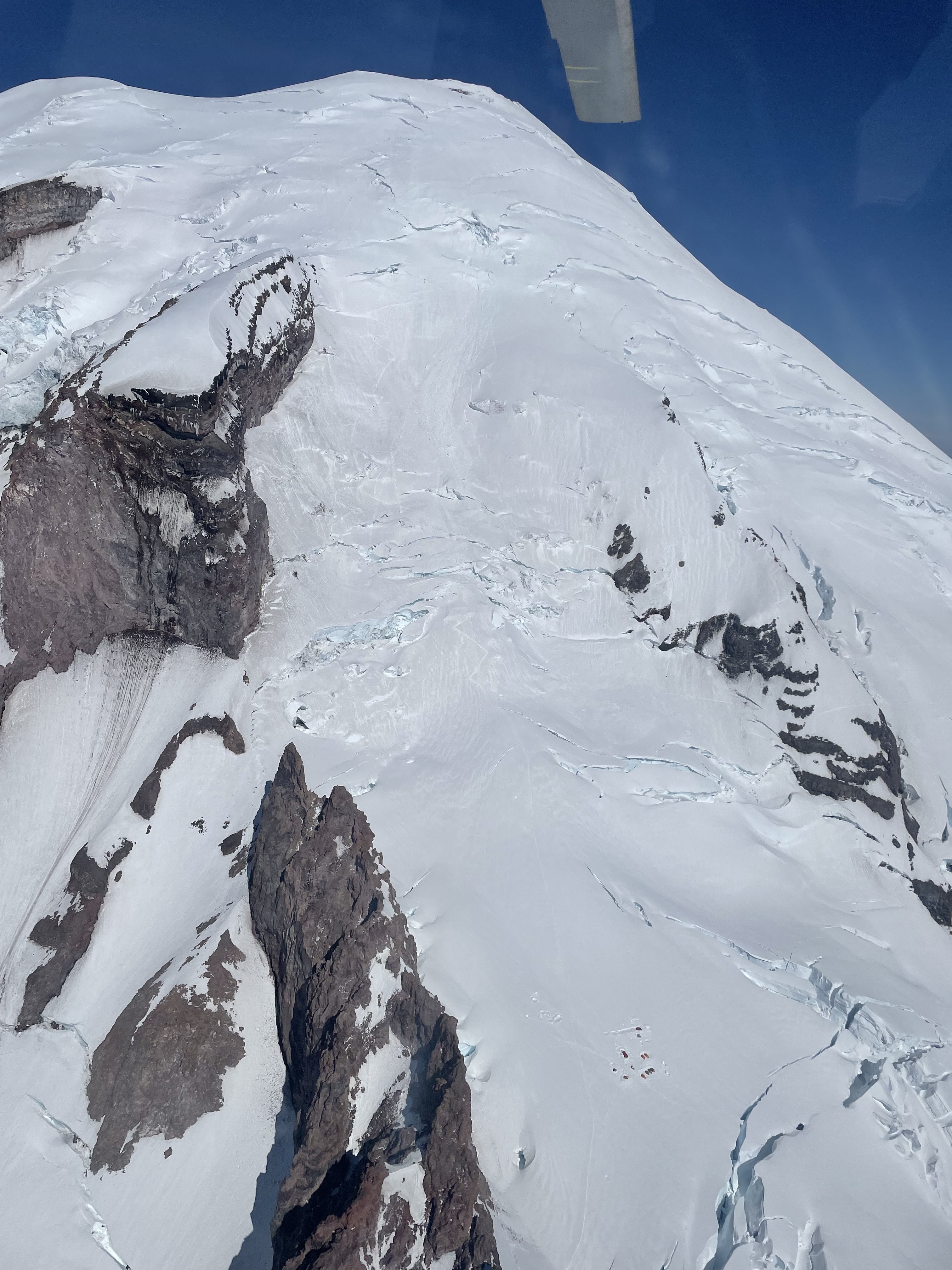
Emmons-Winthrop climbing route from Camp Schurman

Independent parties and guide services are successfully summiting via the Emmons-Winthrop route this week despite the heat advisory. The heat is making travel conditions challenging and have resulted in a longer and more demanding route.

Tracklog of Emmons-Winthrop descent from 07/23/2022

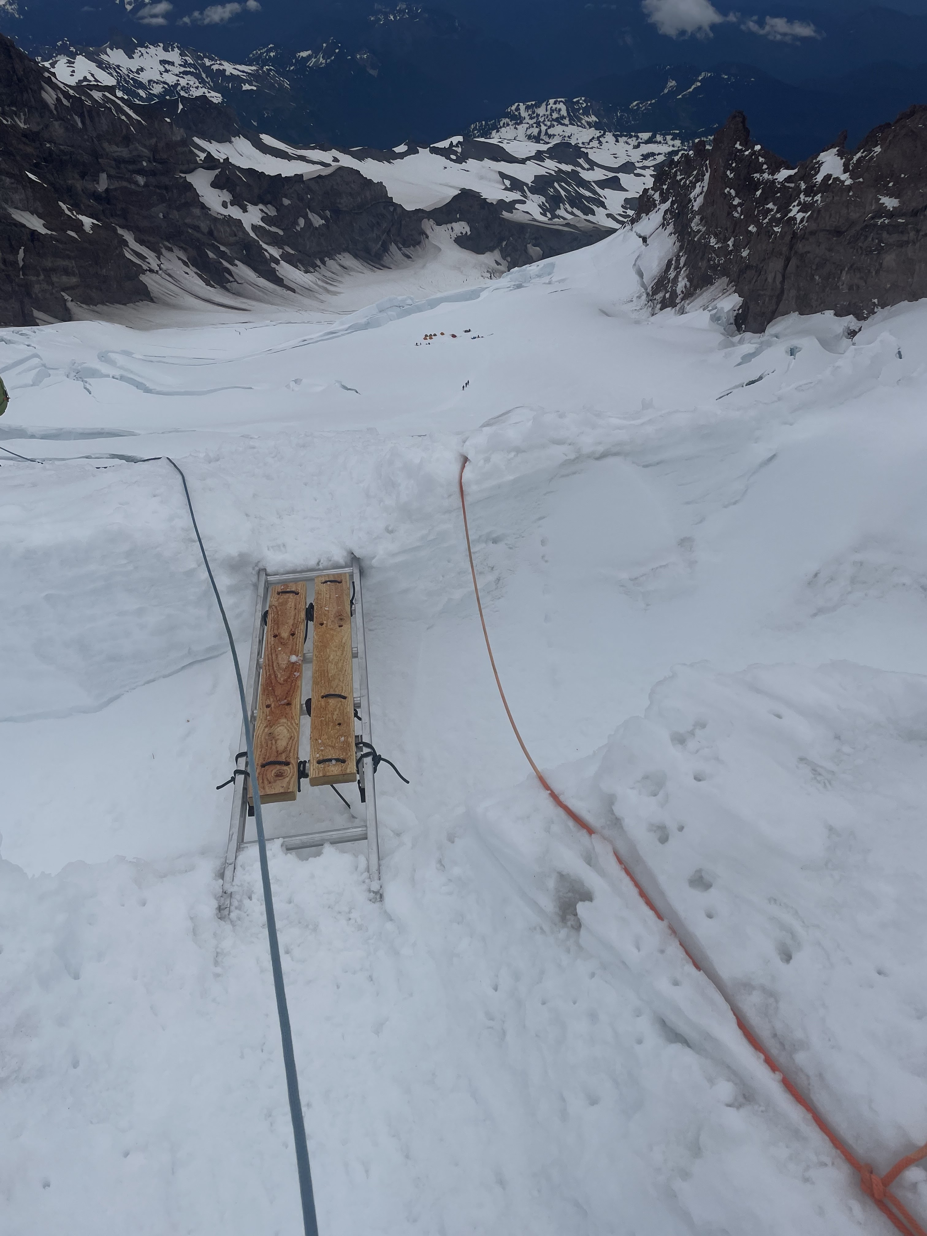
With the current heat advisory, Mount Rainier saw 17,000 foot freezing levels today.  The high freezing level and relatively calm winds are adding up to poor overnight snow-surface condition recoveries.  While the snow surface may be frozen during early morning hours, conditions deteriorate rapidly, and travel has been challenging on the Inter Glacier and the Corridor in the afternoon sun. Snow bridges are softening and crevasses crossings are becoming more interesting. Icefall and rockfall have been calving off Russell Cliff and the Womb all night, reminding climbers of the melting occurring above them.

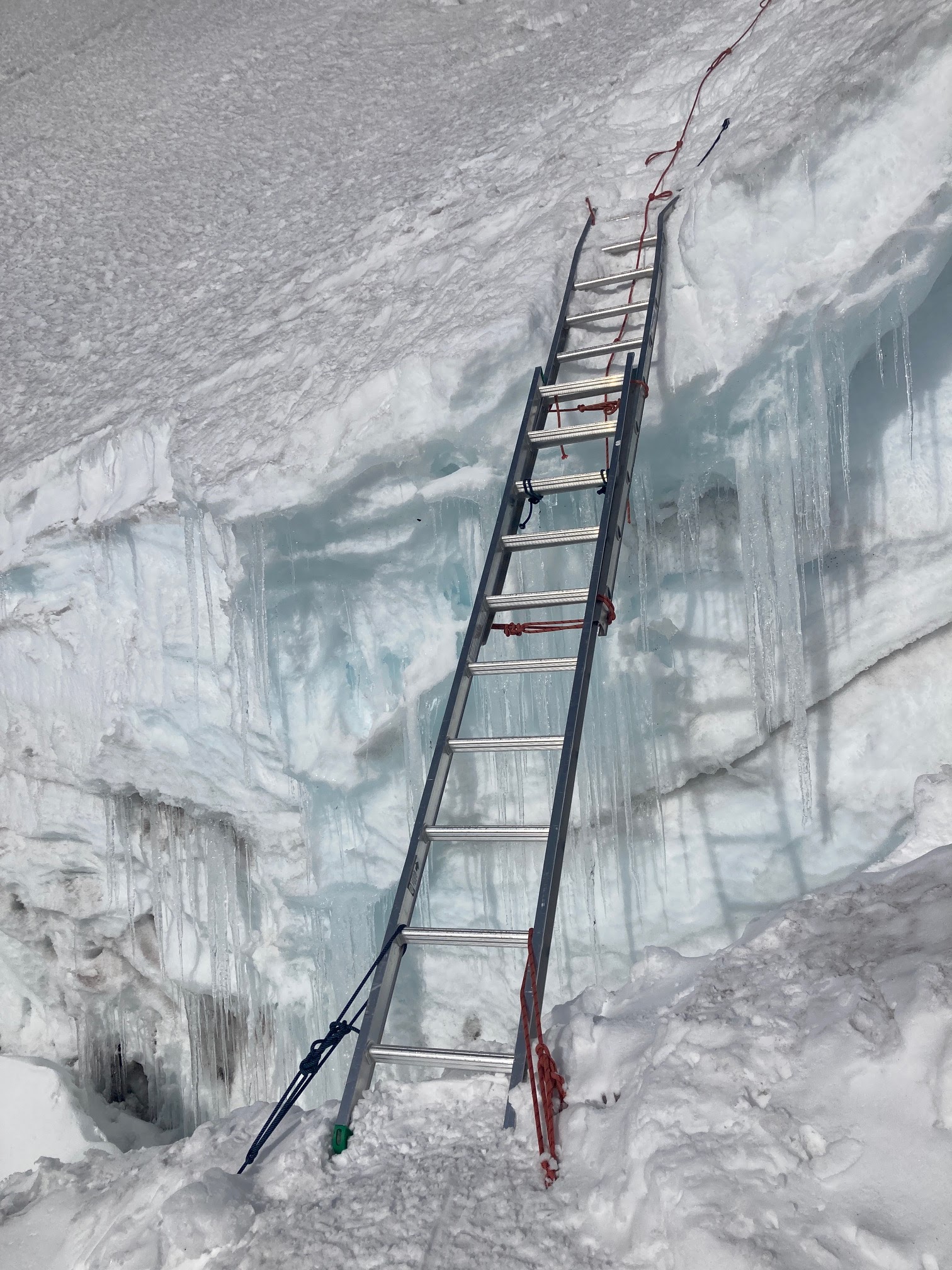
There are two crevasse crossings between the corridor and the alpine meadows that are giving climbers some difficulty. The first crevasse is wide with a soft snow bridge spanning it. Independent climbing parties reported a body sized hole in this snow bridge and a subsequent self-rescue. 

The second crevasse above the corridor was reported to have a fallen bridge. Independent parties were following the boot pack and jumping across this crevasse on their descent. It is difficult to judge the distance with tired eyes and difficult to execute a jump with tired legs. Jumping across crevasses is not a good idea, especially with crampons on. A caught crampon combined with the forward velocity of a jump can easily break a leg. If unable to step across a crevasse, it may be time to utilize your contingency plan. Guide services reported chopping a step in this crevasse to more easily step across it.  Consider placing running protection above crevasse crossings to help prevent pulling the entire team into the crevasse.

At 13,000 feet, there is no snow bridge allowing a direct crossing over the bergschrund. The route traverses hard climber's right to the Liberty Saddle to end run it.

Rangers crossing a poorly-bridged crevasse using running protection to manage fall risk in consequential terrain

Snow bridges that were crossable during the ascent may no longer be supportable or present on the descent. Think about contingency plans on the climb up. What will your party do if a bridge is gone on your way down? Have you already examined the crevasse from camp the afternoon before? Can you end run it? Can you find an alternate descent? Can you use other skills to get across? The safest contingency plan may be to climb back up to the summit and descend the Disappointment Cleaver route. Leave enough gas in the tank to do so. Bonus vertical is not fun, but neither is a shiver-bivy.

Climb at night, plan for a longer route, make conservative decisions, develop contingency plans early, and have a great climb.

Disappointment Cleaver Conditions 7/23/22

Camp Muir Viewed from above

Route conditions on the Cleaver remain quite good. The route itself is virtually identical to this route track from 7/19. The section from Ingraham flats to the transition onto the Cleaver is relatively simple, but this is an area with a lot of overhead hazard from ice and rock fall, and we recommend moving quickly through this point, and avoiding stopping while in areas of higher risk. 

Handlines coming on to the Cleaver

As you move onto the Cleaver itself there are a series of handlines on the route, if you choose not to use them just be aware that they'll be underfoot, and avoid getting your feet tangled in them. The Cleaver is still almost entirely snow covered with the exception of a few short sections of exposed rocks, and the route above the Cleaver is a straightforward series of switchbacks leading to the summit, with a number of crevasse crossings along the way. There are currently two ladders on the route, placed by the guide services to facilitate crossing crevasses that have fallen out.


Warming Temps and Changing Crossings

We are moving into a week of warmer temps, and as things warm up the condition of crossings on the route is going to keep on changing as things melt. Pickets are in place near many of the crevasse crossings for use as protection or for setting up belays, but it's always good to examine the state of any placement before you rely on it. We were asked the other day whether anyone went out each day to check the state of each crossing or adjunct in place, but the adjuncts on the route are placed and maintained by the guide services, and may not even be checked on a given day at all, while conditions can change massively throughout a single day. It's your responsibility to make decisions about the safety of any crossing, place protection as needed for your team, and investigate alternate routes if needed.

 Bottlenecking 

Warm temps and nice weather have brought more climbers to the mountain, especially on the weekends. Areas like the steeper switchbacks above the Cleaver, and some of the more complicated crevasse crossings can be prone to creating bottlenecks as climbers move through them. With more consolidated snow, just remember that you can move out of the boot pack to politely work past slower teams in areas where the terrain allows, and if you find yourself waiting to cross a point as other groups pass through, remember to stay patient and cheerful, this can even be a great chance to move off to the side and take a quick snack break with your team.

Thursday, July 21, 2022

Please Rope Up

Recently there's been an increase in the number of climbers travelling un-roped.  This includes climbers ascending the Emmons glacier to Camp Schurman, coming off rope as they descend the corridor, and even travelling off rope for their entire ascent of the upper mountain. This is extremely ill-advised! Significant hazards are always present in these areas.  With warmer temperatures, the odds of punching through into an unseen crevasse are even higher.

Crevasse falls are surprisingly more common than you would think.  Some parties experience a crevasse fall and a party member gets injured, but they are able to self-rescue back to the surface.  This type of scenario will still trigger a rescue because the patient can no longer walk out. More often, the party does not have the skills (or enough people) to effectively get the party member out of the crevasse.  Many parties think they have trained, but find once the crevasse fall happens in real life, they don't have the equipment or skill or the number of people they need to get their party member out.  Also, imagine when you’re tired, sleep deprived, have cold fingers, and the wind ripping around you AND THEN having to deal with a partner in a crevasse.  On your ascent, you should always keep the crevasse fall potential in mind and have enough of a energy and safety margin to deal with it.  

Climbing rangers wish that they could pass the tragic lessons on to you that many other parties have learned over the years.  One of our ranger’s first body recovery due to a crevasse fall was in 1992 (that’s 30 years ago!) on the Emmons Glacier.  The surviving member of the party wrote a book about his experienced title The Ledge.  And this party was roped up!  During the subsequent three decades there’s been scores of other tragedies and near misses due to climber’s not being prepared to deal with a crevasse fall.  Please take this hazard seriously!  

Climbers next to the crevasses right below Camp Schurman on the Emmons - roping up is advised here.

Ski mountaineers have also been seen travelling un-roped.  When done well by experienced and well-thought-out mountaineers, skiing can mitigate crevasse falls and be a fun, faster, and less exhausting way to get up and down.  However, when it's not done well, it is turning out to ADD risk to many unknowing climber's trips.  The rationale for ski mountaineering in its most simple application is sound.  Having skis on as you cross the glacier distributes your weight over a larger area and this minimizes the potential for falling through an unseen snow bridge.  But, there’s common pitfalls that many skiers don’t anticipate..

Skiers need to have partners and we recommend carrying ropes, too.  To avoid accidents, skiers also should know when to take the skis off and put a rope back on while they ascend or descend!  Ski mountaineers who chose to descend un-roped should carry two separate ropes in their party in order to effectively rescue a partner who has taken a crevasse fall. A ski mountaineer carrying their skis on descent has no flotation advantage from their skis and should act and protect their climb just like any mountaineer.  Skiing down a steep glacier roped-up is not a good idea, nor fun.  So skiers generally un-rope as they ski down. This would not be a big risk if it weren't for two factors: 1) the slope angle, and the 2) surface conditions.  

From 13,500 to 11,000 feet, Mount Rainier is steep, often greater than 35 degrees.  It isn't groomed, of course, and surface conditions are often either rough, broken, or icy.  Because taking skis off is inconvenient, skiers will often attempt to ski through areas of great exposure like a steep corner around a serac with a crevasse below it.  If you haven’t climbed the route you’re about to ski, use extreme caution.  Also, please realize that skiers do fall and every skier has taken a fall, and many times it’s not predictable.  It’s why bindings are manufactured to release.  Simple tumbles, especially in unknown terrain can often be deadly on Mount Rainier.  Skiing off the mountain at these high altitudes isn’t great skiing most days (think survival ski turns) and tumbles often result in uncontrollable falls. Very skilled skiers have been seriously hurt and killed on Mount Rainier.  Don’t plan on your skiing ability to prevent a serious injury or death.  Climbing your ski route, waiting for fortunate conditions, down climbing icy sections, and always having the appropriate rescue equipment is essential.  Skiing is rarely good above 11,500'.  Our best advice is to plan on using normal climbing techniques for ascending AND DESCENDING from and back to this altitude in the summer.

What we've seen lately is befuddling!  Skiers have been walking down un-roped on lower sections of the glacier where it is warm and late in the day.  In the specific places we've seen this happening, it was the worst of all worlds.  No rope, no skis, warm afternoon conditions, and crossing crevasses.

The climbing rangers have had a serious rescues off the upper mountain almost every week.  Crevasse falls are a major cause of these rescues.  Please think about removing these commons errors from your scenario that will keep you from falling in in the first place.

Please rope up while on glaciers!  It is always the crevasse that you’re not planning on falling into that causes the most problems.

Wednesday, July 20, 2022

Disappointment Cleaver 7/19/22

Overall the Disappointment Cleaver route is in good condition. High freezing levels will continue to cause frequent route adjustments such as widening cracks and less supportive bridges.

A route tack recorded on 7/19/22.


With warmer temperatures we witnessed increased rock and icefall. The cleaver is still fairly snow covered. However, as the snow continues to melt be aware of parties below you as you walk on exposed rock. Consider pausing until there are no parties below you and be aware of parties climbing above. 

As conditions soften, pickets may begin to melt out with the warm temperatures. we recommend inspecting the integrity of the placement before trusting any route adjunct - this goes for fixed lines, fixed pickets, ladders, and planks.


Handline on the Cleaver. 

If you find yourself considering jumping across a crack, consider looking for another way to cross. While jumping across a crack may work, it is also an easy way to catch a crampon. Many people are injured attempting to leap across cracks.

Both photos above: Crevasse at 12,800'.

As the weather warms, ladders placed over crevasses may begin to melt out, test the stability of the board before committing to crossing over. As a testament to the rapid pace of change on the upper mountain, this board, pictured below needed to be moved repeatedly on 7/20 

Crevasse crossing at 13,200'. 

Please double check your campsites, the public shelter and break points along your route for trash you or others have left behind and leave the area better than you found it, thanks for your help in keeping Mount Rainier clean. 

Saturday, July 16, 2022

Emmons-Winthrop Update


For this point in July, the Emmons is holding up quite well. Mount Rainier has experienced consistently high freezing levels in the past week (~14,500ft) and the extended forecast is predicting this trend to continue into next week. With this warming, expect to encounter suspect snow bridges, widening cracks, and a continually changing route.

View of the Emmons-Winthrop

Even though there may be a well worn boot-pack in spots, this route may have been established when bridges were more supportive and conditions were different.

Snow Bridge at 11,400


Snow Bridge at 12,800 

Climbers are encouraged to analyze their decisions when picking the best route, don’t blindly follow the path most traveled. Consider options to end-run hollow bridges, take a different path, or if it’s not feeling right head back to camp!

Friday, July 15, 2022

South Side Aerial Photos. It's looking good!

Coverage is looking good on the Mount Rainier. Climbing routes and some ski descents seem to still be in great shape! 


The Kautz glacier, the Turtle, the Wilson glacier/Furher Finger, and the Nisqually.


The Kautz glacier, the Turtle, the Wilson glacier/Furher Finger, and the Nisqually.


A view of the upper and lower Kautz glacier and the Van Trump zone.

Thursday, July 14, 2022

Route Switch! Ingraham Direct to Disappointment Cleaver

As of 7/13, the guide services have switched their standard route from the Ingraham Direct (ID) to the Disappointment Cleaver (DC). Markings such as wands and ladders have been removed from the ID; handlines are available on parts of the DC route, but should not be clipped into, just used as a hand hold.  As always, use your own judgement as to where and how to climb.. and if you’re unsure - take the time to focus on training instead of the summit and as always, consider going with one of the amazing guides who operate on the mountain!

Emmons-Winthrop Update

The most trodden Emmons-Winthrop route remains generally similar to what it was a week ago, but with much warmer temps, crevasse crossings have begun to melt out, and the route has switched to go over alternate crossings in some areas. While the clearest boot pack may still clearly lead to older crossings, it’s a good idea to evaluate each one, as changing conditions may have negated their stability. Always remember that the boot pack here is simply where people have walked before, and that it doesn’t necessarily mean that the route it takes is the safest or most advisable. This route is constantly changing, especially with warmer temps.

Crevasses above the corridor
The route at glacier basin still crosses over white river via snow, but this crossing is moving higher as the snow melts. Caution is advised when choosing a route in this area.

Glacier Basin

Recently there's also been an uptick in the number of climbers travelling un-roped, including climbers ascending the Emmons glacier to Camp Schurman, coming off rope as they descend the corridor, and even travelling off rope for their entire ascent of the upper mountain. This is extremely ill-advised. Significant hazards are always present in these areas, and with warmer temperatures the odds of punching through into an unseen crevasse are even higher. 

The mountain viewed from Camp Schurman

Crevasses are present in the lower Emmons, between Camp Schurman and the Emmons Flats, and throughout the upper mountain. Climbers who feel they are in an area where the risk of an un-arrestable fall is higher than that of taking a crevasse fall should consider other measures, such as placing running protection, and adjusting rope spacing.


Sunday, July 10, 2022

Ingraham Direct Route Update 07/09/2022

Sunset over Mount Adams from Camp Muir

Guide services are still utilizing the Ingraham Direct route at this time. The route is still in good condition and is expected to be in use for the next week or so. The Ingraham Direct route has migrated climber’s left towards Gibraltar Rock from a couple weeks ago. It is no longer switch-backing over to the top of the Disappointment Cleaver. This route variation avoids the large serac hazard that was present on the previous route variation.

Ingraham Direct Route from Ingraham Flats

Overview of the current Ingraham Direct route from 07/09/2022

Icefall and rockfall coming off Gibraltar Rock

Serac hazard is minimized with this route change, but rockfall and icefall hazard from Gibraltar Rock are of concern. The mountain is seeing increasing freezing levels over the course of the weekend, reaching 15,000 feet levels by Monday. These are the highest freezing levels the mountain has seen this year and only the second significant warming event. Intermittent clouds will be shrouding the mountain all weekend and may prevent substantial overnight recovery. Don't be surprised by soft climbing conditions, softening snow-bridges and more climbers on the mountain. Mitigate hazards by climbing early, taking breaks in strategic locations, and getting back to camp early.

Ladder spanning crevasse on Ingraham Direct

Second ladder crossing on Ingraham Direct
 
There are currently two ladders on the route starting at roughly 11,600' adjacent to Gibraltar Rock. The first ladder is horizontal, spanning a relatively narrow crack, and has planks covering the rungs allowing for a fairly simple crossing. The second ladder crossing is made up of two ladders lashed together spanning a wider crack and at an upwards 45 degree angle. There is a handline secured with pickets above this ladder. This ladder crossing is more complex and parties may be struggling or moving slowly here. Expect bottleneck at ladder crossings, be patient, be courteous, stick together, and keep a head’s up for rockfall and icefall coming off of rocks.

Looking down on Camp Comfort from 13,500 feet

Wednesday, July 06, 2022

7/6 South Side Aerial Photos

Below are aerial photos from the south side of Mt. Rainier over the weekend.  These may be helpful for broad trip and route planning purposes.

Looking up the broad and well defined ridge of Success Cleaver


Kautz Glacier

Fuhrer Finger (the couloir with ski tracks) & Fuhrer Thumb 

Ingraham Direct. Photo taken above Cathedral Rocks. 
Note Ingraham Flats tents for reference

Tuesday, July 05, 2022

Ingraham Direct 7/5/22

Guided and independent parties are still climbing the Ingraham Direct which is unusual for this point in July. One ladder is in place (see photos) as well as a small plank crossing. More ladders may to go up in the coming days. The route is still in decent condition, though there are many thin snow bridges from 11,000 feet to 13,000. The risk of falling or punching through into a crevasse is greater than normal for this time of year on the 'standard route' out of Camp Muir. When crossing crevasses, remember large steps are OK, but jumping over them is often how people get hurt or fall. If you find yourself with the urge to jump over a crevasse, consider walking to one end or the other to find a reasonable place to cross.  Remember to keep your teammates tight on the rope as they are crossing to reduce the amount of slack in the rope. Parties ascending on skis should know that the surface conditions and the open crevasses are not ideal for skiing down the Ingraham Direct.  Multiple skiers have hiked up their skis and then walked them back down due to "survival" ski conditions.

The freezing levels are remaining low around 9,000 to 10,000 feet for the upcoming days.  but variable weather has been turning some parties around. Expect more challenging weather conditions in the near future - the forecast looks a bit mixed this upcoming week. Parties hoping to summit should be prepared for whiteout navigation, variable weather, and high winds. Recording a track on a GPS device can help with navigation on the way down - and can sometimes be the only way to navigate back down the mountain.


Ladder around 11,700' on the Ingraham Glacier

Looking uphill from Ingraham Flats


Looking towards Gibraltar Rock, climbers approaching the ladder

Looking down the Ingraham Direct

Muir to/from Paradise

If you are traveling to Camp Muir and plan to glissade down use caution. On your ascent, scope out paths without rocks, holes and other hazards.  Also, be sure to check out this navigation sheet to help travel up and down in a whiteout.  Every year parties get lost on the Muir Snowfield in a storm -- don't let this happen to you!  Set a GPS track, have a map downloaded onto your phone ahead of time (there's limited cell service inside the park), and have a plan with your partners if you get separated.  

Two glissade chutes with deep holes at the base; Panorama Point

Sunday, July 03, 2022

Emmons/Winthrop 7/2


Many parties had successful summits in July; reporting mostly good cramponing conditions and an established bootpack to help navigate around crevasses. 

Snowbridges that the main bootpack crossed were starting to weaken with the heat over the weekend and new areas to cross may need to be found. In the alpine meadow zone (around 12,000 to 13,400 feet) very firm cramponing and slick surfaces exist. Many independent parties were looking to ski from the summit. Many did not due to firm, icy, and variable snow conditions near the summit. There are also several large crevasses to avoid.  

Glacier Basin trail to Camp Schurman is losing snow quickly. Patchy snow exists starting at around 5500 feet. Consistent snow starts at Glacier Basin. Some small crevasses are starting to open up on the lower Inter Glacier. Staying roped up isn't the worst idea on the Inter Glacier - crevasse falls are possible!  

It's definitely prime time for climbing the Emmons/Winthrop Glacier route.  As the weather patterns stabilize and the glacier starts to break apart more, this route historically goes "out for the season" sometime in the beginning of August.  Hope to see you up on the eastside soon! 

The route on the Emmons/Winthrop to the summit

Looking up the Inter Glacier from Glacier Basin

Looking down valley from Glacier Basin