Saturday, September 26, 2020

Storming into "Winter Season" on Mount Rainier

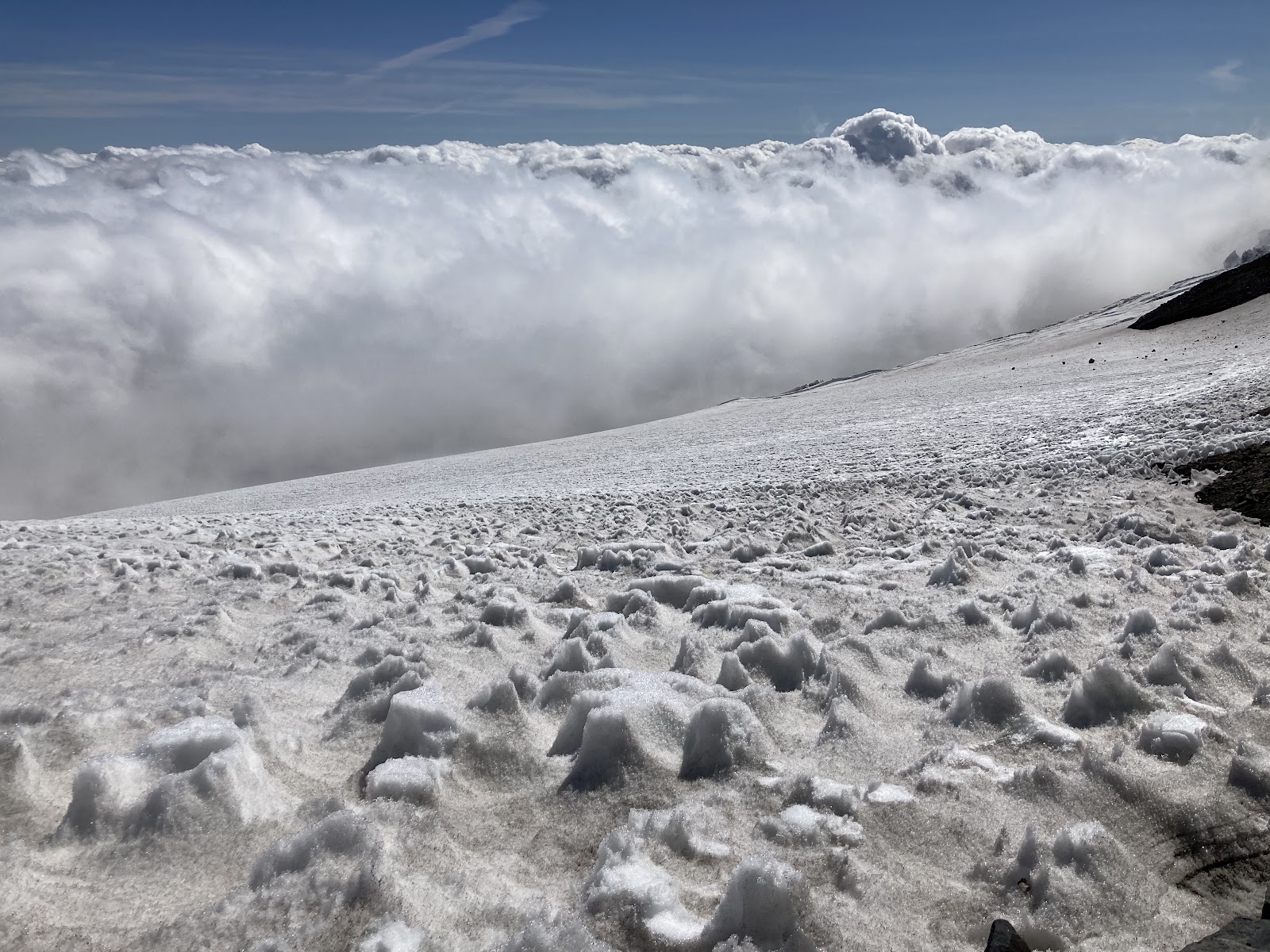
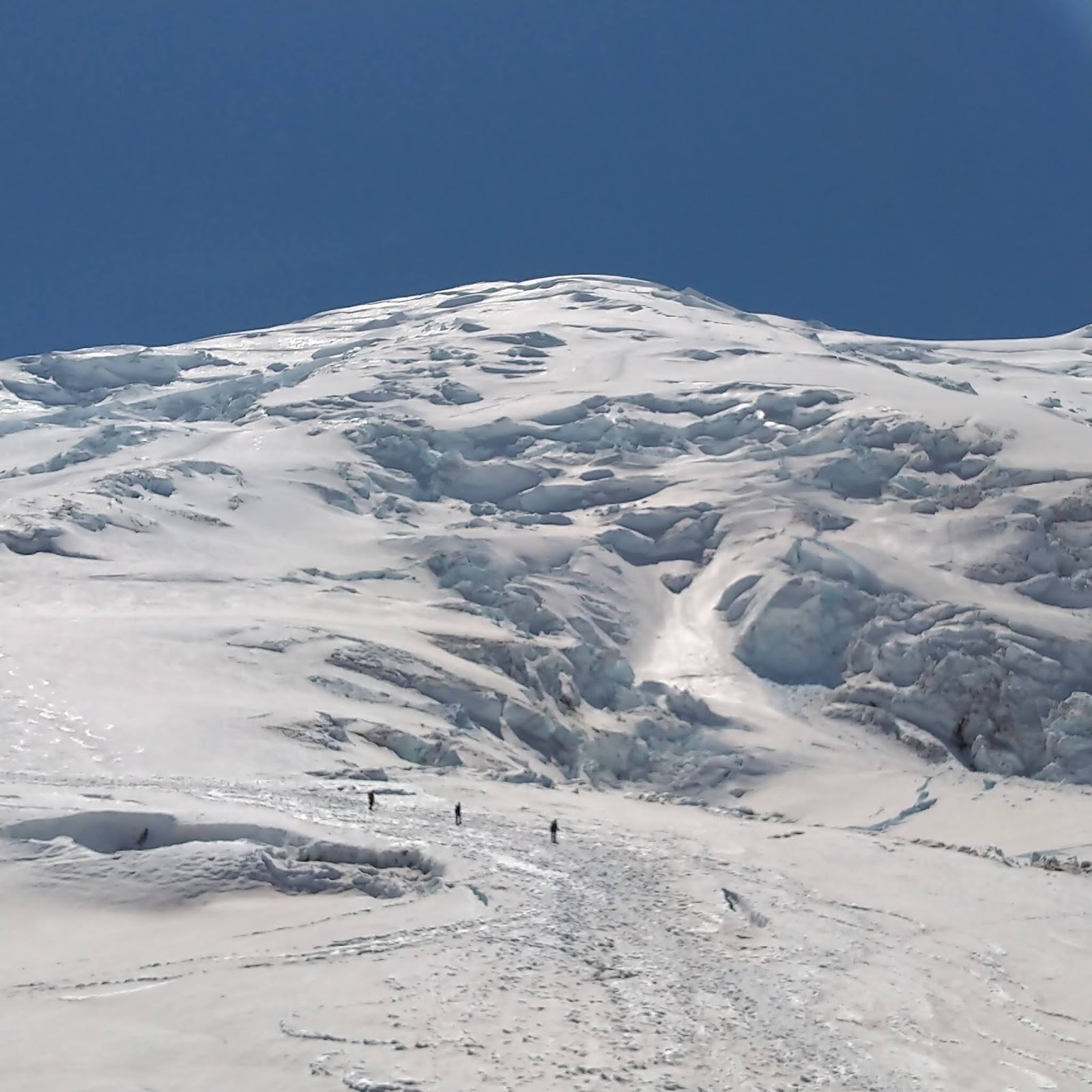
Cancelled climbs and cold weather closed out the regular climbing season on Mount Rainier.  Guide services are finishing their trips for the year and all of the route adjuncts (handlines, planks, ladders, etc.) are being taken off the mountain.  Dangerous conditions currently exist on the mountain with crevasses on the lower slopes being just barely covered with this new blanket of snow.  Be prepared to rope-up: have helmets, harnesses, ice axes, crampons, pickets and other glacier travel equipment with you - just to travel to Camp Muir!  In the regular season, a trip to Camp Muir can be done without that extra equipment, but this year's late-season conditions are extreme and especially dangerous in this transition time with icy crevassed surface conditions being hidden by fresh snow.  

Rain, then snow fell on the mountain last week.  Drifts up to three feet deep!

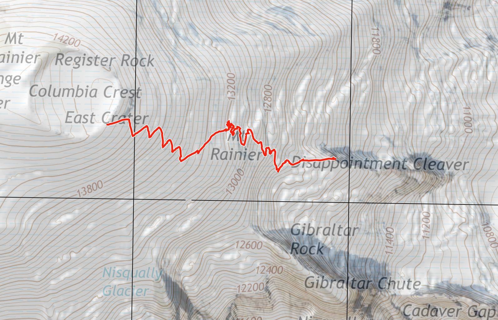
No climbers have been on the Emmons-Winthrop or the Kautz Glacier Route in the last couple of weeks.  Both can be considered "out" for the year.  With the guides removing the adjuncts and fresh snow, the Disappointment Cleaver Route can also be considered "out" for the year.  Any climber attempting the summit this time of year should consider it an off-season climb and be very experienced, totally self-sufficient and realize that any emergency help could be not just hours, but days away.  

Late season storms on the mountain can roll in with little warning and can be much more vigorous and longer lasting than summer squalls.  Please check the weather forecast before starting your trip - click on the Weather Resources tab above for some starting places - and because forecasts can be wrong, prepare for the unexpected!  This last week we had winds reaching Category 2 Hurricane speeds at Camp Muir which sits well below the actual summit.  Stretches of beautiful summer-like weather can also be possible, and late-season visits do offer more solitude than the more popular times, but please be cautious this time of year.

All climbers still have to pay the annual climbing fee (which can be done online ahead of time) and obtain a climbing permit (which has switched to self-registration for the winter season and can be done in-person at the trailhead).  Enjoy the change of the season!

Monday, August 31, 2020

General "Late-Season" Route Update - August 31st

It's already the LAST day in August!  Where did the summer go?  There's already a hint of autumn in the air and it felt like the first of many winter storms just passed through last night.  The next week's forecast looks to be unseasonably hot - freezing levels jumping from 10,500 feet back to 16,500 feet - but, as September rolls around please come prepared for both the summer heat and the inevitable start to stormier winter weather.  

Late-season conditions: broken glaciers, rocky peaks, and lingering clouds.
As we move into the late-season here on the mountain, registration changes will occur; check the park's permit website for the latest, but here's the gist: 

Effective Tuesday 9/8/20 for the remainder of September 2020, climbers can self-register on WEEKDAYS (M, Tu, W, Th) outside the Paradise, Longmire, or White River WICs. Climbers who wish to climb on WEEKENDS (F, Sa, Su), including single-push climbers, must submit a reservation application at least 2 DAYS prior to their trip start date and receive their permit via email. ALL climbers must still pay the annual climbing fee. All climbing permits after Sunday 9/27/20 will be by self-registration.

Here's a run down of the common routes being climbed right now:

DC - In general the Disappointment Cleaver Route has continued to be well-maintained with the hard work all the guide services have been putting in.  The route has been climbed by both guided and independent parties in the last couple days and the route remains in the same general location as the track log posted in the August 6th update.  Be cautious both on the ascent to Camp Muir and in the camp itself with crevasses starting to open.  There's some large cracks in camp and on the snowfield that are easy to avoid, but could cause serious injuries if one were to fall in them.  

E/W - This route has been much less popular in the last two weeks with many parties turning around due to the circuitous nature of the route and the high consequence crevasse crossings melting out.  An experienced team made it to the summit last week, but this route should be considered "out of season" as a standard route.  

Kautz - Not many parties have climbed this route in the last couple weeks, but the most recent blog post from August 21st is still accurate.  The ice pitches will continue to grow in length and the crevasses above the Wapowety Cleaver will continue to become more complicated to cross.  The approach up the Comet Falls Trail to this route is the preferred method - crossing over the lower Nisqually Glacier has become very difficult.  

See you in September!

Friday, August 21, 2020

Kautz Glacier Route 2020 Update


The Kautz glacier route is in good climbing condition. The approach for the climbing route can be started from two different locations. The the most common approach starts from Paradise and crosses the Nisqually and Wilson glaciers. The alternate approach starts downhill from paradise at the Comet Falls trailhead. The Comet Falls approach is longer with more elevating gain starting at an elevation of 3,700'. Comet falls is the preferred late season approach with its well developed trail and ample water access that is snow free up to 7,600'. Trail runners instead of clunky mountain boots for this section of the approach can be a bonus if you don't mind carrying them later once you switch out footwear.

Climber on the approach trail with Comet Falls in the background.


The snowfield starting at 7,600 to the castle at 9,300' is covered with large sun-cups. These "cups" will continue to be more pronounced as the summer wears on. Be prepared for slower travel up these slopes with lots of mini zigzags to navigate the terrain. Regardless of what time of day you hit the snow-line you should plan on using your climbing boots. The slopes become steep enough that you will need to kick-in steps. If it is late in the day and the snow is beginning to firm up then crampons will be necessary also. 

View of upper Van Trump with the Castle visible along the right hand skyline. 

The Castle has many good bivy options and running water sources. This is a reasonable location to start an upper mountain climb from, but realized that it is still 2,000' below Camp Hazard. The Turtle snowfield located between the Castle and Camp Hazard is sun-cupped with mostly firm snow and glacier ice. Having an ice tool in-hand along this section could come in useful. Camp Hazard at 11,300 has many good bivy locations as well, but water is scarce this time of year and you may have to spend some time searching. 
Sunrise on the Turtle snowfield with sun-cups visible along the snow

The fixed rappel lines leaving the Wapowety cleaver at 11,300' are in reasonable condition. Using the fixed ropes, climbing teams should be able to either rappel or down-climb off the cleaver onto the transition slopes that lead out to the Kautz glacier. Please remember that fixed soft goods are always subject to damage and should be assessed for safety before using. 

View from the rock step and transition slopes at 11,300' 

The transition slops leading out to the glacier are comprised of rock scree and ice. The glacier that extends above these transition slopes holds a large active ice fall that can catch you off guard and send you running. Many parties manage this section by not roping up until they are clear of this deposition zone. Once you reach the main climbing slopes of the Kautz glacier you will find the first 200' of the route to be low angle ice. This lower ice section can be climbed using various techniques with a minimum number of ice screws. The transition zone between the lower and upper ice pitches is firm snow and is walkable. 

Climber approaching the upper ice pitches on the Kautz glacier


The main ice climbing headwall is 300' tall and can be climbed easily in two pitches with a 60m rope. Simul-climbing would be a good option for skilled parties that want to move quickly through this section. The climbing at it's steepest point is approximately 50 degrees. Six to eight ice screws with draws would be a reasonable number of pieces of protection for this section of ice climbing.  The ice slopes hold shade for most of the morning hours, but there is running water along these icy slopes so keep an eye out for opportunities as you climb. The ice climbing tops out at 12,000' with a view of Point Success and the upper Wapowety cleaver. 

Climber topping out on the ice climbing pitches.


Glacier travel across the upper Kautz alpine bowl to the upper Wapowety is covered with numerous crevasses. Many of the cracks leading out above the ice climbing are small enough to step across without much end running. As you approach the scree slopes of the Wapowety the crevasses get larger and end running will be necessary. Climbers can expect to encounter moats along the rock slopes of the Wapowety where the cleaver meets the glacier.  

Climber crossing a snow bridge over the bergschrund near the crater rim.

From the top of the Wapowety at 13,000' you can see the crater rim on a clear day. Crossing the upper slopes of the Nisqually teams will encounter more crevasses, trail breaking through knee high penitentes,  and a large bergschrund near the top. The schrund can be end run in either direction. This route is a true mountain experience and should not be missed. Have fun, be safe, climb smart!


Thursday, August 20, 2020

DC Conditions Update 8/20/2020

 The DC route is due for a change and the guides are busy working on a re-route.

The current track has held up well, but the recent spell of warm weather has caused many of the crevasses to open significantly and for the Ingraham/Cleaver transition (the Bowling Alley) to become more difficult.

Looking at the Bowling Alley from the Ingraham Glacier, ~11,400'
 
Getting off the glacier and onto the rock requires some scrambling in loose blocks with overhead hazard. Move through this area as quickly and safely as possible and don't let your rope get caught up in the rocks.

We expect a transition to the classic late-season line from the top of the cleaver out to the Emmons Shoulder but the guides may find a more direct option. Either way, expect them to keep the route established but be aware of dynamic events such as snow bridge collapses and ice fall that may necessitate your own route finding.

Several parties climbed into clouds on the upper mountain in the last week so we'd also like you to please keep in mind that navigating through a heavily crevassed, high elevation glacier in a white-out is a risky endeavor at best.

Climb safe!

Emmons Winthrop & The Inter Glacier Approach - August 17th

Both the Inter Glacier and the Emmons are becoming harder to navigate as we move into late August.  The Inter Glacier approach has a fair amount of ablated ice exposed and warrants the use of crampons, ice-axe, climbing helmets, ropes and crevasse rescue equipment.  Due to late season conditions, be anticipating a more complex ascent to Steamboat Prow or Camp Curtis.

The Emmons route generally follows the route described in the previous post, with the addition of more thinly bridged crevasse crossings & plugs.  Be cautious while maneuvering these features and be anticipating the need for implementing belays to cross them.

The climbing route up the Emmons has been more involved as we transition into late season.  With this being said, anticipate your climb taking longer than it typically would early season.  This coupled with the elevated freezing levels, leaves the possibility for climbing parties in a position to find themselves on the upper mountain late in the afternoon in rapidly warming snow conditions and decompensating snow bridges.  Try to employ the use of a strict turn around, and do your best to stick to your itinerary.

Climb safe!


Looking down onto the Inter Glacier from Ruth Ridge


Looking at the Emmons-Winthrop from the top of Steamboat Prow


The view of crossing from the Corridor to the Alpine Meadows


Crossing from the Upper Alpine Meadows to Liberty Saddle


Looking from Liberty Saddle down towards
the Emmons and the Alpine Meadows

Thursday, August 13, 2020

Emmons/Winthrop Update - 8/12/2020

The Emmons/Winthrop route is largely unchanged from the last post from August 4th.  There have been many successful summits on the route in the past week.  However, climbers were reporting thinning bridges.  The large plug in between the Corridor and the Alpine Meadow is surely getting spicier (that is, more unstable) so be sure to assess what you are stepping on as you move up the route.  As always, an old boot pack DOES NOT guarantee you are on the safest line up the glacier.  Stay engaged on the way up, as well as the way down, as glaciers are always changing.  

The number of climbers is decreasing as we move through August, making for a quiet route and camp.  At Camp Schurman,  crevasses are invading the usual tent sites on the Winthrop.  Make sure to assess your camp carefully and probe for crevasses.  There is running water on the glacier surface above the helipad on most afternoons right now.  And near constant rockfall off of Curtis Ridge makes for great alpine entertainment.  Come up and enjoy the last remaining days of summer on the mountain.  It's a lovely time to be in the Park. 


Thursday, August 06, 2020

Disappointment Cleaver Update 8/6/2020

Crevasses starting to open and show historic snow layers.

The Disappointment Cleaver route is now in "normal" August conditions. That means there are many large crevasses that must be end-run and significant rockfall hazard. This is nothing out of the ordinary for a DC climb at this time of year however.

From Camp Muir the route ascends into Cathedral Gap with just a few crevasses to mind. Rockfall potential does increase as the route nears the snow/rock transition, so we do not recommend parties stop when under the cliffs of Cathedral Rocks - both on the Cowlitz AND Ingraham transitions.
Climber admiring the "Canine Tooth" serac, just above the Cleaver.

The ascent of Cathedral Gap is all rock so make sure to shorten the interval between climbers and pick the rope up out of the rocks. From the top of the Gap the route continues on rock for a few hundred meters and then transitions to the Ingraham Glacier and on into Ingraham Flats.

Above the Flats there is a single ladder installed at approximately 11,300’ (known as "high crack"). After crossing the ladder you’ll descend slightly before entering the Icebox and Bowling Alley area. Here there is significant overhead hazard and we recommend moving through this area as efficiently as possible.
Rope teams traversing out below the "Wisdom Tooth" right around 13,000'.

Once your team has completely left the snow it’s best to either quickly shorten the rope interval between climbers or move quickly to the crest of the ridge and reset the rope there. Either way your goal here is to ascend the lower third of the Cleaver without dislodging rocks on climbers below and staying on route.

The Cleaver is marked with wands and after navigating the labyrinth of the lower third the route regains the ridge crest and the climbing becomes more straightforward. The top of the Cleaver will be the last rocks you encounter before the Crater Rim.

From the top of the Cleaver to the summit the route end-runs several massive crevasses and even descends around them in a few places. The guides have placed fixed protection for running belays in several places so familiarize yourselves with using this technique before you encounter them on the route.  Tooth-like seracs are looming over the route in certain places - don't linger below these detached icy features!
Most recent track log of the DC Route.

Other than a few steep sections the climbing on this part of the route is quite pleasant and not too long, distance-wise, for August.
Always remember to leave early and keep plenty of gas in the tank for the descent. Descending on a warm summer day can be extremely hot and fatiguing and many climbers have mentioned that they wish they got an earlier start upon returning to Camp Muir.
Upper mountain photo taken from the top of the Cleaver.

Above all, be safe and have fun!

Emmons-Winthrop Route Update 8/4/2020


Camp Schurman has been busy. Warm temperatures and sunny skies have made for pleasant climbing conditions this week. As August begins, climbers are noting rapidly changing conditions on the route.

From Camp Schurman to the Emmons Flats: Open crevasses running in all directions are beginning to make travel more circuitous. At Emmons Flats there is still enough room on the glaicier to pitch your tent, but you'll be a stone's throw from open crevasses.

Emmons Flats to the Corridor: straightforward, with multiple options for gaining the Corridor.

The Corridor: open crevasses crisscross the corridor in many places. Climbers should evaluate the strength of crevasse bridges as they cross them; especially during the heat of the day. Overall, travel on the corridor is quite good for early August.

Looking into the depression at 11,500 ft.

The Corridor to Winthrop Shoulder: just beyond the Corridor at 11,500 feet lies an interesting feature. A huge depression has formed where the ice between two crevasses has sunken into the glacier. This feature, also known as a plug, is where climbers have been travelling to access the alpine meadow. The uphill portion of the plug is unsupported below and showing signs of instability evidenced by stress cracks cutting through it. Below is a photo of this feature from above; the route cuts right through the center of the cavity. 

The 11,500 ft depression from above. Note the detached upper edge of the snow bridge.

Rangers noted the cracks in the bridge had widened significantly in the few hours it took to climb to the summit and descend back across the feature. Consider using running belays or belaying party members across unstable features bridging crevasses. 

Around 11,800 feet, the old boot pack trends climber's left towards another crevasse with a small unstable bridge. Luckily, this can be avoided by travelling climber's right and slowly descending to a much better crossing at 11,700 feet. After crossing this crevasse, straightforward climbing leads up the Winthrop shoulder.

Winthrop Shoulder to Liberty Saddle: switchbacks meander up the shoulder until 13,000 feet. Here, the boot pack heads climber's right towards Liberty Saddle. The travel here is obvious and gradual.

The route towards Liberty Saddle from 13,400 ft.

Liberty Saddle to Summit: textured snow and penitentes guard the last 800 vertical feet to the crater rim. Some large crevasses near Liberty Saddle are easily crossed on large snow bridges.

The final pitch from Liberty Saddle to the Crater.

Inter Glacier Update: Snow has been melting fast from the Inter. Several crevasses have opened up as well. Crampons might be necessary in some places, and roping up may be a good idea too. Remember to take care while descending or glissading to check blind roll overs for open crevasses lurking below.

Upper Inter Glacier from Mt. Ruth.

Friday, July 31, 2020

E-W Route Update July 30th, 2020

As of Wednesday, July 29th the Emmons-Winthrop route remains largely unchanged from the last post on the 14th of July. Many parties have been reporting unseasonably light crowds and favorable climbing conditions. Crevasses remain easily navigable just out of camp, up the corridor and crossing back towards the Winthrop Glacier at 11,500’. Above this point, many of the larger crevasses are still holding together due to their thickness and the cooler temps up high.
View of the Emmons-Winthrop

Due to the bergschrund at 13,600’, most parties have been traversing climber's right at 13,400' and contouring all the way out to Liberty Saddle. Although this does add some time/length to the climb, the terrain is fairly secure and straightforward. From the Saddle, 800 feet of climbing will get you to the summit.

Although a few parties have been attempting to climb the Winthrop Glacier directly from Camp Schurman, recent icefall has swept the approach and many more looming seracs remain. Despite the fact that route conditions are holding together well for this time of year, minimal traffic and warming temps should keep parties leery of old boot packs and crevasse crossings. Parties should be prepared to assess the route and navigate new bridge crossings both on the way up and on the way down. 


Climbers and skiers approaching to Camp Schurman via the Inter Glacier will find that surface conditions are still quite planar and crevasses remain fairly closed up.  There are a few holes in convex terrain - make sure to see the entire run out before committing to a glissade on the descent.  Near Camp Curtis climbers are still traversing off of the Inter Glacier and onto the Emmons Glacier, then approaching camp from below.  

Over the past two weeks, parties willing to make the effort to climb to Schurman have been rewarded with sunny weather, stable climbing conditions and few crowds. Traffic has been light which allows for a unique climbing experience not always found on standard routes. 

Thursday, July 30, 2020

July 30th DC Update

The mountain's shadow confirming why it's called "Little" Tahoma

The DC route has not changed substantially since our last DC update -- please refer to the post from 7/20 for an in-depth update and also be sure to check out our Route Brief for all the fine details regarding this route. Warmer temps are in the forecast and have associated challenges such as weakened snow bridges and increased rock and ice fall. Be critical of snow bridges and move quickly through areas exposed to overhead hazard. High freezing levels will undoubtedly alter the route in the near future. Guide services will continue to work to keep the route viable, but come prepared to problem solve if a snow bridge falls through during your climb.  Enjoy the last bits of July up high!

Wednesday, July 22, 2020

Kautz Glacier Route Update 7/22/2020

The Kautz Glacier Route (and the nearby Fuhrer Finger Route) seems to have had about the same steady flow of independent climbers as a normal season - minus the few guided trips that make it over that way. There have been many successful climbs with climbers going up the Kautz and back down, or up and over to descend the DC. With the steady traffic, a couple of climbing rangers headed over to the Kautz to check on conditions.
View of the Kautz "Runway" where the two ice pitches lead to the top of the Wapowety Cleaver.
First off, a big thank you to the many climbers and skiers who have journeyed over here this summer; micro trash and human waste have been a huge issue in the past and we are happy that folks are taking Leave No Trace to heart. We hope this trend continues. Hikers and climbers: please leave the mountain nicer than how you found it simply by picking up any trash you find, even if it is not yours. Pack it in and pack more than it out.

While the Lower Nisqually approach is still looking relatively straightforward for this time of year, the rangers took the Comet Falls Trail through Van Trump to approach the route. There are a couple of snow patches on this approach below 5800 ft, but the snow becomes more consistent shortly above this elevation. So having some approach shoes (and shorts for the 14,000+ ft freezing level days) for this approach can be clutch. Where the rocky ridges have melted out some of the sub-alpine and alpine flowers have begun to blossom.
Joyful flowers on the approach through Van Trump.
There is water flowing by the alpine rock rings of the Upper Castle and by the top of the Turtle Snowfield near the 10,600 ft bivy sites. With the warm night temperatures we had, both water sources were still flowing strong in the morning. Remember, if you are building a new alpine rock ring site for this climb, you are working too hard and making an unnecessary impact. Please use the rock rings that are already established, there are more than enough for the number of permits issued in that zone.

From a distance the Kautz Glacier Route looked as though it had two long ice pitches. Turns out there is still sun cupped névé on the lower pitch which is criss-crossed with slim cracks (easy to step over). The upper, steeper pitch, is a mix of névé and alpine ice. The rock step to get from the top of the Turtle Snowfield to the ice pitches is about 10 feet high and a slightly tattered fixed rope is looking like it is still in usable condition.  Probably best to back this rope up with your own.

Traverse after the rock step to the two ice pitches on the Kautz Glacier Route.
Summer has finally arrived at Mount Rainier! The temperatures during the day have been hot and the night temperatures warm. The weather has been relatively stable with an occasional stronger than expected wind speed and low level marine pushes.  Planning appropriate departure and turn around times for your climb based on the temperatures is a must - don't be caught out on the upper mountain during the heat of the day!  And remember, if things aren't going right, if you are not feeling as strong as you thought, or the winds are more than they were predicted to be, don't be afraid to make the conservative call and descend. The mountain will be there for next time.

Climber out on a gendarme with Mount Adams in the background. 
We hope to see you up high and enjoying some of the more remote landscapes inside the park during what is historically the best weather week of the year!

Disappointment Cleaver Route Update 7/20/2020

All the cold June-uary and unseasonably cold start to July has made for outstanding conditions on the standard routes.  Here's some updated info on the DC:
Climbers descending above the cleaver.
Since our last blog update, some guiding has resumed on the Disappointment Cleaver. The path the route takes has not changed much in the last week, but with the added traffic and some hard work by the guides, travel conditions have greatly improved. The current route is well marked with wands and is relatively direct, especially for late July. A recent GPS track log measured the route to be 2.8 miles long from Camp Muir to the crater rim. There are two areas with "fixed" pickets at approximately 13,100'. These fixed pickets are for protection crossing above exposed crevasses on steep terrain - use them at your discretion and leave them in place as you pass. Aside from these pickets, there's currently no other fixed protection, fixed lines, or ladders on the route.

Exposed traverse above open crevasse. There are 2 fixed pickets in this section for protection.
Overall, the D.C. is in great shape. The lower half of the cleaver is melted out, and travel will be on rock, while the upper half is still snow covered. When traveling on the loose rock, make sure to use caution and avoid knocking rocks onto climbers below. 

The majority of the crevasse crossings on the route appear to be quite thick and well bridged. This could change with the above normal temperatures we are currently experiencing. When you are traveling on glaciers, be well aware of where you choose to take your breaks. Many flat areas that look like convenient stopping points are actually sagging crevasse bridges. Do not stop in these areas and definitely don't gather together or unrope in these places.

Track log from July 19th.

Saturday, July 18, 2020

NEOWISE Comet!

View of NEOWISE Comet over Seattle from Camp Schurman
The NEOWISE Comet has been blazing through the northwest part of the night sky over the last couple days.  Climbers on the Emmons-Winthrop have been able to view it just after sunset when looking above the light from the Puget Sound.  Astronomers have surmised it won't be back for another 6,800 years!  Check the latest route condition updates below and maybe add binoculars or an alpine telescope to your climbing kit this July.  See you on the mountain!

Thursday, July 16, 2020

Disappointment Cleaver Route Update 7/16

Suncupenitente Season

Suncups are bowl-shaped open depressions into a snow surface, normally wider than they are deep. They form closely packed, honeycomb, often hexagonal patterns with sharp narrow ridges separating smoothly concave hollows.

Penitentes, or nieves penitentes (Spanish for "penitent-shaped snows"), are snow formations found at high altitudes. They take the form of elongated, thin blades of hardened snow or ice, closely spaced and pointing towards the general direction of the sun.

The combination of the two, “Suncupenitentes” accurately represents the current conditions on the Muir Snowfield, particularly as one approaches Camp Muir.  Are they suncups? Or are the penitentes? Only a credentialed snow scientist would know for sure.  In any event, skiing is no longer recommended on the snowfield from the standpoint of sliding quality.  
Suncupenitentes near Camp Muir, roughly boot top height
DC Conditions July 16, 2020
Presently, conditions up to Ingraham Flats and across to the Cleaver are largely unchanged from the July 7th conditions.  The current boot pack ascends from Camp Muir across the Cowlitz Glacier to Cathedral Gap, which is snow-free.  From the gap, ascend past Ingraham Flats and climb to "High Crack".  This crevasse runs in line with the flow of the glacier, and with the recent warm weather, this "trap-door" crossing is melting out and is thinly bridged.  Spend time examining this crevasse crossing.  With forecasted 15,000 foot freezing levels this weekend, thin snow bridges may remain soft overnight.  

The namesake Disappointment Cleaver has two primary options presently.  The Cleaver proper can be climbed directly on rock following the path of least resistance and obvious travel impact.  Alternatively, a route has been wanded in the snow on the west side of the ridge.  This starts approximately 1/3 the way up the ridge.  This terrain is highly suncupenitente’d. Approach this section with caution as any rockfall will funnel directly onto the climbing route below.  
Once above the Cleaver, the route is now taking a more direct line than the Camp Comfort variation that has been taken in weeks past. While the Camp Comfort variation still goes, the crevasse hazards are growing and the terrain between the primary crevasses at 12,800ft and 13,500ft is steep and firm.  A fall without running protection could result in catastrophic consequences.  Both routes were wanded at the time of this writing so it is still possible to accidentally wander onto the Camp Comfort route.  A map with a recent track of the direct route can be found below.

Ultimately, the DC is still a remote and rugged route with very little traffic compared to a typical year.  Teams should not rely on another party’s wands for navigation.  Fe prepared and self-sufficient with GPS navigation and an emergency kit to survive 24 hours in a storm at high altitude.  


Recent track log of the direct variation (not the Camp Comfort variation)
12,800 foot crevasse hazard on the Camp Comfort variation

Emmons-Winthrop Route Update 7/14

The Emmons-Winthrop and Camp Schurman have been seeing a good deal of traffic in the past week. Many parties have been successful on the route, with weather being the main factor preventing climbers from reaching the summit. Summer does seem to have arrived and with it some more stable and warm weather going forward. Good climbing conditions should continue on the Emmons for the up-coming weeks.
Recent track log (note the traverse to Liberty Saddle)
From Camp Schurman the route follows the previously blogged "standard" route up through the Corridor. With warm temps and thinning snow, beware of weak snow bridges just out of Camp Schurman through the lower Corridor. At the top of the Corridor, continue right through a small serac jumble and out into the large open slopes of the Alpine Meadow.  In the Meadow you will come upon several large crevasses to cross. In almost all cases the most prominent boot pack will take you to a impassable location or a sketchy crossing. A little hunting for a place to end-run or step across the crack will take you to a safer crossing.  Many rescues occur every year from climbers who decide to jump/leap/hop a crevasse in crampons.  Unlike popular films, this action typically results in a lower leg injury and an inability to descend the rest of the route.
Climbers returning to Schurman
At 13,400 feet, the most significant change to the route occurs. The previous path ascending through the Bergschrund is no longer viable. Instead, take a hard right and traverse out to Liberty Saddle. While this does add length to the climb, the terrain is significantly lower angle and climbers have been making good time. Large crevasses exist as you move into the saddle. Take the time to assess your crossings and find one you feel comfortable - don't just follow existing foot prints. From the Winthrop Saddle proceed up the final pitch to the summit. 
View across the 13,400 traverse to the Winthrop Saddle
Descend the same way, and use a GPS track (the one your team recorded on the way up..) to bring you back to the crevasse crossings identified on the way up. If you are using wands, remember to pick them up on you decent.

As a final note; please camp on the snow at Camp Schurman.  The same policy is in effect at Camp Muir, but a reminder is needed.  The rocky areas at both camps are used for aviation operations.  If a rescue was needed, the park helicopter would not be able to land with tents and cookware in the way. 
Camp on the snow (note the existing tent platforms)
Happy Climbing!

Tuesday, July 07, 2020

DC Conditions July 7th

Conditions on the Disappointment Cleaver route are largely unchanged from the previous post.  The current boot pack ascends from Camp Muir across the Cowlitz Glacier to Cathedral Gap, which is largely snow-free now.  From the gap, ascend past Ingraham Flats and climb to "High Crack".  This crevasse runs in line with the flow of the glacier, and with the recent warm weather, this "trap-door" crossing is melting out and is thinly bridged.  Spend time examining this crevasse crossing, as the safest area to cross may not be the place where the boot pack leads to.

The cleaver proper is largely navigable without maneuvering over snow by staying on the ridge crest. Without a shoveled walkway, ascending the steep snow on the side of the cleaver may be difficult when the snow is frozen and firm.  A slip or fall in this area may lead to an unrecoverable slide.

Once atop the cleaver, climbers will see an leftward rising traverse to Camp Comfort.  This traverse requires moving through steep snow which may warrant placing running protection, depending on parties comfort in this type of terrain.  After a mandatory crevasse crossing at the top of this steep traverse, climbers will be met with a straightforward climb to the crater rim, with only one notable hollow crevasse crossing around 13,300'.  Again, with these crossings, spend time examining different options for navigating these features, as the existing foot path may not be the safest option to cross.

With no helpful route adjuncts like ladders, fixed lines, fixed pickets or shoveled walkway, the DC route climbs like a non-standard, mountaineering route.  Climbers should aim to be self sufficient, and comfortable maneuvering steep snow and knowledgeable in placing running protection to add security to the rope team while navigating crevasse crossings and steep traverses.

As always, when on the mountain, please use the provided blue bags when a restroom is not available.  We appreciate you're cooperation and your understanding that it takes a community to keep the mountain clean and enjoyable for everyone.

Safe climbing, and we look forward to seeing you on your next visit!

The Disappointment Cleaver as viewed from Ingraham Flats.

Looking towards Camp Comfort and the steep left hand gaining traverse. 
View from the top of the Cleaver

Monday, July 06, 2020

Glissading!

The Basics

It is a fun, fast, and efficient way to get down, especially when the snow melts out juuust enough: too little snow to ski and too much snow to walk. However, as the rangers patrol the mountain, we've seen a number of golden glissading rules broken. Some with minimal consequences and others with more severe, from lost gear to fractured bones and head injuries. So as a refresher, here are the basics for making your glissade a fun and safe descent.

1. Look at your line. Are you on a glacier right now? Generally a bad idea to be sitting low to the ground, moving fast if you might have crevasses coming up. Even the Inter Glacier has some good size holes just under a thin bridge or past a blind roll. Just because there's a trench from previous glissades, doesn't mean it's a smart or safe line to follow.  Do not glissade if you cannot see a safe runout at the bottom AND do not glissade on the upper mountain or when you are roped up. 

2. Take your crampons off and wear a helmet. If you value your knees, ankles, and head. It's easy to catch a point when your going fast and next thing you know you flipped around to be flying down face first with a sprained or broken ankle. 

3. Have your ice axe ready and know how to self-arrest. On steeper pitches, it is easy to get going faster than you mean to or expect. Make sure you can stop yourself so the rocks at the bottom don't. 

4 Keep your pack tight and clean. A lot of gear has popped up in those glissade trenches. It can leave you rather thirsty when you get to the bottom and find your water bottle gone. Or even worse, when the one strap that was holding your tent breaks, and you get to the bottom without your $500 shelter. If it looks like you're having a garage sale of gear on your pack, it's likely to become a yard sale on the mountain.

Glissade track down Muir Snowfield

Friday, July 03, 2020

DC update July 1, 2020

Rangers and independent climbers reached the summit from Camp Muir on June 30th via the Disappointment Cleaver Route. Surface conditions were cold and firm. The snow was nicely "cramponable," but a slip and fall would be difficult to arrest. This will likely be the case for the next few days with high winds and low temps. The current, frozen nature of the upper mountain (freezing levels below 10,000 feet) allowed climbers to cross some snow bridges that may be unstable or collapse as the weather warms up.

Camp Muir to Ingraham Flats
The Cowlitz Glacier is in good shape and the route to the flats is straightforward. Remember to move efficiently below Cathedral Rock to the scree of Cathedral Gap, as this area is prone to rockfall. The walk from the top of the Gap to the usual Ingraham Flats camp does not involve crossing any open crevasses.

Ingraham Flats to the Disappointment Cleaver
Getting on to the cleaver from the flats starts by end running a series of open cracks. The snow bridges that currently allow passage from the middle of the Ingraham Glacier to the cleaver are thin and will become less stable with warmer temps. Consider belaying if the bridges are less than ideal, especially on the way down when bridges are softer later in the heat of the day.

There is a snow ramp that leads right to the "Backboard" of the Disappointment Cleaver. The walking is straightforward, but extremely consequential. A slip here could result in a fall into a huge crevasse. Consider placing pickets for running protection.

The Disappointment Cleaver
The path of least resistance up the cleaver takes you to the nose, up the nose in a few switchbacks, then out to the snow, climber's left. Diligent awareness is rewarded with ease of travel on the cleaver. The path is subtle, and typically 3rd Class (you shouldn't ever be climbing with your arms), and staying on the well-trodden route generates far less rockfall than the more exposed terrain.

Top of the Cleaver to the Summit Crater
Rangers visually identified three potential routes from the top of the cleaver to the summit crater. The left most (blue) route is the current line of ascent for most parties.

Possible routes from the top of the Cleaver
Blue Route - This route works towards Camp Comfort to cross a wide crevasse. The line depicts the general area of the best bridge. Above Camp Comfort there is broken terrain to navigate. The route ascends fall line from Comfort end running several crevasses. There may be a more straightforward route climbers left, characterized by a short section of steeper snow. After this broken section the route ascends to the crater without running into any major crevasse crossings.

Red Route – This was the route last summer. From the top of the Cleaver it looks like it may be viable again this year.

Green Route – A set of tracks from a party that possibly summited. They lead to a bridge over a crack then out of sight. They’re in the same area where the standard route has gone up in years past.

The Message Worth Repeating
Come prepared to be completely self-reliant on Mount Rainier this season. Experienced climbers have established that the Disappointment Cleaver is currently a viable route, but this does not mean that it is the manicured route that it normally is - this is for a variety of reasons, but mostly due to the guide services not currently maintaining a boot pack. Because of firm conditions there isn’t even a set of boot prints above 13,000 feet. Mount Rainier has always been a complex, glaciated, high-altitude mountain and that is much more apparent this year with absent the talented guides and limited independent climbers. A team planning to climb this summer must know how to navigate in any weather and problem solve crevasse crossings.