Wednesday, December 13, 2017

Upper Mountain Conditions December 13

Here is a quick note on conditions. As calendar winter approaches people may be considering a winter attempt of the summit. A ranger went up to Camp Muir today to have a look at condition on the upper mountain.

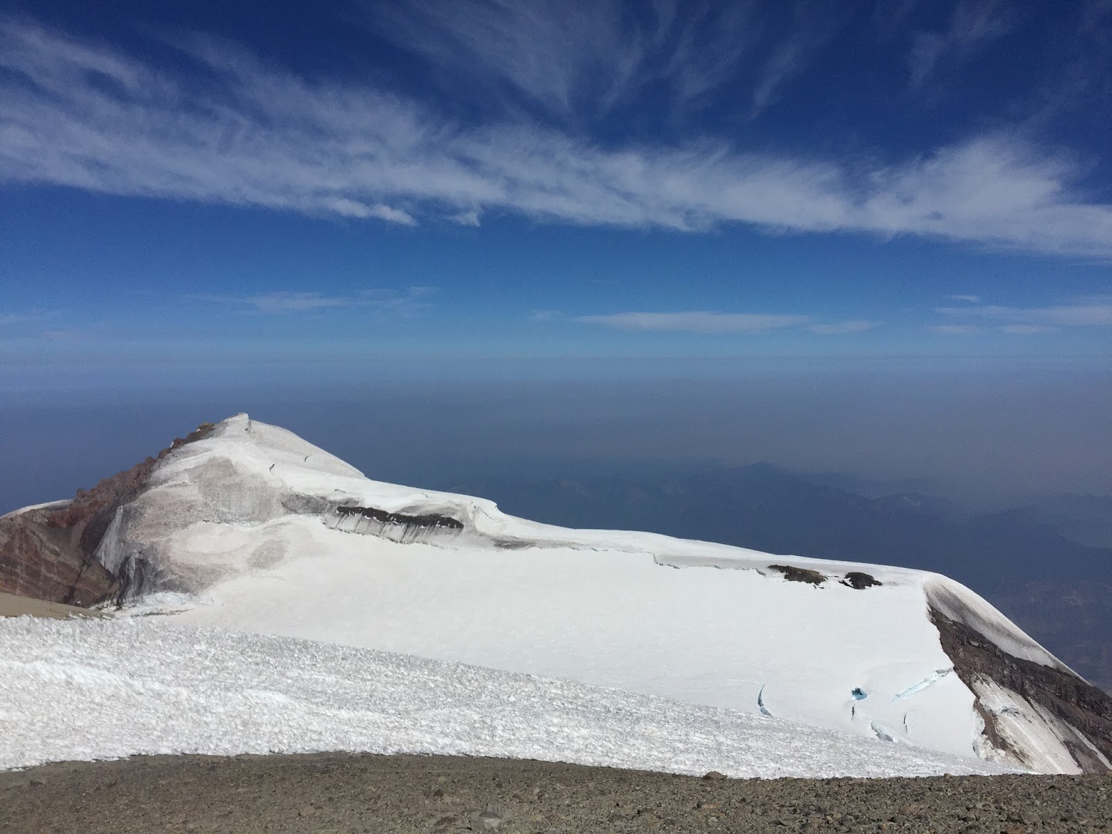
We have had unseasonably nice weather recently and this has not done the mountain much good in terms of climbing conditions. The rain event that started on Thanksgiving was warm enough to have that rain go all the way to the summit. This produced a think ice crust all over the volcano. A few storms coated the mountain with more snow and covered the ice but the recent high pressure and windy conditions have scoured the snow off the steeper slopes. That has resulted in large patches of exposed blue ice over much of the upper mountain.

Some photos from the Muir Snowfield and Camp Muir.


There are visible ice patches on Gibraltar Ledges and at the top of Gib Chute.


The Cowlitz Headwall with exposed ice all over.
So for now the upper mountain would be extremely difficult and hazardous to climb. Even moving around Camp Muir requires crampons. The weather pattern is shifting though and we expect more snow to start arriving on Friday.

Wednesday, December 06, 2017

Avalanches in Moderate Hazard

An avalanche was reported to have been triggered by two unidentified snowboarders on December 5th. The avalanche was large and could have easily buried and killed one or both of the parties. The avalanche occurred on a west-facing slope near treeline on Panorama Point. This area is easy to reach from the Paradise parking lot and is frequented by backcountry skiers, snowboarders and snowshoers.

One of the snowboarders was witnessed to have been swept into the avalanche and was deposited on the surface of the debris. The other snowboarder was not caught by the avalanche. Thankfully both parties were, apparently, uninjured and were able to self-rescue.

By the time rangers visited the site the following morning the avalanche path was reloaded with fresh wind slab and the debris pile was mostly covered with wind deposited snow.


The Avalanche Forecast that was issued for December 5th came out at 6:00 PM on Monday, December 4th. The Avalanche Hazard was listed as:
  • MODERATE Above Tree Line
  • MODERATE Near Treeline
  • LOW Below Tree Line
That may sound like a fairly benign hazard to many people, so how is it that a large sized avalanche was triggered on a day such as this?

The first thing to consider is that approximately 30% of avalanche fatalities occur on a day where the hazard is listed as Moderate. If you look at the definition of Moderate Hazard in the North American Danger Scale what you'll read is this:


It states that heightened awareness is necessary and there is the possibility of large avalanches in isolated areas and that it will be possible for humans to trigger them. So how could this slope have been avoided using the forecast? Let's take a look at what was said.

The very first thing written was:

The Bottom Line: There is less confidence in the forecast above treeline, due to limited observations. Travel with more caution if venturing to higher terrain due to recent heavy storm cycle loading through Saturday where wind and storm slabs may need more time to heal.

So already we know that large avalanches are possible and that more caution is needed when travelling in 'higher terrain'. If you were planning to venture above treeline in Mount Rainier National Park that would qualify as higher terrain.

If we look at the Detailed Forecast there were two very pertinent lines.

Fair weather with gradual warming is expected Tuesday with gradually increasing easterly crest level winds.
Watch for areas of wind transport and fresh wind slab deposits if easterly winds increase above forecasted. 
Now we know that we will need to watch out for areas where wind, from the east, will deposit snow especially at higher elevations and near ridge tops and that we should be even more cautious if the winds increase more than expected.

In hindsight we can see that the 'incresing easterly' winds deposited 'fresh wind slab' onto the west-facing slopes on Panorama Point right at treeline and so this isolated terrain feature was primed for a large sized avalanche. Unfortunately someone ventured onto that loaded slope and triggered an avalanche. Fortunately they were able to escape injury or worse.

This close-call can serve as a lesson for everyone and a reminder that Moderate Hazard still requires cautious decision making and appropriate terrain choices.

Saturday, November 18, 2017

Sunshine before the Storm

The sun finally broke through the clouds and Paradise felt almost like a beach today!  The upper parking lot filled up during the day with skiers, snowshoers,  photographers, and even some people just up for a picnic in a winter wonderland.  There were views aplenty of the upper mountain.  Calm winds and a warming air temperature trend made it hard to believe Thanksgiving is next week. 

Snow conditions varied with both aspect and time of day.  Wind from the last storm cycle came primarily from the southwest leaving wind packed and firmer conditions and about 3 inches of ski penetration.  The leeward northeast aspects had softer drifts and more variable, but deeper ski penetration.  Solar radiation started making noticeable changes midday, changing the fluffy drifts into mashed potatoes.

The forecast doesn't look good for skiers, the Mount Rainier Recreational Forecast says:

WINTER STORM WATCH IN EFFECT FROM SUNDAY AFTERNOON THROUGH
LATE SUNDAY NIGHT: 
Weak high pressure will give way to a vigorous front on Sunday 
afternoon and evening. 
SUNDAY...Windy. Mostly cloudy in the morning, then rain and snow
in the afternoon. Snow accumulation near Paradise up to 3 inches.
Snow level near 4000 feet. 
SUNDAY NIGHT...Windy. Rain and snow. Snow accumulation near 
Paradise of 4 to 8 inches. Snow level near 5000 feet. 
 
Extra caution should be used when recreating in the backcountry as a storm front like this approaches the mountain.  Simple equipment failures, navigation errors, and small injuries can lead to serious consequences when the weather turns for the worse.  Please remember that there's no ski patrol on Mount Rainier.  Rangers and Search & Rescue Volunteers are at least hours, and possibly days(!), away from reaching injured and lost parties and storms can prevent any search or rescue attempt.

Almost five feet of snow has accumulated in the Paradise area.  This is a great start for our base snowpack.  There's still some small trees and rocks sticking out, and creek drainages shouldn't be entered, but many of the smaller hazards are buried until spring.   

Check the Park's Twitter Feed for the latest on the road condition and closures and come on up for a visit!  Be safe out there and have a happy Thanksgiving!

Tuesday, November 07, 2017

Chinook and Cayuse Closed for Winter

Chinook Pass and Cayuse Pass on the east side of Mount Rainier have been closed for the winter season.  WADOT and the NPS consider the snowpack, the avalanche danger, and the weather forecast when making the decision to close the highways for the season, and it typically happens in mid-November.

Check out the park's road status webpage for more details.

It's also getting to be the time of year when the road to Paradise is closed at night for snow removal operations.  The park's twitter feed is the best way to track when the Paradise Road will be open on a daily basis. 

Saturday, November 04, 2017

Winter is Back!


On November 3 Longmire received it's first recorded snow for the 2017/2018 winter season and it looks like there's a lot more on the way. The UW GFS model shows anothher good hit of snow coming our way with significant accumulation.
Of course Paradise received considerably more snow than Longmire did and this is welcome news for skiers and boarders. We want to make sure that folks are taking precautions with all of the new snow we are expecting. The Northwest Avalanche Center has not yet begun issuing a daily forecast yet but it has issued a statement for the weekend. The one that pertains to the Paradise area can be found here.
Reading through it will give you an idea of what to expect if you're planning to travel above treeline, especially this:
Given the recent heavy snowfall in parts of our forecast zones, expect the potential for avalanches at higher elevations as conditions for storm slab and loose dry avalanches (primarily) will be present this weekend where anchoring is insufficient.

For more reading about early season avalanche hazard check out this short paper by Avalanche Canada.

Have fun out there but please be safe!

Saturday, October 28, 2017

Muir Snowfield and Summer Conditions in October

Low snow conditions still exist on Mount Rainier.

After a few good punches of cold precipitation skiers have begun spooling up for winter. The parking lot at Paradise has been filling up earlier and there's a lot more cars with ski racks and cargo boxes. Tales of skiing from Camp Muir all the way to Paradise have also been popping up online.

At the tail end of the big snow dumps we experienced a pretty good atmospheric river event with lots of wind as well as a lot of really warm precipitation. That event looks like it triggered a decent avalanche cycle from approximately 7,500' to 8,500'. The evidence that there was instability in the snowpack should serve to caution the early season go-getter's. It's not the worst idea to start your season out nice and slow and keep the terrain choices conservative.


A large crown and avalanche debris on Wapowety Cleaver.


The cycle has subsided now and in the past few days the sun has come out and temps have turned unseasonably warm. This has resulted in some nice corn skiing conditions on the Muir Snowfield. Today (Saturday, October 28) a ranger counted 72 skiers on the snowfield along with several hikers and snowshoers all taking advantage of the nice weather.

There is patchy snow from just above Paradise but the continuous snow does not start until above Pebble Creek (7,200') and so walking up and down from there is pretty much mandatory. This makes your footwear strategy hard to figure out. Running shoes or light hikers would be great to carry up but the trail is muddy, full of puddles and the snow patches are slushy. Low top shoes will get soaked. Hiking or climbing boots will keep your feet drier, of course they're heavy. The last option is to just walk in your ski boots but that is really tough on the feet and can put a lot of wear and tear on the gear. All three techniques were in full display on Saturday.

Above Pebble Creek the snowfield is fairly smooth with just a little wind effect here and there. The best skiing is between 10,000' and 8,000' with the lower stuff not freezing well overnight and staying slushy. The road will be open 24 hours a day until the next round of storms forces us to shut it down so take advantage of the ability to get an early start. It's probably best to start your descent before 1:00 PM to get good snow conditions. The late afternoon snow could be pretty tough to ski/board on.

Ski tracks in soft snow lead to the toe of the Muir Snowfield.

Just a note on climbing and skiing on the glaciers. With a light coating of snow and freezing levels at 14,500' this might be the most dangerous time of year to attempt to go for the summit or even get out on the lower glaciers. The crevasses that were wide open and obvious in September are now thinly veiled with a cover of slush and anyone choosing to climb or ski out on them is taking on a high degree of risk. It's a better idea to get your ski legs in shape on the mellower, non-glaciated slopes and let the mountain recharge with lots more new snow.

A snowboarder on the Muir Snowfield with the Nisqually Glacier in the background.

Have fun and be safe!

The Mount Rainier Climbing Rangers

Monday, October 02, 2017

Crisp Air and Fall Colors


The colors of fall have arrived at Mount Rainier.  With the change in color on the lower slopes comes change up high.  All of the climbing guide services on Mount Rainier have finished their summer operations and high camps are closed for the season with only occasional visits by the rangers.  Winter storms have blanketed the mountain with a thin layer of snow covering large crevasses and drifts forming hazardous cornices.  Climbers can expect very challenging, if not impossible, route conditions on the standard routes with the potential for dangerously cold and stormy weather.  Even day hikers and backcountry riders need to use extra caution.  Endeavors into the Mount Rainier Wilderness this time of year are much more serious adventures.  Always carry extra warm clothes, technology to navigate in a storm, and have a contingency plan.  

Check the Mount Rainier Recreational Forecast before leaving for your trip.  Remember that there's no gate that closes when the weather gets too rowdy - you have to make that decision for yourself and your team.  

Both the Longmire and White River Ranger Stations are open through October 9th.  Check out the park's Operating Hours Page for more info on seasonal closures.  Also, as the snow line continues to fall, the passes in the park will begin to close for the winter.  The park's twitter feed announces all the latest news regarding roads in the park and there's a Road Status Page that catalogues all of the changes throughout the year.  

Thursday, September 28, 2017

End of September Update, Caution for Skiers

 The season is rapidly changing here at Mount Rainier National Park. The guide services are winding down their season on the DC with operations running until about October 2nd. The guides have been able to re-establish the route to the summit but the forecast for the weekend is looking rather stormy.

UW MM5 model showing significant precip for the October 1st weekend.


A couple of the Rangers went up to Camp Schurman this past week to check on the hut and to check conditions. The first coating of snow seems to be sticking to the upper mountain but not below 10,000'.


Traces of new snow on the Emmons Glacier.

With the recent snowfall skiers have been chomping at the bit to get their turns in but we'd like to caution folks from striking out unroped on the glaciers when a fresh skin of snow has covered the crevasses. This summer was remarkably free of precipitation and that means lot's of open crevasses. Add a couple feet of fresh snow to hide them and a person travelling rapidly on skis or snowboard and you have a good recipe for a crevasse fall.

Tracks around thinly covered crevasses on the Inter Glacer.
We did have a near miss last week when a snowboarder fell unroped into a crevasse. That person was able to self extracate and evacuate, fortunately. The best bet for skiing this time of year on Rainier is to stick to the Muir snowfield but even that can have hidden hazards. Look forward to a long ski season by easing into it and wait for a few more storms to roll throuugh.

Saturday, September 16, 2017

DC Conditions and the End of Summer

Winter conditions have returned to Mount Rainier without much of a Fall transition. There has been snow as low as Paradise in the last 24 hours and the National Weather Service has issued the first winter storm watch for the season.

...WINTER STORM WATCH IN EFFECT FOR ABOVE THE 5000 FOOT LEVEL FROM
THIS EVENING THROUGH TUESDAY MORNING...

.TODAY...Showers. Snow accumulation at Paradise near 3 inches. 
Snow level near 5500 feet. 
.MONDAY NIGHT...Showers. Snow accumulation at Paradise near 9
inches. Snow level near 5500 feet. 
.TUESDAY...Showers. Snow accumulation at Paradise near 8 inches. 
Snow level near 5000 feet. 
.TUESDAY NIGHT...Rain or snow. Snow accumulation at Paradise near
5 inches. Snow level near 5500 feet.
.WEDNESDAY...Showers. Snow accumulation at Paradise near 4 inches.
Snow level near 5000 feet.
 
A snow level near 5000 feet is typical for Winter here in the Cascades. BRRRRRR.
 
The guided climbs from Sunday didn't even leave Camp Muir to attempt a summit bid due to the stormy conditions. The route requires a large degree of independence and technical proficiency as well and would be very difficult to navigate in white-out conditions. We strongly discourage climbing it in a storm. Above the Cleaver there is several hundred vertical feet of heavily crevassed terrain. The guides have been sending teams up to repair and reroute the path through this area every day for the past several weeks. There have been large collapses with climbers on route and parties without sufficient skill have become stranded on the mountain for short periods of time.
 
Climbing teams navigating a heavily crevassed area.
 
There are a few more storms in the forecast before things dry out again. For this reason and the complexity of the route we would advise against attempting a summit bid in the next few days. Consider changing your objective to focus on learning skills instead of going to the summit or even let the winter pass and climb when conditions are more favorable in the Spring. Remember that even a trip to Camp Muir can be extremely hazardous in low visibility.

Thursday, September 07, 2017

Conditions Update

The White River Entrance to the park is currently closed due to nearby forest fire activity.  Here's a link to the park's website with details on the closure.  The closure may be lifted with cooling temperatures and the chance of rain this weekend, but it may remained closed if fire behavior stays high.  The park's website has an Alerts and Conditions page that has the most up-to-date info.  

This means climbers should expect to register and climb through Paradise this weekend.  Check the previous posts for current conditions on the Disappointment Cleaver and Kautz Glacier.  Even with the added difficulty of late-season conditions, both of those routes have been climbed in the last week.  Be prepared to breathe some smoke and carry extra water for the unseasonably high temperatures.  The Emmons/Winthrop Glacier Route has not been climbed in over a week due to crevasses spanning the entire glacier mass.

The Climbing Information Center will be open this weekend, but it's the last two days of the season that it will be staffed.  After this weekend, climbers will be able to self-register at the Paradise Old Station.  Have a safe and hopefully non-smoky weekend!


Wednesday, September 06, 2017

Smoke on the Mountain.

The Wildfires of the PNW are causing  some very unusual conditions around Mt Rainier. Here are a few photos of the conditions from the summit  and Camp Muir. Smoke is expected to dissipate over the next few days with some cooler weather expected too.

-Sam Luthy  682

Looking to the south and the Muir Snow field. Mt. Adams in the Smoke.

East, toward Little Tahoma. 13000ft

Heavy smoke  layer looking down the Nisqually Glacier.

Liberty Cap in the Clear, but smoke filling the lower elevations.

Little T from Camp Muir on Wednesday 9/6. Empty Camp.

Monday, September 04, 2017

Labor Day DC Conditions

The Disappointment Cleaver Route has been all over the upper mountain this year, and September climbing is not an exception. The most recent route change, first mentioned on 8/31, has become established as the current best option to reach the summit. Instead of the taking a hard right of the top of the  DC and proceeding to the Emmons Shoulder, this route climbs above the Cleaver through broken and hollow terrain before traversing across the upper Ingraham to just above Camp Comfort at 12,800ft. This Ingraham traverse is very similar to conditions in 2015. Teams will have to negotiate steep terrain, two ladders and significant overhead hazard to make it through. Good time management is key and stopping for any length of time along this section should be avoided.  Once above Camp Comfort and climbing on to the upper Nisqually glacier the steepness and overhead hazards ease and the route traverses almost all the way to Point Success  and then to the  East Crater  Rim. Keep an eye out for hollow terrain and crevasse crossings thru here as well.  Total Route length is  3.5 miles from camp Muir.

 A main factor of this current route is its tenuous nature. Many of the current passages are thin and hollow and the  current hot weather is not helping. Teams should be prepared to potentially change route or not return exactly the  way they came. Stay tuned for any updates as more info from Rangers and Guides become available.

Making the top of Rainier is still possible this September. Come enjoy fewer crowds, and fall vistas on the Mountain.

- Sam Luthy  682

Hollow terrain just above  the Cleaver .
Double Ladder bridge.


Penitente Fields to the Summit


Thursday, August 31, 2017

Emmons Glacier and Inter Glacier Approach 8/31/17


Late season conditions seem to be the name of the game both above and below camp Schurman as September looms near. Of the few parties attempting to climb the Emmons-Winthrop week, only one was able to navigate to the summit and back. Even then, the team that topped out took nearly 15 hours round trip. All remaining teams turned around before the bergschrund due to loosing their way and not finding a viable route through/around large crevasses.


The route out of camp, up the Corridor and towards the Alpine Meadows continues much the same as it has, albeit with a few more open crevasses to navigate. It appears that the large, traversing crack at 12,400ft. which has held up all season, has finally opened up and is no longer passable. This is forcing climbers to head straight up the mountain around 12,100ft. At this point, the bootpack disappears and footing becomes a bit difficult due to penitentes, sun cups and sastrugi on the surface. Many parties that pushed up, into unfamiliar terrain, neglected to take a tracklog with their GPS and lost their way on the descent. Because of this, at least three teams got off route and had to ascend back up the mountain 1,500-2,000 ft. to get back on track.

This is no longer the time of year to head up the mountain without strong route finding abilities in complex glaciated terrain and a solid grasp up gps/tracklog functions. Without a bootpack, climbers are largely on their own. That being said, one party was able to find their way to the top of the mountain and back so climbers that have the necessary skill sets may still yet find success via the Emmons.


In other news, the Inter Glacier has been effected by snow just the same as the upper mountain and many moderately sized crevasses are continuing to open up along the approach to Camp Schurman. Climbers need to keep their wits as they ascent to the top of the prow and give these features a wide birth. The final climb into camp on the lower Emmons is also heavily crevassed at this point and teams need to rope up between Camp Curtis and Camp Schurman while on the glaciar.

Climbing rangers will be staffing Camp Schurman over the course of the next two weeks to work on some hut improvement projects for the fall. If you find yourself in camp, be sure to say hello and drop off any of that fresh fruit that you know they love!

- Safe Climbing!

DC Update 8/31

Here's a quick update before the weekend.

The guides have been extremely busy trying to establish a better route to the summit. As of now there are three viable paths. The first is described in our last update here. There is a variation to this route that avoids the long downclimb to the Emmons glacier but it isn't clear if this has been used by anyone other than a scouting party.

The third route was established 8/30 by a large team of guides. This route climbs the Cleaver and then traverses to the south towards Camp Comfort (the top of Gibraltar rock). It then climbs the upper Nisqually glacier to the crater rim. Today (8/31) will be the first day this route is operational for the guides. Stay tuned for more info over the weekend.

Wednesday, August 30, 2017

Muir Snowfield Conditions at the end of August

It's that time once again where sun-cups begin to grow deeper and the snow surface begins to resemble sand dunes.  The Muir Snowfield has a south facing aspect which means the sun-cups here are deeper and more defined than many other areas elsewhere on the mountain.

Looking down from Camp Muir.  Note the amount of dust particulate
on top of the snow.  These conditions are very difficult to navigate on
skis and cause damage to your ski/snowboard bases.
Currently there are still no crevasses on the snowfield, that being said, we are moving into early September which is by definition "Late Season".  If you plan on traveling up the snowfield and making the trek up to Camp Muir, keep an eye out for long sunken depressions running perpendicular to the boot pack.  These are good indications that open cracks are soon to come.  If you happen to see these features on the Snowfield, think wisely about where you step and refrain from blindly following the existing boot pack.  Snow conditions change on a daily basis, so what may have been stable the day before may have become too thin to support a weight of an a climber.  The bottom line: keep your eyes up and if a sunken line of snow appears in front of you that transects the boot pack, take a longer step to clear the feature.

Poor snow conditions near the top of the Muir Snowfield.  Note the wand for scale.

Example of an early stage crack forming.  Keep an eye out for these on the Muir Snowfield.

As you all may be aware, it's been very smokey around Mount Rainier, and the Muir Snowfield is no exception.  If you plan to trek up to Camp Muir, plan for decreased visibility as well as issues from exerting yourself with thick wildfire smoke.

Over the past weekend, we saw a number of folks hiking up skis and snowboards.  Most of them appeared to second guess their decisions and ended up walking their skis/boards down due to poor snow conditions and thin layer of sand and pumice on top of the snow surface.  We recommend waiting until the snow falls to bring ski gear up to the snowfield for risk of damaging yourself or your equipment.

As always, plan to pack lots of sunscreen, and more food and and water than you might think you'll need.  There is no water up at Camp Muir, so plan to bring enough for the trip up down the snowfield.

Sunday, August 27, 2017

DC update 8/27/2017

Late season conditions reign supreme on the DC. The route is long and there are numerous large crevasse bridges that must be crossed to climb to the summit. Most of the route's difficulties have been and continue to be above the top of the Cleaver (12,300'). Solo or unroped climbing is NOT recommended.

NPS Ranger Madsen climbing out of the Popcorn Bowl.
A 400' climb is still to come on the 'descent'.
The main area of concern for the guides is the 'Popcorn Bowl'. This is a heavily crevassed area where large seracs have all collapsed in giant blocks (the popcorn) and the blocks, crevasses and seracs are all shifting and moving constatly. The area is very reminscent of the Khumbu on Mt Everest. To top it all off there is a ladder lying at a 45 degree angle which get's you into and out of the popcorn. It's not a place to dilly-dally.

The rangers are more concerned with the length of the route and the fact that it climbs, descends, climbs, descends and then climbs and descends again. We normally refer to features by their elevation but the Popcorn Bowl lies at 12,500' and you reach that elevation 4 times while climbing Mt Rainier via the DC. The long and tough route is leading people to make some poor risk-management decisions. We have observed many teams takeing more than 15 hours for a Muir-to-Muir trip and even worse, leaving teammates behind and unroping from each other while on the upper mountain. It may be tempting to split up from a slower teammate but this is rarely a good idea.

The circuitous DC route of August 2017.


This is not the time of year to cut corners on your rick management and the rope is a key piece of that while climbing on glaciers. We'd much rather see people make safe and conservative decisions on the upper mountain as opposed to leaving teammates stranded or forgoing the rope altogether.
 

Tuesday, August 22, 2017

Climbing on the Cleaver

Well, the Disappointment Cleaver has been playing hard ball of late. Climbing rangers went up the route on 8/22 to assess conditions. And as reported in several previous posts, the problem zone has been just above the top of the Cleaver itself, with the upper portions of the route remaining similar to previous posts. There are two ladders in place, over a section that has been settling and falling into a large crevasse feature.

Ladder at approx. 12,700 feet
There have been relatively few groups making it to the summit in the past few days. One guided team was able to make it up yesterday (8/21), but it took the team approximately 14 hours from Camp Muir to summit and back. The combination of dealing with the ladders, and the length of the route has been causing longer than normal summit days for many teams. However, all of that said, the route is not closed! It is a matter of the level of risk each team is willing to accept. With proper belays, and rope technique it is possible to make it across the crevassed/ladder section above the cleaver. When making such decisions, it is important to keep in mind how warm the weather has been recently, as well as how rapidly the conditions on the upper mountain change this time of year. Just because a crevasse bridge felt solid when crossed in the early morning hours, does not mean that it is safe to cross in the warmer parts of the day.

Overview of the ladder and crevasse zone above the DC. 
As far as the rest of the route is concerned, the cleaver itself is almost entirely melted out. The recommended line of travel is to more or less follow the spine, or ridge crest, of the cleaver. And as always, be aware of teams travelling above and below you for rockfall. Stay tuned for updates as the route changes, and be sure to thank the hard working guide services when you see them for the excellent work they do maintaining the climbing route!

Monday, August 21, 2017

Schurman Side Conditions

Here are some pictures of the Inter Glacier and the Emmons/Winthrop route.  Camp Schurman was VERY quiet over the weekend. Rangers encountered one party of two between Friday and Monday.  That party of two was able to get to the bergschrund at 13,800 (where the DC and Emmons merge) on Monday morning but turned around due to time. 

View from Camp Schurman. 

With the DC route falling apart, the Emmons is probably the best route up Rainier right now (or the Kautz Glacier).  Be aware, however, that with so few climbers on the Emmons/Winthrop and late summer conditions, routefinding could be challenging and will require a higher level of skill than in the early season.  Certain sections are quite broken with many exposed crevasses. There probably won't be a boot track to follow and if there is, it could dead-end at an impassable crevasse.  And because of fewer climbers and the dwindling staffing of rangers at Camp Schurman, a climb on this side will require more self-sufficiency than in the height of the climbing season.  

Looking up toward the Inter Glacier. 


That being said, it's a great time of year to enjoy a quieter experience on the mountain.  The hike to Camp Schurman is currently very pleasant.   There are some deeper crevasses on the Inter Glacier but they are easy to avoid.  Just be cognizant on the way up and remember to watch out for them on the way down!  Be cautious descending the Inter.  Glissading is not recommended. Enjoy!

There are large crevasses on skiers right in this picture but they are difficult to see until right on top of them.  Beware!

Crevasses on the Inter.

-686

Friday, August 18, 2017

Emmons/Winthrop 8/16 GPS Track


It sounds like the crux is between Camp Schurman and Emmons Flats at the moment due to many crevasses.  It's been described as 'swiss cheese.'  The rest of the route appears to be pretty direct, but always assess the route as you go, don't just blindly follow the bootpack.  Climbing rangers are headed to Schurman Friday and will be there through the weekend.  We will post a more in-depth route description after our summit climb.
Image taken from a GPS track log of an 8/16 ascent by a former ranger.  

Tuesday, August 15, 2017

DC Is Back In!

It's not a groomed trail all the way yet and it's a little longer than it was a week ago, but after several days of hard work, the guides have the route going to the crater rim again. Be sure to thank them for all they've done when you come up.

It's important to note, it still passes over a number of large plugs and descends after reaching the top of the DC, and with the warm weather returning again we will see how long this version lasts, along with climbers' morale. The climbing rangers will go up on Wednesday to get a better update on the route, but for now, here at least is the kmz for those who are up to the challenge.


* Map: Google Earth representation of the tracklog of the route taken by the guides from Camp Muir to the summit today (8/15/2017).  Download the Google Earth KML file.

Climbing Ranger Updates on 8/16/17: The route still goes to the top and matches the above map. Be ready for it to feel exceptionally long with a number of switchbacks and small descents while trying to ascend. Guided groups are leaving around 11 PM to give themselves a little extra time.

Also, things are really starting to hollow out, so watchout for less than obvious holes, especially on the tight switchback after you descended 300ft from the top of the cleaver. Below are a couple of pictures of cruxes on the route. Watch out for the large crevasse near 13900 ft-there is a fixed line with a falling apart step to the left and an easier, thicker ramp up and over a wave on the right-climbing rangers chose the right option.


Always assess bridges before crossing them, especially as things soften up on your way down.

Leave No Trace In The Alpine

LNT is a term almost all backpackers and climbers are familiar with (if you have yet to hear of it, you have now and I recommend doing some further research to dial your systems to meet its principles). It is a set of seven principles that people follow in the backcountry to leave where they go looking as untouched as possible for future generations to enjoy the same wilderness experience. A number of the principles relate to your personal safety as well and will help you enjoy your experience in the wilderness.

From the impacts we have been seeing on Rainier lately however, it seems as though many are not familiar with how to adapt their LNT practices to the alpine environment, or they don't know LNT principles at all. Here's a run down of how to apply the seven principles on Rainier and other alpine areas.

1. Plan and Prepare
  • Do your research on the route, climbing permits, and climbing fees a head of time.
  • Know and practice your skills before you get on the mountain (from your layering system to navigating in whiteouts to crevasse rescue). Skills are perishable.
  • Bring a GPS unit or have it on your smartphone with the maps of the area already downloaded. Have extra batteries.
 
2. Hike and Camp On Durable Surfaces
  • Please don't hike on our beautiful alpine meadows, or camp on them. The flowers are beautiful and easily destroyed. Stick to dirt, rocks (though watch out for the lichen too), or better yet, snow (the least impactful surface).
  • Please don't camp next to water sources or go the bathroom near them! How would you feel if someone peed in your water source?
3. Dispose of Your Waste Appropriately
  • Pack it in and then Pack it out. This includes your food scraps, gum, and dental floss. We've been picking up piles of rice, granola, noodles, and chewed gum at Camp Muir and Camp Schurman. We have thousands of people passing through both camps every summer. How gross do you think camping there would be if even half the people left a small pile of food? Would you ever want to come back here if you saw that? It does NOT biodegrade up that high and in the snow. It just melts out and rots. We rangers work hard to keep that mountain clean, but we need your help.
  • Human waste: If you are not going in our toilets at the high camps, then you should be packing it out. You can't dig a cat-hole and bury it in a glacier and expect it to disappear forever. Guess what, it just melts out for others to see and accidently step on, and the rangers have to clean iit up. Again, thousands of people climb the routes on Rainier every year. Do you want to dodge piles of poop as well as crevasses? I doubt it. Rainier would become a biohazard in no time if people didn't carry their waste out.  Bring your blue bag or wag-bag and aim for the bag or pick it up after like you would your dogs' poop.  Bring extra blue bags so that you have enough.  There's no excuse not to pack out your waste. 
4. Take Nothing But Pictures
  • Millions of people pass through our National Parks every summer. It's so awesome to have people coming out and showing their support of our wilderness areas by enjoying them. But if even a quarter of those people took a souveigner from the mountains, meadows, or woods we would have less flowers, awesome small rocks/fossils, or pinecones for future generations to enjoy (and wildlife to eat!!). Snap a photo of those awesome things you see so that you can remember them later.
 
5. Minimize your campfire impacts
  • This one is simple in the alpine. No fires are allowed in the alpine. And good luck finding something to burn while you are up there.
  • That being said people sometimes do find things to burn in the subalpine and that is no good either. It destroys nutrients deep in the soil and it takes a long time to replenish for vegetation to grow there.
  • Do we also need to mention the fire hazard in many areas this year? Do you want to be the one responsible for starting a forest fire? Have fires only in officially designated areas and check if there is a fireban first.
6. Respect Wildlife
  • We want wildlife to live as they should in the wild and to be dependent on themselves. If they habituate to people, they become dependent on us, eat what they should not (get sick), and then starve in the winter months when no people are around and they didn't build their own stashes of food or forgot how to forage for themselves. Bears become agressive when they are habituated to people. They are then considered a "problem bear" and are sometimes killed because of it, even though it was really the fault of "problem people."
  • Moral of the story? Don't feed wildlife, whether it is directly from the nuts in your hand or the food scraps you left at camp.
7. Respect Other Visitors
Super important, especially when climbing in the alpine and here's some tips to make your climb (and others') more enjoyable.
  • Watch out for bottle necks on routes-try to space yourself out from other parties when leaving camp on busy nights.
  • Be careful when traveling on loose rock (keep your rope short) so you don't knock rocks off onto other people or knock rocks onto yourselves.
  • Be self-sufficient and prepared when you come on Rainier so you can prevent an incident. If things do go south, have the skills and equipment to care for yourself and teammates so you don't pull other people into your incident and endanger them.
  • Parties late into the night at the high camps? This is inconsiderate to those who need to get up early for their climb.
Please, help us keep our mountains looking pristine to provide an awesome climbing experience for all to have.