Tuesday, July 31, 2018

D.C. Route Update 7/29

The only thing that is consistent on the D.C. this year is change. With the recent warm temperatures the route has been evolving rapidly. Where there was once multiple options to navigate through broken up sections there are now only paths with significant exposure to hazards.

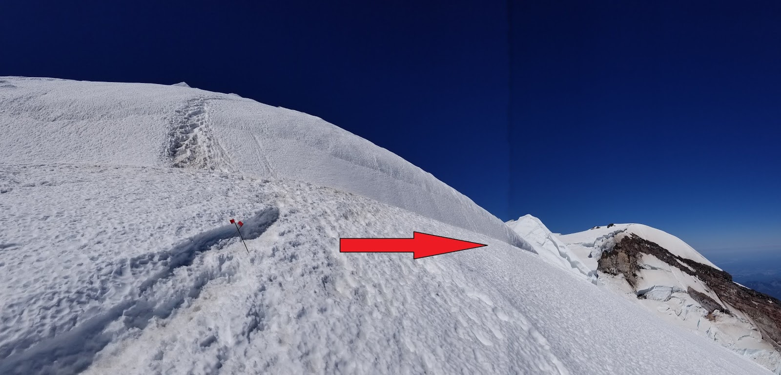
The main area of concern is 'The Popcorn' at 12,500 feet. Popcorn is a reference to large blocks of ice stacked up with little support. If one block shifts, all the other ones move as well. This particular popcorn section sits above a large crevasse cavern and thus is not supported from below. Climbers entering the Popcorn expose themselves to both the potential for ice fall from above and for the route to collapse underneath them. Either of these would be an unsurvivable event.

For those that have been following this blog, the 'plug' discussed on the last update has collapsed into the crevasse cavern and the route now travels ~150' further uphill.


Photo of the Popcorn section. Note the large cavern below the ice blocks.


This is a typical low-probability, high-consequence risk management problem. Each climber needs to decide if they choose to accept this risk or not. The rangers at Camp Muir have been instructing climbers to look at the feature for themselves and have a discussion amongst their team about the risk. If any member of the team decides that climbing that section is too hazardous, the whole rope team should respect that decision and descend. Approximately one-third of the teams that make it to the Popcorn have decided that the risk is not acceptable and they have retreated from that point.

A ranger climbs through the Popcorn
 

Additionally, if this area collapses while you are above it, returning to camp will require several thousand feet of extra uphill climbing. The only other known option to return to Camp Muir involves climbing back up to 13,500' and descending to Camp Comfort at the top of Gibraltar Rock. From here, you will have to follow an old, unmarked trail to get back to the Disappointment Cleaver. If you are planning to climb this week, be ready for things to change rapidly and have a reserve of energy to overcome these potential challenges.

Approximate climbing route as of July 29, 2018.

With all the discussion of the route finding issues it's important to note that other hazards still require attention. Rockfall hazard exists in Cathedral Gap as well as getting on/off the base of Disappointment Cleaver. Climbers have been injured by rockfall this summer. Crevasse fall is, of course, an ever present concern on the glaciers as well.

It's important to come to Mt. Rainier with a good understanding of the risks inherent in mountain climbing and the hazardous areas unique to the D.C. route.
 

Monday, July 30, 2018

Emmons Update - July 29, 2018

Here is an update for the Emmons/Winthrop route.  The bulk of the route information is similar to the last blog post.  You can follow this link to access that post.

The main area of concern for the rangers continues to be the bergschrund at 13,200'.  Here the old trail crosses this large crevasse on an ever-shrinking snow bridge.  The old trail is still the easiest to discern but PLEASE DO NOT GO THIS WAY!  This snow bridge looks like it will collapse very soon.  If it collapses while a team is on it the consequences will be catastrophic.

This is the snow bridge that we would like climbers to avoid.

Instead, at the junction at 13,200', look for a fainter boot pack that will take you up and right  (northerly) toward Winthrop Saddle above the upper Winthrop Glacier.  This is the safer route. 

Fork in the road.  13,200'.  You want to go right here, toward the ranger. 
There are still many hollow spots along the Corridor, so use caution.  On Sunday there was a report of an independent climber falling in a crevasse.  Fortunately the individual was uninjured and his partners were able to extricate him.  This is the second reported crevasse fall on the Emmons in two weeks.  In both cases the team was able to self-rescue.  This is commendable.  Parties attempting any route on Rainier must have the equipment and skills to perform crevasse rescue.

Lastly, PLEASE DON'T LEAVE TRASH AT CAMP SCHURMAN (or anywhere on the mountain).  Climbing rangers were a little dismayed at the amount of stuff abandoned near the hut when they arrived Friday.  There was a foam sleeping pad, trash bags, a coffee mug, trash in the bear box which is used for food storage near the hut, etc.  Please remember to pack out all that you pack in to the mountain. 

We're definitely entering late season on the mountain.  Come get it while it's still good.

Thursday, July 26, 2018

Last Weekend in July Update..


Both the Disappointment Cleaver and Emmons/Winthrop Routes have been changing, almost daily, due to shifts in the glacier.  The high freezing levels and uninterrupted sunshine have been cooking things on the upper mountain.  Both of the most recent blog posts for these routes outline the gist of where the route goes and what to expect, but be aware that it can change at anytime.  We encourage climbers to start early on these warm days and stick with an early turn around time to help avoid being in the most hazardous areas during the hottest part of the day.

The weather forecast has a bit of a blip coming up this Friday and Saturday:

.FRIDAY...Sunny. A slight chance of thunderstorms in the
afternoon. Snow level near 12500 feet. 
.FRIDAY NIGHT...Partly cloudy. A slight chance of thunderstorms
and snow showers in the evening, then a slight chance of
thunderstorms after midnight. Snow level near 12500 feet. 
.SATURDAY...Mostly sunny. A slight chance of thunderstorms and
snow showers in the afternoon. Snow level near 12500 feet.  

Be cautious ascending high on the mountain with thunderstorms in the forecast.  They often move over the mountain faster than climbers can descend and can cause a potentially dangerous situation.  Don't climb up into a thunderstorm and if you see thunderstorms approaching the mountain or beginning to build nearby, consider descending back to camp or the parking lot.  It's best not to be the tallest thing out on a wide open snowfield.

July has flown by!  It's starting to be a bit quieter on the mountain, but we still encourage folks to come during the weekdays if possible to avoid the crowds.  Talk to the rangers when you register for your climb about the latest in conditions.  See you on the mountain!

Monday, July 23, 2018

Emmons-Winthrop Update 7/23


The Emmons-Winthrop route remains in typical late July condition. Many crevasses in the Emmons Flats and Corridor areas sport thinning snow bridges and the route is growing more circuitous by the day. The bulk of the route remains unchanged from the previous posts; the route trends climber's left above the Corridor through a large bowl. Expect to make decisions regarding the best route for your team during your attempt.

Light blue indicates the most recent route to the Winthrop Saddle.
The bootpack is quite narrow in places—especially on steep traverses—and it requires careful footwork to avoid catching a crampon on your pants. The consequences of a fall in this terrain are significant. Move slowly and deliberately through this terrain; some parties may wish to use running belays to increase their security.

The bergschrund is on its last legs. Climbing over it is the steepest section of the older route.  It spans roughly 30 feet and the bridge is a mere three feet thick in places. Rangers were able to establish an alternate route to the summit rather than crossing this terrifying feature.

The old boot pack takes you over this....

This option traverses to climber's right (toward Liberty Cap) below the bergschrund and weaves its way through a small trough and open slopes out to the Winthrop Saddle at 13,600'. This recommended option approximates a common path that the Emmons-Winthrop route has followed in previous seasons. The bootpack is currently difficult to discern in this section and is not wanded.

Trend Right.
As July rolls on into August, expect the glaciers on Mount Rainier to continue to present more challenging climbing conditions. Be prepared to navigate complicated terrain, perform crevasse rescue, and give yourself more time overall to complete your summit attempt.

Sunday, July 22, 2018

D.C. Route Update -- 7/22

Ingraham Flats with the Disappointment Cleaver on the right.
Few climbers managed to reach the summit via the Disappointment Cleaver on July 22nd. This was, in part, due to reports from returning climbers early in the day that the route had changed overnight. There were also reports of a bottleneck at a glacial plug around 12,400’--near where climbers leave the top of the Cleaver and climb through a frequently-hollow section of glacier. 

Plug at 12,400' with overhead icefall hazard that is constantly present on the DC route
The morning light allowed a more thorough assessment of the plug. It is possible that some of it had collapsed overnight--what remained intact was narrow, but moderately thick. Nearby glacier features, like thin fins of ice, give the appearance that the plug is poorly supported. With the high freezing levels in the forecast, there is no telling how soon this snow bridge will fall out. Remember to practice conservative decision-making in the mountains and this situation is no exception; it is not advisable to cross tenuous features in late morning or early afternoon conditions once the sun starts softening snow.  For the moment, this route remains a viable option in somewhat typical July condition, excepting weakening snow bridges like these and other hazards inherent in the mountains.

Looking up from the top of Disappointment Cleaver. Note the icefall debris on the left and the crevassed jumble on the right.

However, with this partial collapse and the increasing potential for rapid changes, the guides at Camp Muir have begun talking about other options. Who knows where the route will go as the summer presses on?  Guides are hopeful that the debris from the collapsing bridge and surrounding seracs will eventually fill in the crevasse at 12,400' and allow the route to follow a common summertime path out to the Emmons Shoulder.  If the gaping crevasse doesn't fill in with debris, the guides will likely have to completely rework the route. Time will tell.


Plug at 12,400' from another angle
Please understand that if this bridge fails while your team is above it, your descent to high camp will be a long journey. There is no easy workaround if you return to this bridge and it is no longer passable. In fact, if the bridge collapses while you are above it, returning to camp will require several thousand feet of extra uphill climbing. The only other known option to return to Camp Muir involves climbing back up to 13,500' and descending to Camp Comfort at the top of Gibraltar Rock. From here, you will have to follow the old trail (no markings, wands, ladders, or pickets) and make your way across the recent ice fall debris on the Ingraham Glacier to get back to the Disappointment Cleaver. If you are planning to climb this week, be ready for things to change rapidly and to have a reserve of energy to overcome these potential challenges.

Climbing Ranger descending to the top of the DC

Friday, July 20, 2018

Disappointment Cleaver Route Update -- July 20th

The new route variation (blue) on the Emmons Shoulder.
As the freezing level continues to stay near or above 14,500 feet, the glaciers on Mount Rainier continue to change as well.  Guides recently put in a new variation that directs climbers up towards the "Emmons Shoulder" from the top of the Disappointment Cleaver.  All of the wands and pickets placed on the older variation of the route have been pulled.  If you choose to climb the older route be prepared to navigate with a GPS, and protect the steeper headwall terrain and major crevasse crossings. 

The new option avoids the major ice fall zone that occurred on the Ingraham Glacier a couple of weeks ago, but doesn't eliminate all of the overhead hazard.  There is still potential for ice fall onthe new variation.  Keep an eye out for looming ice cliffs above and don't linger or take breaks below these hazards.

Rockfall near Cathedral Gap has also been active at all hours (including in the middle of the night) due to the warmer temperatures.  As climbers finish crossing the Cowlitz Glacier and gain the rocks at Cathedral Gap, the transition from glacier-travel mode to rock-travel mode stalls them directly beneath the hazard.  Prepare your team ahead of time for this roped transition; make necessary rope adjustments out of the rockfall hazard zone and pass through quickly.  It's also worth taking a break, getting a snack and a sip of water, before crossing the hazardous area so that everyone can move their fastest if needed.

Overall, the Disappointment Cleaver route seems to be in late-July conditions. It will continue to break apart and become more circuitous as the summer goes on.  The high pressure and sunny skies that settled in a little over a week ago remains in place and has made for great weather conditions on everyone's summit day.  And, lastly, it's still the busiest time on the mountain; consider climbing during the weekdays through the rest of July and early-August to avoid the crowds.

Wednesday, July 18, 2018

Inter Glacier and Emmons Conditions - July 17th, 2018

Here are some pictures of current conditions.  The best route up the Emmons Glacier, and the one being used most frequently over the past few days, is still ascending up and climbers' left of the "Corridor" through the "Garbage Disposal" before traversing right at around 13,000 ft to tie-in with the older boot track.  More information on this route is here:

http://mountrainierclimbing.blogspot.com/2018/07/emmons-update-july-15th-warmer-temps.html 

While the "Garbage Disposal" avoids many crevasses, it is steeper and subject to icefall.  Be sure to ask if this overhead risk is worth it for your team and consider how long you will be exposed.  Additionally, there are many crevasses opening up right out of Camp Schurman and near Emmons Flats.  The Corridor is also quite crevassed and there was a report of at least one team member experiencing a roped crevasse fall on Monday morning.  If attempting this route in its current condition be prepared for route finding and crevasse rescue.  It is in late-season condition.

The Inter Glacier is also entering late-season condition and features crevasses along the bootpath which are difficult to see until you are right next to them.  Glissading is not advised and roping up is not a bad idea.

The Emmons-Winthrop from the top of the Prow.  

Crevasses on the Inter Glacier.  The boot pack goes right next to these with more on the other side.  
Looking up from Glacier Basin. 


Sunday, July 15, 2018

Emmons Update - July 15th: Warmer Temps Taking a Toll


First morning of wildfire smoke this season.
It seems that the high pressure of summer has finally arrived and with it so have the climbers and rapidly changing route conditions. Throughout the weekend, nearly all camps were booked with climbers: from Camp Schurman and the Emmons Flats, to Camp Curtis and the Inter Glacier bivies. As we continue to roll through July & August peak season here at Mt. Rainier, climbers should show up with some flexibility to their plan and perhaps a backup option or two. That being said, many groups were up on the mountain this weekend and a few teams had successful summit attempts despite heat and somewhat deteriorating conditions of the route.

Approach route onto the Emmons from Camp Curtis continue
to melt out rapidly with high temps this week.
With a rapidly depleting snowpack all over the mountain, the Inter Glacier and the approach route off the Camp Curtis ridge and onto the Emmons is melting out quickly. As of yesterday, climbers are now avoiding the obvious line in the photo and are dropping in/exiting the Emmons slightly downhill in order to avoid the steeper, slabby and exposed rock scramble. Rangers have been happy to see that nearly all parties are roped up as they come into camp. Perhaps it's only due to the more broken nature of the Emmons this year, but that section of glacier is heavily crevassed and certainly warrants the deployment of ropes, harnesses, helmets, axes and crampons (full glacial mode). Once in camp, climbers can expect to share space with many other eager climbers so camp etiquette and hygiene are paramount.

Full camps are a theme throughout July/August peak season.

 In terms of route conditions, the steadiness/reliability that we saw on the Emmons throughout much of the early season has finally begun to deteriorate. Arriving in camp on Friday, rangers received reports from both guides and climbers alike of a hollow route from top to bottom that was difficult to protect. Reports of large, sagging, "team eating" bridges, postholling into blackness and unnerving, soft snow conditions gave rangers enough reason to try to find an alternate route up the mountain.

Climbing rangers scouting a new re-route for the Emmons
between 11,400' and 12,600'.

 Although rangers were able to climb via a different route between 11,400' (top of the corridor) and 13,600', the steepness and exposure of the upper pitches didn't make it an ideal alternative to the current bootpack. That being said, a variation to traverse back into the main boot pack around 12,600' still cut out nearly 1,200' of the most hollow section of track. As of Sunday morning, there was a mixed-bag of attitudes in high camp. Many parties decided that the warm temperatures and objective hazard was simply too high-risk and stayed in camp. Some parties attempted the old boot pack today and all of them turned around due to the sketchiness of the crevasses all around. Finally, a few more experienced parties were willing to attempt the new re-route and some of them had success to the top. Most folks that have been able to summit have been topping out by sunrise and returning to camp by 9 or 10 am to beat the heat. 


Track log from the re-route on the Emmons. Green route is new,
red line is the old, most hollow section of the route.


Topo of the new re-route. Cutting out the old bootpack (in red) avoids a large section
of hollow terrain between 11,400' and 12,600'.

No matter what choice you make if deciding to climb the Emmons, rangers are stressing the importance of personal risk assessment and risk management amongst groups as they show up in camp. As of now, the route is no longer the "cruiser,"  stable route that we often expect earlier in the year. For parties with solid mountaineering experience, including excellent comprehension of crevasse rescue, running belay/anchor belay and glacial navigation techniques, the Emmons might be a great challange under the current conditions. For parties with minimal mountaineering experience and less confidence in unstable glacial conditions, the current Emmons route might offer too much hazard/risk. Even with a new re-route there is still a lot of uncertainty/risk from the first crevasses encountered out of camp all the way to the nearly 75' overhung bergschrund curtain that the route passes directly over at 13,600'. Successful and safe passage up the current route will require a full repertoire of skills from belay techniques, route finding (it will undoubtedly change daily as things continue to melt out this week), fitness and the ability to ascend and descend by early morning.

Thursday, July 12, 2018

Disappointment Cleaver Update -- July 12


Looking down the icefall debris on the Disappointment Cleaver route. Note climbers for scale.

The path of the Disappointment Cleaver route remains largely unchanged over the past few weeks.  The route still climbs up and left from the cleaver to the top of Gibraltar Rock before continuing up to the crater rim. This may change as guides work to re-route the path in coming days and weeks to reduce exposure to serac hazards and as the crevasse crossings along the route widen.

Looking across the Ingraham Glacier toward Camp Comfort. Note icefall debris and leaning seracs.

Crossing the icefall debris.
The biggest concern this week has been objective danger from serac fall on the route coming from the upper Ingraham Glacier. There have been two very sizeable ice falls starting at around 13,000 feet, resulting in a debris field that is a few hundred feet wide and roughly 1000 feet long.  Many parties are choosing to not subject themselves to this hazard by stopping their climb atop the cleaver at 12,500 feet and deciding to come back another time.  If you choose to climb through this section, move quickly and DO NOT STOP until well away from any overhead hazard.

Rockfall below Cathedral Gap.
With warming temperatures, the large rockfall debris near Cathedral Gap is becoming increasingly dangerous as the snow pedestals holding boulders begin to melt out. Above freezing temperatures at night mean that these behemoths may fall at any time of day. Move swiftly through this area.

Ladder at High Crack.
 A pair of short ladders were installed on the route this week, across widening crevasses. If you feel the ‘need’ to jump across a crevasse, look for an alternate route. There is no reason to take flight during glacier travel, contrary to what many books and social media posts may portray. Ankles and knees rarely take the hard landing well and many injuries result from being airborne - especially when wearing crampons. 

Be sure to practice Leave No Trace while on the mountain. Blue bags can be obtained at the ranger station when you get your permit; use these any time you are not at a bathroom. The bags can be deposited in labeled barrels at Camp Muir and in Paradise (not in the toilets). Do not leave your human waste along the climbing route for others to see or clean up!

July crowds to the right and icefall debris to the left.
It’s shaping up to be another busy July weekend on the mountain. Plan ahead to obtain your climbing permit (even for single-push attempts), be courteous to other climbers, and make good decisions for yourself and your team.


Disappointment Cleaver Route Track Log taken on July 11.

Kautz Route Update

Rangers climbed the Kautz Glacier route this week and were pleased to find pleasant climbing conditions. The Kautz route is more technical than both the Emmons and DC, however, it remains a good stepping stone for those contemplating more challenging objectives on Rainier.  The route requires a higher level of technical skills in order to negotiate the rock step, technical ice chute, and glacier route finding. Rangers ascended from Paradise to Glacier Vista, then descended toward the Nisqually Glacier.  This approach was still mostly snow covered. 

The route taken on 7/10 to a bivy site near the Turtle Snowfield.

There are two common ways across the Nisqually; one heads toward the "Fan" and the other traverses a little higher towards the Wilson Glacier "Gully" just above. Rangers opted for the Gully approach as the Fan is quite melted out and the crevasses on the Nisqually Glacier crossing didn't prohibit access to the upper ridge. Remember to rope up for these glacier crossings, and take a GPS track once you leave the trail in case clouds roll in and visibility deteriorates during the climb.

The Wilson Gully approach from the Nisqually Glacier.

Above the Wilson Gully, rangers ascended the lower Wapowety Cleaver to The Castle at 9600 feet.  Many good campsites exist in this area between 9,400 and 9,800 feet, in the vicinity of The Castle. Other bivy sites can be found near the top of the Turtle Snowfield around 10,800 feet. Rangers found running water near both The Castle and the 10,800 bivy site.  

Shortly after departing camp the next morning, rangers arrived at the rock step.  Currently, a 25' rappel is necessary to negotiate the rock step and access the Kautz's ice chute.  Old, tattered fixed ropes mark the top of the rock step.  As with all fixed equipment, the fixed lines should be inspected for core shots or damage before use. Be prepared to back up any gear you encounter and use your own ropes/equipment if you doubt the quality of fixed gear. The ice chute is sun cupped from top to bottom.  The snow pinnacles offer good security, but don't hesitate to utilize running belays or pitch out the terrain. Decent alpine ice can be found near the top of the chute to the left or right of the gut.

Looking down the Kautz ice chute.

From the top of the chute, meandering glacier travel brings you to the Wapowety Cleaver at 13,000 feet. There are a couple small exposed bivy sites on the Wapowety Cleaver, but no running water.  From the Wapowety Cleaver, a few long switchbacks bring climbers across the upper Nisqually Glacier to the crater rim.  The upper glacier is in good condition and smooth. A few large crevasses in this section have thin snow bridges, and it may be a good idea to belay your partners across these crevasses.

The route taken to the top from high high camp on 7/11/18
If you're planning a climb on the Kautz, grab some blue bags from the ranger station at Paradise or Longmire when you get your climbing permit. Wherever you decide to bivy, be sure to keep camp clean and pack out any trash you find.

Monday, July 09, 2018

DC Update: Objective hazards become palpable

Ice fall debris with Gibraltar rock in the distance. Photo: Tyler Jones 

This morning guides reported seeing debris from a large ice fall on the upper mountain.  The large ice block tumbled in the middle of the night when no parties were on the route. The event occurred at approximately 12,600 feet on the Ingraham Glacier, just above the top of Disappointment Cleaver. Ice blocks tumbled over the climbing route and continued down the glacier at least another 1,000 vertical feet; simply put, this would have been an unsurvivable event.  The route through this area will be more difficult (and slower) to travel across with the new debris and uneven footing.


Ice fall debris over the route above the top of Disappointment Cleaver.  Photo:Tyler Jones

Events like this are a good reminder of why it is important to be aware of the objective hazards on the route, and to minimize your exposure to them. Move quickly through zones that are underneath seracs (and rockfall), and keep your senses tuned for the sound of tumbling ice blocks. More seracs in this same area could fall in the future as the glacier continues to move downhill.  It is impossible to predict when this might happen. Any serac that is tilted downhill and disconnected on the uphill side could tumble at any time. Have a discussion with your team members about your strategies for moving though areas subject to ice fall and don't linger in these areas.

More ice could fall from the same area on the Ingraham Glacier
 above Disappointment Cleaver. Photo: Tyler Jones

The rest of the DC route remains unchanged.  We have entered peak climbing season in the Muir corridor, and the route will tend to be crowded on weekends.  Remember to stay courteous and friendly with other climbers you encounter on route, and keep the mountain clean!

Emmons-Winthrop Route Update

Climbing Rangers ascended the Emmons-Winthrop on July 7th and were surprised to find that the route remains very direct, but is trending toward late season conditions. The route was only 2.5 miles long from Camp Schurman to the summit, zig-zagging through a jumble of cracks directly above the Corridor before angling up and right above a giant rectangular serac.  That being said, this could change at any point, and expect it to with the really high freezing levels that are coming in this week.

Giant rectangular serac illuminated by the sun.


The points we took away from our climb and want to spread to other climbers:

1. Crevasse fall potential is high. Use protection on larger crossings, especially if the slope is steep and a fall could drag your partners into the crevasse too. When temps are so high, get up and down early. When crossing something big, how can you get back below it if that bridge collapses while you are above?  Keep a look out for alternative routes.  

There were a couple of large bridges we crossed (around 13,100' and 13,500') that had steep headwalls on the uphill side.  Arresting a fall on the steep headwall if the lower person broke through would be impossible.  Place a picket on the uphill side of the crevasse after the leader crosses to have it between rope-team members (running protection). In the warmer temperatures that are coming, consider a full belay for crossing the larger bridges.  

Steep headwall above a hidden crevasse.  It's hard to assess how thick and strong the snow covering the crevasse really is.
A climbing ranger having just crossed a 20 foot wide bridge to a picket and the steep headwall on the uphill side
2. Take a GPS track on the way up. If you climbed the DC before and expect to find the Emmons Winthrop as easy to follow and straight forward, you will be very disappointed and ill prepared. This is not a maintained route. Don't expect the bootpack to be easy to follow or to always go the best way. Don't blindly follow tracks across areas that you are not comfortable crossing. And if clouds roll in, finding your own way down can be nearly impossible in a whiteout. Have a GPS, download the maps for Mount Rainier, and know how to use it.

3. Stick with your climbing partners. Again, STICK TOGETHER.  As climbing partners, it's your duty to look out for each other. If one person is feeling run down or showing signs of AMS, you should all turn around together. Don't leave your buddy sitting on a glaciated slope while you "quickly" tag the summit. As you head down from Schurman, it's good to keep your partners within visual distance, at least to Glacier Basin. People have fallen in the cracks on the Inter Glacier and if no one witnesses a fall, it can be hours before help could arrive.
Large Crevasses right above and below Camp Schurman
4. Be courteous to other climbing groups. The mountain is always busy in July. The camping and climbing use quotas (read: limits) for the standard routes are filling up fast. This means a lot of climbers on the routes. At some point you will pass every group on the route and remember, if you are feeling 'hangry' or tired, and sore, they are probably feeling just as bad as you. And everyone's day can be a lot safer and smoother if you just communicate with other groups (Are you crossing a crevasse now? Heading up or down? Taking a break in a safe zone, out of the way of other parties?).  And maybe even try to share a smile with folks.

5. Know your own limits (and your group's) and stick to them. Stay well within your abilities.  Don't get summit fever. If you come across a crossing you are not comfortable with and don't see an alternative, don't do it. The route is getting toward late-season conditions and requires increasing amounts of experience and skill to navigate. You can always come back another season with more experience and knowledge under your belt. 

Thinking about skiing? Check out this link.

Be safe out there and have a fun climb.


Friday, July 06, 2018

Busy Weekend = Full Camps

Hey everyone,

We figured this was going to be a busy weekend!

The high camps have filled up for Friday and Saturday nights already.  Here's how it breaks down:

There are 110 people allowed at Camp Muir each night.  There are 48 people allowed at Camp Schurman.

Camp Muir & the Muir Corridor

Currently, Camp Muir is FULL Friday, July 7th, and Saturday night, July 8th.  Even for walk-up permits.  The only chance of getting a permit is if someone comes down early from their climb and checks out at the desk so that we can avail the numbers in the system.  Don't count on it.

Common overflow areas for Camp Muir are the Muir Snowfield and Ingraham Flats.  There are 36 people allowed at each of those spots.  Right now the system showabout 5 open spots for those areas.  You could conceivably walk up today or tomorrow and get one of those spots, however, this does make the climb longer from the Muir Snowfield (below 9,700').  And it is more difficult to go all the way from Paradise to Ingraham Flats in a day.  That's a long way.

Camp Schurman, the Inter Glacier, and Emmons Flats

Camp Schurman still has 15 or so spaces for Friday, but Saturday night is completely full.  Sunday looks better at this point.  Emmons Flats already has 15-20 folks both Saturday and Sunday night.

If you really want to climb Mt. Rainier this weekend, Camp Schurman is going to be your best bet, and you want to get to White River to register first thing.

I'm sure that will change by the end of 07/06 (today).

Single Push Climbers
Often climbers seeking to avoid camping restrictions try to climb the mountain in a 'single push.'  Single push climbers count toward the tally of total climbers on the route, even though they are not setting up camp. As such, single push permits WILL NOT be issued if the high camps are full.

Resource Protection and Visitor Safety

The current limits on campers at each camp each night has been in place for a few decades.  These numbers represent the maximum limit of people that each area can handle with regards to resource protection and visitor safety.  For example at Camp Muir, when we have more than 110 people camping, the number of climbers on the route gets so large that it becomes unsafe.  Rockfall from climbers above, long wait times at pinch points or technical crossings or ascents become untenable, as well as lines for the bathrooms (and managing the human waste collection systems) can all reach emergent conditions.

To ensure and satiate your desire to plan, we recommend that you submit a reservation.  Roughly 60% of the total of each zone or camp can be reserved.  40% are reserved for walk-up permits.

Reservations

To make a reservation for the coming weeks, please visit the following site.  We recommend this every weekend from here on out.

Google Form for Climbing Reservations

Thursday, July 05, 2018

“K” Spire Trip Report July 4th, 2018


Climbers approaching K Spire from Meany Crest via the Frying Pan Glacier

Earlier this week, rangers had the rare opportunity to head into the backcountry for a patrol that entailed rock shoes and cams rather than double boots and ice tools. With relatively limited intel on the quality of rock or route descriptions, it made for an enjoyable climb that felt a bit more "wild" than the likes of the standard routes on Rainier. Similar to the Little T approach across the Frying Pan, climbers found the glacier to be in good shape which made for easy navigating towards the spire.

Upon reaching the base of the ridge, the lack of climbers trails or bivy sites reaffirmed the limited traffic this spire receives. A quick climb up the talus gains you the ridgeline just to the west of the spire. Upon closer inspection, it became clear that the NW corner and North Face of the spire are flaky, exfoliating and of poor quality. Additionally, the rock on the South Face seemed to improve dramatically the higher you got up the face. Although rangers climbed the South face via a 3rd class ramp that put you into the better rock, a few other routes could easily be climbed depending on your willingness to deal with poor rock down low. A blocky dihedral system on the SE corner seemed like a viable option after pushing through 20 ft. of rotten rock. Additionally, there were a few variations from the top of the 3rd class ramp that might go between 5.7 and 5.11. 

After scrambling up the ramp, climbers roped up and began working up and right through broken blocks, slab, a high step (5.9) and eventually into a short chimney section that gained you access to the summit ridge. As stated, there were many possible variations but the route taken seemed to offer the best mix of solid rock and moderate climbing. Climbers were treated to a nice view up the Emmons glacier and across to Mt. Ruth. A quick look around made it clear that the best rappel line from the top existed off a large horn, directly above the 3rd class ramp.  A single rappel down to the ramp made for a clean rope pull and an easy stance to swap shoes and downclimb back to the ridge. 1 rappel to the ramp with plenty of rope to spare made a 60m rope seem excessive. A 50m rope might be the perfect length to get up/down the spire without carrying extra rope. 

Protection on the upper face was quality and took a handful of cams and nuts. A single rack from small finger sized TCU's to #1 including small-medium nuts is recommended for the route climbed. The harder variation may need another small piece or two. Climbing shoes were helpful but the route could have been put up in approach shoes with easier, mountain boot variations for the ultralight climbers. 

All in all, K Spire offers an alpine climb of a different variety compared to most within the park boundaries and is highly recommended for those willing to make the trek. Fun climbing and an impressive stance above the Emmons glacier make it a worth while venture. Despite the quality rock on the upper wall, climbers shouldn't overlook the hazard of the rotten rock lower down on the spire. Great care should be taken to ensure that holds, protection, ropes and partners are in secure locations to avoid dislodging one of the many death blocks perched on this rarely climbed feature.

West Ridge of K Spire

Climbing quality rock on the upper South Face
Final chimney section before topout


Rare vantage of the Emmons from the summit of K Spire
Clean rappel line from the summit saddle. Notice thin variation to the right of rap line that links past slab and into another rightward flake system to the top.