Friday, August 31, 2018

Labor Day Weekend on the Emmons


Inter Glacier breaking up and melting away

A quick update on conditions for climbers interested in heading up to Camp Schurman and/or attempting the Emmons Glacier route over the holiday weekend. Conditions on the east side of the mountain continue the slow, general trend of opening up and melting out. Approaching Camp Schurman via the Inter Glacier, climbers can expect to find loose rock down low, exposed ice throughout, and open crevasses up high. The approach up the Emmons and into camp is still a viable option for teams but they must be prepared to manage the transition off the ridge, below Camp Curtis and down onto the Emmons. The rock quality is loose in this location and remains the crux at this time.
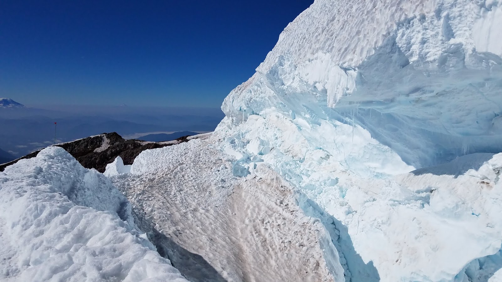
Crevasses and moats around Camp Schurman
The snow and ice around Camp Schurman continues break up at a steady rate but the general path out of camp and up onto the Emmons Flats remains the same. As fewer teams continue to attempt the route each week, the boot back has nearly disappeared. The latest reports are that the route still remains largely intact up high and continues to traverse all the way out to Liberty Saddle. As before, route finding issues and long summit times have continued be the largest obstacle for climbers.
Teams planning to climb this weekend can expect brisk conditions as fall is in the air and freezing levels are predicted to stay cool. Ice screws in addition to pickets are becoming a necessity for the route as firm snow and exposed ice present themselves. With the forecast calling for sunny skies and cool conditions up high, a weekend in the alpine at Camp Schurman surely won't disappoint. Crowds are looking minimal and rangers are happy to discuss the route/conditions further for those who decide to make the trek!


Wednesday, August 29, 2018

Disappointment Cleaver - 8/28/2018

The DC is holding on.  The number of independent climbers has dropped off considerably over the past couple of weeks.  The scene at Camp Muir is a stark contrast to the middle of July. The smoke has cleared out and there has been a brisk hint of Fall in the air over the past few days. There are also several large crevasses around Camp, so beware!

A large crevasse on the 'wind roll' near tents. 

The route itself is in late season condition and therefore a little more exciting than usual.  There are several ladder crossings and hollow bridges to contend with, along with increased rockfall exposure.  The guide services are still running successful trips and a handful of independent parties summited this week as well.

Approaching Ingraham Flats.  The Disappointment Cleaver is entirely melted out and the route ascends the 'spine' of the Cleaver to its top at 12,300'.

As rangers descended the route on 8/28, guides were putting in a ladder above Ingraham Flats. This should help cut out some extra distance on the route as it was previously going high to end-run this crevasse.

A new ladder near 'high crack'. 

Additionally, there are ladders at 12,700' and around 13,000'.  Both of these are actually several smaller ladders lashed together to span 10-15' wide crevasses.  These crevasses are over 100' deep.  The ladders have hand lines but are still a bit precarious.  If you are uncomfortable walking across these ladders then don't be afraid to turn around.  As with all 'fixed gear' it is important to assess their integrity.  Don't just blindly step onto them.  Make sure both ends are resting on either side and that all of the pickets are sound.  It is a good idea to clip one of the hand lines with a tether/locking carabiner attached to your harness for additional protection.  Falling off of one of these ladders without clipping in would entail a large fall and swing.  There are pickets on either side for 'running pro' and you should also clip your rope in as you go across.  Consider belaying your partners across these ladders if there's any doubt about falling!

The 12,700' ladder on the descent.  

The 12,700' ladder. 
The ladder at 13,000' - taken on the descent.  This ladder is not quite as long as the 12,700' ladder.  

A hollow section around 12,800' with a hand line.  
8/28 track log.
All in all it's a nice time to be on the mountain as we transition into Fall. Those looking for a more challenging DC climb will not be disappointed.  

Thursday, August 23, 2018

Stormy Season Changer

An upper level low pressure system passes through the region this weekend and with it might come the end of the freezing levels that soar above the mountain.  A 7500 foot freezing level predicted on Friday seems to be the coldest and a big change from 15,000 foot freezing earlier this week.  There's also quite a bit of wind generally associated with a flux in temperature this large.  It's not a great idea to be up on the upper mountain when there's high winds or a swirling cloud cap.  Here's a blurb from the latest Recreational Forecast:

.SYNOPSIS...Cooler weather on the way beginning Thursday. A weak 
upper level trough will move through the park Thursday night  
with the flow aloft becoming northwesterly. The combination of low
level onshore flow and northwesterly flow aloft will clear most 
of the smoke out of the area by Friday. Weak systems embedded in 
the northwesterly flow aloft will cross the area over the weekend 
for a slight chance of showers.
 
An example of clouds building near Mount Rainier from a couple years ago.
With the fall equinox still a month away it's hard to believe that autumnal weather has already arrived, but the sun has started to dip lower in the sky and the long term forecast has a cooling trend to it.  It's the time of year to start packing warmer clothes for a summit attempt and to be prepared for longer, more intense storms.  Also, be cautious on the now steep and firm late-August snow when it refreezes.  The slushy booting conditions of mid-summer can become dicey and treacherous before the new soft snow of winter falls. 

Here's a link to some of the more useful weather resources to help predict what conditions will be like when you're on the mountain.  Remember to check in with rangers when you register at the ranger station and the evening before you climb at high camps for the latest forecast. 

Emmons-Winthrop & Camp Schurman Update 8/23

Emmons-Winthrop Route from Camp Schurman. 
Over the course of the last month, fewer and fewer climbers have been showing up to Camp Schurman in order to attempt the Emmons-Winthrop Glacier Route. With late-season route finding challenges, broken glacial conditions, high temperatures, and intense smoke it's not hard to see why climbing numbers are on a downward trend. With that being said, there are still a number of teams trickling into camp and attempting to climb. For those parties well versed in glacial navigation, route finding and managing tricky crevasse hazards, success has come in the form of 14-17 hour summit climbs. Despite having previous experience, these teams reported challenging route finding in the dark, given the lack of bootpack and the haphazard nature of crevasses strewn about the mountain. Many teams that showed up to camp and felt unprepared to handle to challenges of the current route.  They decided to bag their climb and simply enjoy a night in the alpine.

Overall, the route is still following the same general track that was posted on 8/6/18. Climbers continue to report insecure cracks just out of camp, on the lower corridor, traversing back to the north around 12,500'-12,600', and again near the bergschrund at 13,400'. In addition to the upper mountain, it's worth noting that hazardous conditions can be found much lower as well. Glide cracks and overhung crevasses are beginning to open up along the edge of Camp Schurman.  Climbers should pay attention to where they are walking when collecting snow and pitching their tents.
View of the Inter Glacier

In addition, as the summer heat continues to take its toll, the Inter Glacier has melted out to a point that is quite hazardous due to increased rockfall, open crevasses and large expanses of exposed ice. Teams should pay extra attention to the hazard both overhead and underfoot. Once atop the Inter Glacier, the standard descent onto the Emmons from Camp Curtis is also causing issues for inexperienced teams. As the glacier and seasonal snowpack recede from the ridge, what's left behind is steep, crumbly terrain that is insecure underfoot and exposed to the moat below. Although one can see from the photo that the route still connects, teams should be prepared to handle this terrain, provide security through some form of belay or perhaps turn around all together. Once onto the Emmons, a long traverse will bring you up and around so that you actually drop down into Camp Schurman as opposed to climbing up into it. Doing so avoids the loose, crumbly and steep slope that climbers use earlier in the year to access camp.

Line showing the route onto the Emmons Glacier at about 9000 feet.

DC update from 8/22

Track of DC route on 8/22
In the last week the DC has stayed relatively the same with some minor changes. Of course, with the freezing level having been above the summit some of the days this week, all the crevasse bridges have only thinned. The objective hazards of rock fall, ice and serac fall, and crevasse falls are high this time of year.

Due to minor route alterations, the number of ladders change almost from day to day. Be sure to assess these before crossing them, especially on the descent, in case they have melted out.

The route goes slightly further up the Ingraham Glacier out of the flats before dropping down and traversing toward the cleaver itself, which is all loose rock.  Be especially careful at this point on the route.  The thin glacial rib used to access the cleaver is prone to rockfall from above, has steep firm icy footing itself, and a significant moat below.  At the top of the cleaver the route now veers slightly up and left before cutting right through the crevasse jumble formed by the glacier splitting around the cleaver. And the traverse up high toward the Nisqually Glacier has taken a slightly higher route.

All and all, this route takes a higher level of skill, more physical fitness, and larger acceptance of risk than it did in July and early-August.  Be sure to keep your head up and move efficiently through the numerous exposed spots, and always assess a bridge crossing before taking it.

Friday, August 17, 2018

Emmons-Winthrop Update: August 17, 2018

Emmons Glacier from Camp Schurman on 8.17.2018
Weeks of hot weather have resulted in challenging late-season conditions for the Emmons Glacier and the Inter Glacier approach. The Inter Glacier is melted down to skeletal glacier ice in wide swaths and sports many open crevasses; more notably, the approach gully to the Inter Glacier appears to have completely melted out, increasing the potential for rockfall on that approach. Descending from Camp Curtis onto the Emmons Glacier also presents serious rockfall danger.  Wear helmets, and scout your chosen line.

Glacier Basin
Looking down the Inter Glacier

Inter Glacier and Steamboat Prow

The Emmons Glacier itself has been climbed in the past week, however it is presenting somewhat typical late-season challenges and is increasingly circuitous. Overall, the route isn't very different than it was in recent posts--but with guided climbs done for the year--do not expect a bootpack or wanded path. Be prepared to find your own route, assess snow bridges and crevasse crossings (even in camp!), and be fully self-sufficient on your climb since it is likely that your group will be alone on the upper mountain. Expect a long summit day, potential for crevasse falls, firm snow and ice underfoot, and changing glacial features on the descent in these warm temperatures.

Crevasses above Camp Schurman as viewed from Steamboat Prow

DC Route Update: August 17th


Smoke layer across much of Washington. One of the few mornings the upper mountain was clear. 

As warmer than average summer temperatures continue to impact the upper mountain, situational awareness may be more important than you'd think. Although the peak season of climbers may be behind us, there is still plenty of activity going on up at Camp Muir and along the Disappointment Cleaver corridor. As of 8/16/2017 the DC route still remains largely the same, despite some subtle changes every few days.

Numerous ladder crossings, hand lines, hazardous rockfall and icefall zones, thinning snow bridges, and steep and firm glacial snow are what currently lay between Camp Muir and the summit. To some, these conditions may pose too high risk to justify a climb. For others, these conditions may seem manageable given a party's experience, rate of climb and technical ability. Wherever you may find yourself on that spectrum, rangers are asking that you truly assess and address the hazards that pose a threat throughout your climb. Again, situational awareness.

Ranger using a hand line across one of the more hollow sections of the route. 


Guide services have been working hard to keep the DC "going" through the constant re-routing. Something to bear in mind on your climb is the fact that sections of the route are melting out and falling out quickly. Simply because a ladder or a fixed line was secure and in-place upon your ascent in the middle of the night, doesn't guarantee it will still be in "acceptable" condition by late morning or mid afternoon on your descent. Pickets melt out, anchors weaken, ladders shift and rocks continue to fall when the weather is this hot. Parties should plan to "beat the heat" with early turn around times, and they should assess anchors, lines and ladders for themselves rather than assuming they are still secure. 

Over the last few weeks, rangers have seen an increased number of climbers attempting the route without the proper equipment. Here's some things to ensure each member of your party has:
  • Helmet
  • Harness
  • Crampons
  • Ice Axe
  • Sunglasses
  • (1 or 2) Picket(s) or another form of snow anchor
  • (1 or 2) Ice Screw(s)- it's that time of year
  • Crevasse rescue equipment- pullies, prussiks, cord
  • GPS- and knowledge to use it!
One of the many sections of the route exposed to fairly intense rockfall. 
All in all, there are many factors that must be taken into account when considering a late season summit attempt via the DC. It's up to individuals and their teams to accurately assess their own abilities, their level of preparedness, the weather, the conditions, and the unavoidable hazards that exist. By paying attention to your "situation" you'll be best able to mitigate risk, avoid certain hazards and minimize the danger of a late season summit climb. 

Friday, August 10, 2018

Updates before the Weekend!

The busiest time of year has now passed on the mountain and things have started to settle down.  Guide services have finished up with their trips on the Emmons-Winthrop Route and many independents have shifted over to climbing the Kautz Glacier and Disappointment Cleaver Routes.  Here's some updates for conditions on these routes:
Also, here's a write-up on navigating around Mount Rainier.  There's definitely a 'science' behind finding your way back off the mountain in a storm, but there's a key piece that's all 'art' - which is at the heart of climbing up and down mountains in general.

Have a great weekend!

Disappointment Cleaver update -- 8/9

Warm temperatures and late season conditions have combined to create increasingly difficult conditions on the Disappointment Cleaver route. Weeks of above average temperatures have thinned snow bridges and widened crevasse crossings, making the route more circuitous and prone to change. Overall, however, the route remains in similar conditions from recent blog posts.

Many of the technically challenging sections of the route are becoming more hazardous. Getting onto Disappointment Cleaver above Ingraham Flats (11,200') is a serious endeavor. Rockfall has been prevalent at all hours of the day and night; this hazard is best mitigated by limiting your exposure to it. The glacier-to-rock transition area is also steep, icy, and crevassed, making the timing and location of the rope transition a challenge. Shortening the rope too early exposes the group to additional crevasse fall hazard, while adjusting it too late increases overhead rockfall hazard by stopping in the danger zone. All of this requires competent ropework and speedy transitions to reduce the time spent below loose rock. Unfortunately, these transitions require practice and it takes a keen eye to anticipate the best place to do it.  There is no simple answer when it comes to managing the co-mingled hazards in this zone.

Many groups have been surprised by the amount of time required to climb and return to Muir and have decided to spend an extra night at Muir after their climb. Planning for a three-day climb at this time of year might help set you up for success and not overdue.


Thursday, August 09, 2018

Navigating Mount Rainier

So how do the climbing rangers navigate the intimidating glaciated peak of Mount Rainier on a daily basis? Mountain navigation is a complex skillset that is developed over years of practice and training, but a few key concepts and tools might aid you in your next adventure.
Digital navigation has its perks.

First and foremost, keen observational skills are mandatory. Being aware of your surroundings, looking for and identifying features ("oooh, that's Cathedral Gap!"), and recognizing hazardous terrain is the most critical skill to develop. Identifying these on a map and orienting yourself to the landscape helps ingrain these details and make future decision-making easier. Using an altimeter and paper map may not be as fashionable these days, but it is less reliant on batteries; it is still a requisite skill for mountain goers.

For digital reassurance of our navigation decisions, many of us use mapping apps on smartphones like Gaia, Avenza, Trailmap, and TopoMaps+, rather than carrying a GPS during the summer months. These apps are relatively cheap (especially compared to other stand-alone GPS devices), and you can pre-download maps onto your phone before your trip. Once in the mountains, it is easy to track and insert waypoints while conserving battery in airplane mode. We always have at least one phone tracking our route during the climb. Certain apps allow you to easily share waypoints and tracklogs as well.

That being said, there are many other GPS apps and stand-alone GPS devices that work well.  Be aware that certain tracking settings can eat through battery power relatively quickly, especially if you have an older phone or if you are using it in the cold (which is likely).  It's a good idea to have backup batteries, a rechargeable battery pack, or a backup device.

The other bonus for using a phone is--in the event of an accident--your phone may be able to connect to 911 from the upper mountain (all cell towers are required to pick up the call regardless of your cellphone carrier). Conserving battery life for the phone's primary purpose is a recommended strategy. Many parties choose to have one person track their team's climb on one phone while conserving battery life on everyone else's phones.

Keep in mind that you're probably only going to "need" your GPS in a storm, which can happen any time of year. A protective case and waterproofing should be considered mandatory.  Practice using your GPS with gloves on.  Also, can you use it when there's water on the screen?  These are things to know and learn before a entering into a stressful situation like being on a steep glacier near crevasses in a white-out. It is important to remember that no GPS or phone app is a predictor of crevasse locations and that, even with a digital track to follow, navigating glaciers in whiteout conditions is frequently terrifying.

If you choose to use wands (as well as a GPS) to mark your route on the ascent, please be sure to remove them on the way down and carry them out. Routes change rapidly and wands suddenly become just litter on the mountain when routes are not maintained.

Kautz Glacier 8/8/2018

Approach to Kautz from Alta Vista taken on 8/6/19
Sustained, above average temperatures have been causing glaciers and snowfields to melt out and change rapidly everywhere on the mountain. As chossy rock melts out from the snow and ice, things become even more prone to moving. As you can see from above, crossing the Nisqually and Wilson Glaciers expose you for a long period of time to rock and ice fall. On top of that, traveling through that type of terrain is slow.

If you are looking to climb the Kautz in the next month, a route with less objective danger enters from the Comet Falls trailhead. This will minimize your exposure time to rockfall and overall time in hazardous terrain. Not to mention, the wildflowers on Van Trump should be glorious now. Take a moment to stop and enjoy the flowers on your hike up.

That being said, even with an approach via Comet Falls, the Kautz Glacier still presents lots of hazards and risks to assess and manage. A large, natural rockfall occurred last week above the rock-step where the route descends from the bivy sites to the Kautz Glacier. Falling boulders swept through the area at the bottom of the step, crossing an area that had commonly been regarded as a safe location. Scouting this area in the evening before your climb will help you decide how to move though the area faster and reduce your risk. The glacier travel above the ice pitches remains viable, but is becoming more circuitous and time-consuming. Warm temperatures may make these upper mountain crevasse crossings more dubious as time progresses.

Set yourself up for success and plan a head to move quickly through such areas to minimize your exposure time. Keep your head on a swivel and your wits about you.

Emmons Update 8/6/18

The Emmons Glacier route was continuing to be climbed through the weekend of 8/6/18. The route from Camp Schurman to the summit was in similar condition to the last blog post. A major junction at 13,300 feet (below the bergschrund) trends right and out to the Winthrop Saddle before climbing up the last 800 feet to the summit. Don't be suckered into climbing directly over the bergshrund by the old bootpack -- the bridge is thin, wide, and incredibly consequential if it fails. Walk the long way to Winthrop Saddle!


Current Track of the Emmons Route. 8/6/2018

Conditions directly above Camp Schurman and up to around 11,200' seem to be some of most hazardous on the route. Not much snow exists above the glacial ice in many locations and this leads to "punchy" conditions as you are forced to navigate through a sea of holes. Rangers observed and responded to a visitor crevasse fall between Camp Schurman and Emmons Flats as a team was working their way through this section. The route that you take in the cold morning hours may not be the way you want to return. Use caution and attempt stay on the grey glacial ice where possible.

Crevasse maze above Camp Schurman. Camp is in the lower left.


The upper mountain above, 12000 feet, is continuing to hold together. Many of the large crevasses require end-running and the passable crevasse bridges are becoming hollow. Rangers found that the majority of cracks had more than one possible crossing. Assess your options for the most solid crossing--it may not be where the major boot pack takes you.
Climbers descending from the Winthrop Saddle back to the 13300' route junction.

Climbers returning to camp as a thunderstorm approaches.
       
Inter Glacier:
The approach to Camp Schurman on the Inter Glacier is continuing to become more and more crevassed. As warm weather continues and bridges continue to thin, traveling as a roped team is recommended on the Inter Glacier.

Glissading is strongly discouraged due to icy and crevassed conditions.
View of the upper Inter Glacier from Mount Ruth. Climbers path proceeds up the center.

Sunday, August 05, 2018

DC Route Update 8/1

The DC route is largely the same route with many of the same hazards as in the previous post, but with a few small changes. Once to the top of the Cleaver, the route continues climbing uphill for around 300 feet to a large serac jumble (referred to as the popcorn). Where the recent route climbed beneath this feature, the current route travels up and over this formation--which reduced the objective hazard, but by no means resolves the issue and hazards. From this point,  continue climbing towards the Emmons Shoulder, traversing along an exposed fin with a very large crevasse just uphill until faced with a steep side-hill slope that will bring you back to the old route.

Be aware that with the elevated freezing levels and all the warm weather, the upper mountain has been changing very quickly. Serac movement can change the route quickly which may result in the route becomming impassable. As stated in previous blog posts, be ready for things to change rapidly and have a reserve of energy to overcome potential challenges if you happen to come across an route-finding or navigation issue while descending.

For a more detailed description on the entire route, see the previous Blog Post  

A view looking up from the top of the Cleaver

Climbing around the top of the serac feature above the Cleaver

Looking towards the Emmons Shoulder. The Ranger is about to climb onto the fin.

Climbing out onto the Emmons Shoulder with a handline

The route is not without serac hazard.