Showing posts with label Kautz Glacier. Show all posts

Tuesday, June 03, 2025

Kautz Glacier 06/01/2025

The weather over the last week has brought mostly sunny days, moderate temperatures for this time of year with freeze levels bouncing between 9-11k, and consistent north winds providing for generally pleasant climbing conditions. Still, a few brief systems have rolled through as reminders to stay prepared for wintry weather and whiteout navigation, though little new snow has accumulated. Long days and warm weather as we head into summer continue melt and change surface conditions daily.

From Panorama Point looking across the Nisqually and Wilson Glaciers at the aproach to the Kautz.


As of 6/01/2025 the approach to the Kautz from Paradise is still predominantly snow, starting at the parking lot. Crossing the lower Nisqually glacier and gaining the Wilson bench is straightforward currently and climbers' have options as to how they would like to reach the Turtle snowfield. There have been few days with freeze level below 9K recently and snow conditions are changing rapidly at low elevations. Be wary of soft and sagging snow bridges over crevasses, as well as overhead cornice and rockfall potential. As a reminder, the lower Nisqually and Wilson are glaciated terrain and traveling roped up is always recommended. 

The Turtle snowfield and camp Hazard looking up from the Castle at 9k'


From the Castle up the ridgeline along the Turtle to the rock step, multiple camp sites/tent pads are starting to melt out and running water is occasionally found in the rocks, but water maybe unavailable if the freezing level is low. The rock step is melted out with 15' of traversing downclimb to reach snow. There was a handline in place on 6/01/25, however never trust your life to fixed gear without inspecting the anchor and rope quality first and be prepared to manage this feature on your own. Traversing from the rock step into the main Kautz chute is moderate snow currently, however the traverse moves under seracs that require attention. 

The rock step looking forward

The rock step looking back, 10-15' of traversing-down climbing to a snow ledge.


The Kautz chute is currently steep snow through the first pinch, ~50 degrees, but a few more warm days may melt this down to glacier ice. The second and final step of the chute was one pitch of AI2 and steep snow. A light rack of pickets, several ice screws, and two axes were useful for this pitch. Above the chute the route continues into low angle glacier walking towards the Wapowety Cleaver. There are several large cracks in this 12-13k' zone that are bridged currently allowing for direct travel but may require long end runs as they melt out. 

The Kautz chute from the rock step. The lower pinch is still snow while the upper requires a pitch of AI2 climbing.   


Steep snow leading into the ice pitch of the upper chute.

Above the Wapowety cleaver, climber's currently have the option to head climber's left towards Point Success through the steep snow of the upper Kautz, or climber's right onto the upper Nisqually glacier and towards the Columbia Crest through lower angle terrain. Moving off the Wapowety Cleaver onto the Nisqually may increase in difficulty as the moat along the cleaver melts and widens. 

Low angle glacier travel of the upper Kautz below the Wapowety Cleaver.


Monday, July 29, 2024

Kautz Glacier Conditions Report 7/27/24


July 28th, 2024


This blog is maintained by the Mount Rainier National Park Climbing Ranger team for use by recreational non-guided climbers. Use these reports as a baseline, but plan for changing conditions.


In recent weeks Mt Rainier has had overcast skies and slightly lower than average temperatures followed by clear skies and near normal temperatures. Snow levels are at about 7,600 feet and the wildflowers are in full effect in the subalpine meadows. There have been a few fires to the east and to the north, yet the air quality and upper mountain views have remained relatively clear. The main hazards that climbers should consider include:

+Ice fall under seracs and rock fall

+Crevasse fall due to thin snow bridges

+Dehydration

Kautz Glacier Route


The approach to the Kautz Glacier route via Commet Falls trailhead is free of snow up to the Turtle Snowfield at about 7,000 feet. At this time hikers will see numerous wildflowers including lupine, paintbrush, avalanche lilies and pasqueflowers. Please avoid the temptation to pick the flowers and only take photos. The approach via the Lower Nisqually to the Wilson Bench is heavily crevassed but passable at this time.


Approach track via Commet Falls Trailhead


Campsites at both upper and lower Castle Camp (9,200 feet and 9,400 feet) are snow free with running water near by. The upper bivies between 10,800 and 11,200 feet are also snow free. Please make use of existing tent platforms and avoid creating new sites when possible.

 
An example of a Kautz Route track


The rock step at the start of the Kautz climb is still currently filled in making for a small move down onto the snow. There is an existing anchor and fixed rope here. Be sure to inspect for yourself if choosing to use this for security. The ice chute has one mandatory ice step at the very base. This portion is about 50 feet long. Options for additional pitches of ice exist to the climbers right of the steeped snow in the center of the chute. The remaining snow is heavily sun affected and has formed into buckets and steps.

 
Lower ice chute displaying the ice step


Once past the ice chute, navigating both the upper Kautz Glacier and the Upper Nisqually involve crossing a series of snow bridges and moving over penitentes. These are snow “spikes” which form at high altitudes and are the result of radiation and sublimation of the snow. Consider adjusting your estimated travel times as these features reduce the speed of travel somewhat.

 
Wapowety Cleaver looking across the upper Nisqually


For specifics on the Kautz Glacier route please reference the NPS route briefing packet- Kautz Glacier Guide. Climer registration can be done at either the Longmire Wilderness Information Center or the Paradise Wilderness Information Center. Both are open from 7:30 am- 5:00pm daily. “Blue bags,” or human waste bags, can be found here. Please carry all waste off the mountain. Be sure to check out at after finishing your climb. Lastly remember to pay for an annual climbing cost recovery fee.


Thursday, June 27, 2024

Ski-Mo or Ski-No?


June 27th 2024

This blog is maintained by the MRNP Climbing Ranger team for use by recreational non-guided climbers.

Use these reports as a baseline, but plan for changing conditions.

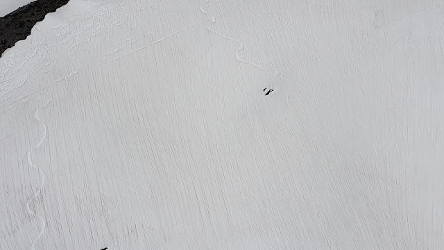
Ski tracks on the Paradise Glacier showing near misses with crevasses - NPS Photo


Skier traffic on the upper mountain has been hitting all-time highs this spring as the skiing itself rapidly deteriorates in quality. Solar input, especially as we approach summer, can lead to conditions such as: thin and discontinuous snow that requires steep down climbing; variable snow surfaces such as sastrugi, sun cups, runnels, and penitentes; open crevasses; weak snow bridges; and rockfall. Ski movement ability is the best way to improve your safety margin from falling while skiing in the mountains. When combined, the conditions described will make a route "out of condition" even for the best of skier. The routes have been changing rapidly due to consistent high freezing temperatures and sunny days.

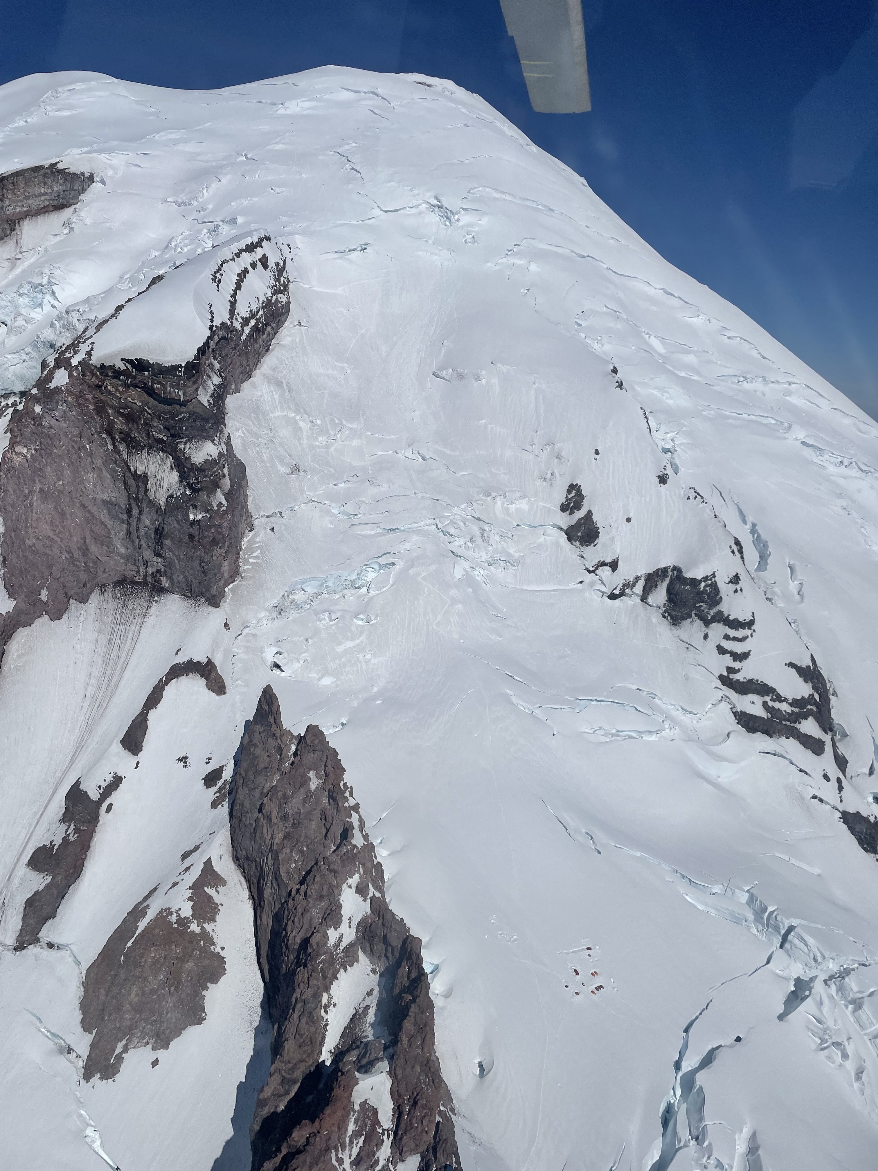
An unseen crevasse causes a skier to fall and lose control - their tumbling impacts can be seen below the crevasse - NPS Photo

Even if someone skied the route a week prior, remember that we are in a highly dynamic environment that is changing at a fast rate. This results in quick route changes and new crevasses opening in a matter of hours, let alone days. Not only must you possess the skills necessary to navigate through heavily crevassed terrain, but anyone skiing the mountain must possess expert skiing abilities as any unplanned fall could have severe consequences.


Rangers are observing a marked increase in skier traffic on the upper mountain in recent years, with a decrease in the movement abilities of skiers and riders. This has coincided with an increase in accidents involving skiing. One constant observation that rangers are making is that the basic approach to risk management is often skewed in skiing parties.


The two biggest misconceptions about the risks involved with skiing on Rainier are:

 
  • Speed of Glacial Navigation on a Ski Descent: Since you may have more days on skis annually going downhill at a resort than you do walking downhill with crampons on, you may be under the impression that skiing down the upper mountain will be easier than walking. What this perception lacks to factor in is that when you are skiing, the same glacial navigation and snow bridge evaluation you had to perform on the way up the mountain has to happen at over double the speed on the way down! Rangers have seen many close calls with skiers approaching blind, convex rolls at speed -- just barely stopping before skiing straight into a crevasse. In one case, a skier was observed accidentally jumping a crevasse they did not identify. When managing open glaciers, slow is smooth and smooth is fast. So be sure to ski slow and in control, especially when you cannot see the whole line you are skiing.


  • Safety of Skis vs. Booting Uphill: It is often assumed that since skis spread one's weight out over a large surface area, they are a safer method of travel on glaciers. This may be true for flat valley glaciers, but while ascending on steep terrain, the opposite is often true. The extra weight and awkwardness of skiing or snowboarding makes the endeavor more challenging and requires more attention paid to risk management. Variable, steep surfaces with significant fall consequences are not the place to practice “high-stakes skinning”, especially if you are new to backcountry travel.  


Individuals considering a ski attempt on Mt. Rainier should possess significant previous experience skiing on glaciers and at altitude. While no other Cascade volcano possesses the same degree of challenge for a ski mountaineer, it is strongly recommended to have experience skiing on other peaks like Mount Baker and Mount Adams before coming to Mount Rainier. Mt. Rainier has more substantial objective hazards and complex glaciated terrain than any other mountain in the lower 48. Combine this with the unpredictability of how high altitude will affect you, and having significant previous experience to draw on will provide a much higher safety margin on any ski descent of Mt. Rainier. A deep well of experience managing these hazards on less complex terrain should be developed before heading to Washington State's highest peak.


Other Safety considerations for planning a ski trip on Mount Rainier:


Team Selection

This is the most important factor to consider when planning a trip to Mount Rainier. The vast majority of terrain on Mount Rainier can be classified as “no fall” territory. Although ski falls may be common and insignificant in a ski resort, all falls on the upper mountain are serious. Simply losing an edge can easily cascade into an unstoppable slide into an open crevasse. Reverting to side-slipping or falling-leaf technique, rather than linked turns, can help maintain control of your ski descent. If anyone in your party has any doubt of their ability to safely ski the route, you must be willing to communicate that and revert to appropriate roped glacier travel techniques - this would include stashing skis low and continuing on foot. If you doubt your ski ability, consider hiring a professional to give you objective feedback in a more controlled environment such as a ski resort or less complex ski mountaineering objective.


Successfully completing a ski descent of Mount Rainier requires individuals and teams who are competent in a broad array of mountain skills. Mountaineering, glacier travel, rope techniques, navigation, and expert-level downhill skiing skills with a heavy backpack are the bare minimum.


Route Selection

There is no easy way to ski from the summit of Mount Rainier. All routes feature complex glacier travel, steep skiing, and long sections of no-fall terrain. Commonly attempted routes include: Emmons-Winthrop, Fuhrer Finger, Kautz Glacier, Success Couloir, and Ingraham Direct. There are many excellent ski descents on the mountain that minimize exposure to crevasses, ice and rock fall, and high altitude. Descents of the Muir Snowfield, Van Trump Snowfields, The Turtle, and Inter Glacier all serve as a nice introduction to the challenges of skiing on Mount Rainier.


Skiing down a route that you didn't climb up is generally not recommended. When walking up the route you plan to ski, it allows you to see and assess hazards, record a GPS track, and plan your descent. When onsighting a descent, especially on skis, you are suddenly put in the position of quickly identifying hazards and route finding as you go in a broad and expansive glaciated landscape.


One Day vs. Overnight Trips

An increasing number of teams opt for single day attempts; these require exceptional fitness levels. We see many teams that begin their attempt together but slowly get spread out across the upper mountain. This is unacceptable. It is crucial that team members remain within verbal and visual communication at all times. If one party member needs to stop or descend, the group should do the same. Do not leave anyone alone on the mountain. Consider a multi-day attempt so that you can begin your summit attempt rested and focused for the strenuous day ahead. Overnight trips also present better opportunities to time your descent for optimal conditions.

No matter which strategy your party chooses you must register for your climb and pay the climbing fee. More information on that process can be found here.


Weather and Avalanche

When signs of current or developing snow instability are present, the best course of action is to descend immediately from your current location rather than trying to outsmart the avalanche problem. It only takes a small amount of moving snow to knock you off your feet and push you into places that have serious consequences.


Snow Surface Conditions

This is probably the hardest variable to predict when planning a ski descent of Rainier. Snow conditions vary widely across aspect and elevation. The upper mountain rarely features smooth snow surfaces that could be defined as “good” skiing – it is commonly “survival skiing” up high. The surface above high camps is frequently a mix of breakable wind crust, very firm wind packed snow, ice chunks, sastrugi, firm and smooth (slide for life) conditions, and refrozen snow. Expect to ski “bad snow” for some, or all, of every descent on this mountain.  


Furthermore, it is rare that a ski descent does not require some down climbing. In many cases the decision to transition to crampons and ice axe for a short down climb can be a life-saving event. You must expect that you will need to take off your skis, rope up and climb down intermittently using proper mountaineering techniques.


Glacier Conditions

As the season progresses, all potential ski descents become more challenging as crevasses open and more ice is exposed. The trend in recent years has been to attempt ski descents earlier in the season to help mitigate these hazards, though this brings increased risk of avalanches, challenging navigation, and more hidden crevasses. Regardless of when a descent is attempted, always ensure that you can see to the bottom of the slope you are on. Convex rolls are classic trigger points for avalanche's and often hide crevasses on their downhill side.


All parties on foot should be roped up to help protect against glacier hazards. This means that transitioning from skiing to booting (or booting to skiing) should be done after roping up and spreading out the team. The greatly reduced surface area of boots compared to skis greatly increases the likelihood of punching through a snow bridge into a crevasse.


Technical Rescue & Rope Considerations

All parties must be competent in crevasse rescue. Every member should wear a climbing harness at all times in the event of a crevasse fall. Carrying two ropes affords a greater safety margin in the event that the person carrying the only rope falls into a crevasse – this risk can be easily mitigated. Many teams opt to bring a single 60m rope, however carrying two ropes per team that are each 30+ meters increases rescue safety margins while having a commonly missed benefit: the ski quality for the party as a whole is increased as no one is skiing with the weight of a 60m of rope in their pack! Each party member should have enough supplies to construct a rescue anchor, rappel into and ascend out of a crevasse, and execute a haul system. All other mountaineering equipment should also be carried, including crampons, ice axe, helmet, navigation, and survival gear.


A ski descent of Rainier can be one of the most rewarding experiences for a competent party but it can quickly turn disastrous for the unskilled or unprepared. The fact that descending on skis is so much faster than on foot allows skiers to get off route and into problematic terrain all that more quickly. Proper planning and a high degree of caution is a prerequisite for a successful ski descent of the mountain.

Friday, July 15, 2022

South Side Aerial Photos. It's looking good!

Coverage is looking good on the Mount Rainier. Climbing routes and some ski descents seem to still be in great shape! 


The Kautz glacier, the Turtle, the Wilson glacier/Furher Finger, and the Nisqually.


The Kautz glacier, the Turtle, the Wilson glacier/Furher Finger, and the Nisqually.


A view of the upper and lower Kautz glacier and the Van Trump zone.

Wednesday, July 06, 2022

7/6 South Side Aerial Photos

Below are aerial photos from the south side of Mt. Rainier over the weekend.  These may be helpful for broad trip and route planning purposes.

Looking up the broad and well defined ridge of Success Cleaver


Kautz Glacier

Fuhrer Finger (the couloir with ski tracks) & Fuhrer Thumb 

Ingraham Direct. Photo taken above Cathedral Rocks. 
Note Ingraham Flats tents for reference

Thursday, June 23, 2022

Kautz Conditions 6/22

Kautz Conditions appear to be inline with other routes on the south aspects of Mount Rainier- for the most part, routes such as the Kautz, Fuhrer Finger & Wilson Headwall all appear to be well filled in. Snow still blankets most of the steeper pitches, such as the "ice tongue" and appears planar and well connected. The rock step at Camp Hazard has a minimal drop to access the base of the ice tongue of the Kautz and should be relatively easy to navigate in both directions of travel. The Turtle snowfield is well filled in and is beginning to corn by mid morning, although climbers may encounter post-holing if they are ascending later in the day. 

The lower crossing of the Nisqually is also well filled in and minimal crevasses are visible. This being said, temperatures are forecasted to remain warm and sunny. Use caution when navigating a crossing as crevasse bridges may soften, leading for higher potential for a crevasse fall. 

Lots of older, but surprisingly large wet-loose avalanche debris exists from prior shed cycles and activity should act as reminders for climbers and skiers alike to heed warning about the possibility for avalanches. We are just cresting into our first real warmup of the season. We have received lots of snow this spring- that mixed with more warm and sunny weather presents the potential for more Wet snow related avalanches in the upcoming weeks.

 
A view of the mountain from the Lower Nisqually
crossing below Glacier Vista.
A view of the Kautz Glacier from the rock step at Camp Hazard

Friday, May 20, 2022

Good Weather for the Weekend But Please Use Restraint

It looks like winter's icy grip is about to loosen for the weekend and that is cause for some celebration, but we're asking climbers and skiers to use some restraint before rushing to the mountain this weekend. Caution is advised due to the combination of two heightened risk factors:

1) A human-factor of Scarcity due to a lack of recent opportunities to recreate can create a self imposed pressure to finally take advantage of a nice weekend. And, the unusually cold and snowy spring we've been experiencing has thwarted many plans so it may be tempting to rush to take advantage of this weather window. Social media can also contribute to the fervor and increase the pressure you put on yourself to take on a big objective.  Stay true to your ability level and maximize your enjoyment! 

2) A Rapid Warming on a snowpack that is currently in a mid-winter condition. The climbing rangers have observed a widespread natural avalanche cycle with avalanches of up to size 3 (large enough to destroy cars and small buildings) within the past four days. This cycle will likely continue as the temperatures and solar input increases.  Guides have also been reporting sudden reactions on wind slabs above 10,000 feet.  There's no avalanche forecast for the upper mountain.  Use your judgement (of knowledge of your lack of experience to make a good judgement) to know when to turn around. 

During the past few good weather windows we have had several human triggered avalanches in the Nisqually Chutes and one prolonged rescue high on the Kautz Glacier. All of these incidents were a direct result of groups trying to 'squeeze-in' their objective during a break in the weather and could have been avoided by taking a tactical pause and assessing conditions objectively. 

So that's what we're asking the climbing and skiing community to do, collectively. Slow down, take a breath, talk to your partners and communicate with each other about the risk you are taking.  There's an above average and seemingly deep snowpack, and we should be climbing and skiing in great conditions well into the summer.   We want folks to enjoy, but be able to return to the mountain!

NPS/Waterfall Photo

Sunday, May 15, 2022

April Showers.. and May Storms!

It's been an unprecedented stormy start to the summer on Mount Rainier.  Prepare for full winter conditions for any adventure in the park this May.  Not much to report conditions-wise since weather has been shutting most of the climbing and skiing down.  Use caution when entering onto steeper slopes on the upper mountain - the snow pack hasn't transitioned to a regular spring diurnal pattern yet, and there could be hazardous conditions with all of the new snow.  

The Paradise Wilderness Information Center (PWIC) is already open on weekends - come on up and register in-person!  Self-registration is still in effect during the weekdays until May 27th.  After May 27th the PWIC will be open everyday through the end of the climbing season in September.  Paying the Climbing Fee and obtaining a Climbing Permit is required for all climbers and skiers who journey above 10,000 feet or onto a glacier - even folks doing a single-push style ascent.

Rangers were able to get up in the helicopter for some aviation training and snapped some photos of the upper mountain.  See below for some photos taken May 10th and 11th.  We're excited for more stable weather patterns and a bit more sunshine - and excited to see everyone up on the mountain soon! 


Friday, August 27, 2021

Kautz Ice Chute Patrol


Ranger on rappel from the Kautz Ice Chute


The Kautz ice chute is in nice form for some late season tool swinging. Rangers from the park went on a patrol on 8/23/2021, detailed below is an account of what they found along their route. 

Approach Via Comet Falls and Van Trump Park 

Comet Falls trailhead is an alternative start to climbing one of the more popular climbing routes to the top of Mt. Rainier, the Kautz Glacier. For our patrol, the Paradise approach seemed more hazardous in the late season conditions and we opted for the Van Trump Park approach option.

While longer and more elevation to surmount via this approach, there are certainly pros to the Comet Falls trail start. First, you will notice the waterfalls cascading along the trail for the first 1.6 miles to the Comet Falls viewpoint. If you have not seen Comet Falls before, you are in for a treat. Second, above the Comet Falls viewpoint your level of solitude is sure to increase. The occasional day hiker will press on from the falls to Van Trump park, but on this patrol they were few and far between. 

Rangers descending toward Van Trump Park

Snowfields and Scree 

Above Van Trump Park (5,500') the unmaintained trail ascends a defined ridge trail before giving way to the scree and talus above. The trail trends N by NE and around 7,000' you begin to move between sections of rock and snow up to approximately 7,800'. From here a consistent bit of snow travel along the upper Van Trump Glacier will put you into the 9,400' elevation zone. Trending East across the rock band below the Turtle from here allowed our team to find running water and camping options numerous enough to set up camp out of the wind.


Sunset from near the Lower Castle camp around 9,400'

The Castle Area

The castle area, lower and upper, from approximately 9,250'-9,500' are common areas for teams to make camp. In the afternoon we arrived, there seemed to be an abundance of running water in this zone, and many options for camping. As the sun sets expect the water sources to reduce in flow significantly. 

The Turtle 

The two approach trails to the Kautz merge at 9,800' at the base of The Turtle. The slope of the lower turtle is approximately 45 degrees and in early season this feature can be efficiently navigated traveling on snow. We found the turtle had melted down to glacial ice, which increased the risk and slowed our travel. The icy conditions and exposure to ice and rockfall could be mitigated by staying along the western side of the terrain where the angle was slightly less steep, and the exposure to rock and ice fall was reduced. Climbing this features covers the elevation from 9,800' - 10,800' where a trail through the loose rock of the Wapowety Cleaver leads the climber to more camping options just below Camp Hazard and next to the rock step or rappel that must be descended to get into the ice chute at around 11,300'.


Looking at the upper portion from the lower section of the ice chute.

Kautz Ice Chute

To get to the ice climbing there is a rock step which must be descended. Rangers found there to be doubled, fixed static climbing ropes anchored at the step. Knots tied along the ropes would not allow the climber to rappel these ropes, but when utilized as master points to clip into with a personal anchor or a tether coming off the harness, they were helpful. At the base of the step a loose rock trail, above exposed terrain must be traversed to get onto the glacier where you traverse yet further under an area of ice fall potential with small crevasses that need to be negotiated. Moving beyond this hazard zone puts one into the ice chute and teams can pick out their line of attack from there. On 8/23 rangers found the ice pitches to be approximately two 400-450' sections, a lower and an upper section, separated by a patch of lower angle snow between the sections. The lower section was at approximately 50 degrees and the upper portion 70 degrees. Good, Fun ice climbing ensued!

For a more detailed look at the route, check out the Kautz Glacier Routebrief.


Sunday, June 20, 2021

Aerial Photos

Here's some recent (June 22nd, 2021) aerial photos from the south side of the mountain.  The mountain had a slight refresh with the June-uary storm cycles earlier this month, but the recent heat has been melting the new snow almost as fast as it fell.  Most routes are still hanging in there, but as the snow recedes, many of the routes begin to have an unsafe amount of rockfall and "close" for the summer.  Definitely remember your extra dark sunglasses this time of year!  

View of the upper Emmons Glacier - the "corridor" visible on the right side of the image.

Cathedral Rocks run in the center of this image, the Disappointment Cleaver is the rock ridge in the upper right of the image - note it's still at least 50% snow covered.

The Fuhrer Finger is the wavy-hourglass feature in the middle of the image, just to the left of the Nisqually Ice Fall.  Note the dirty, rock strewn section which has started to grow as the route melts out.

The Kautz Glacier's ice pitches are front and center in this image.  Not too melted out yet!

Wednesday, June 16, 2021

Camp Muir and Camp Schurman update 6/14

Winthrop glacier from Camp Schurman

High camps were lonely this past weekend- and for good reason. An atmospheric river event slammed Mt. Rainier and Western Washington with an impressive moisture plume.

Radar image from Sunday night 6/13/21

Precipitation in the park is measured at Paradise, where the weather station recorded 2 inches of rain since Friday!

The freezing levels hovered between 9,000 and 11,000 feet during this storm. Winds were intense at both camps making travel on the upper mountain nearly impossible. Camp Muir felt the full force of this storm, being exposed to southerly flow. Sustained winds at Camp Muir exceeded 50 mph all day Sunday, and gusts up to 99 mph were recorded.

Check out the Northwest Avalanche Center website for real time weather data from the stations at Paradise and Camp Muir.

Camp Schruman after the storm broke Monday evening.

Looking forward, conditions will warm and dry by mid-week. This weekend will see temperatures rise and freezing levels climb above 13,000 feet. That's good news, certainly, but how will that affect climbing conditions?

All the precipitation from the recent storm fell as snow above 11,000 feet, or the level of Ingraham Flats. That means the upper mountain could have feet of wet, heavy new snow. Strong winds likely transported this new snow across the upper mountain and created fresh wind slabs that could be triggered by a climbing party. Teams attempting to climb this week must bring avalanche rescue gear- including a beacon, shovel, and probe for each climber.

Rising temperatures and the powerful June sun will slowly stabilize these avalanche hazards as we approach the weekend. However, dangerous avalanche conditions could linger near the summit into this weekend. Continually evaluate the snow conditions while climbing this week. A large drift of dry snow that sounds hollow or cracks when you walk through it should give you pause; and may be a reason to turn around.

Shooting cracks in a wind slab

For the most up to date weather information, check out the Mt. Rainier Recreational Forecast

The climbing routes up the Disappointment Cleaver and Emmons/ Winthrop have not changed much in the last week. Check out the links above for more detailed information.

Climb safely, and enjoy the sunshine this week!

Wednesday, June 02, 2021

DC Route Conditions and Aerial Photos 6/2/2021

The Disappointment Cleaver and the upper Ingraham and Emmons Glaciers

A series of storms and lingering avalanche danger had shut the DC down to all guided and independent parties for eight days. After three days of calm and sunny weather however the guides re-established the route and the DC has been climbed every day since 5/31.

The route currently ascends the 'spine' of the Disappointment Cleaver and from there weaves it's way through the heavily crevassed upper Ingraham and Emmons glaciers.

Temperatures have warmed rapidly and with warming temps comes an increase in rockfall and crevasse fall danger. As we switch to summer climbing conditions please keep in mind the specific hazards that come with the changing season.

That said, climbing conditions are reported to be excellent now, so pick a good weather window and enjoy the mountain.

The rangers have been busy flying equipment to the high camps and removing human waste. We were lucky to get some great photos from the SW, East and NW aspects on the mountain. Here is a selection of them:

Wapowety Cleaver and the Kautz Glacier

Fuhrer's Finger

The upper Kautz and Nisqually Glaciers

The upper Nisqually, Ingraham and Emmons Glaciers.


The upper Emmons and Winthrop Glaciers


Curtis Ridge, the Willis Wall and Liberty Ridge