Sunday, August 05, 2018

DC Route Update 8/1

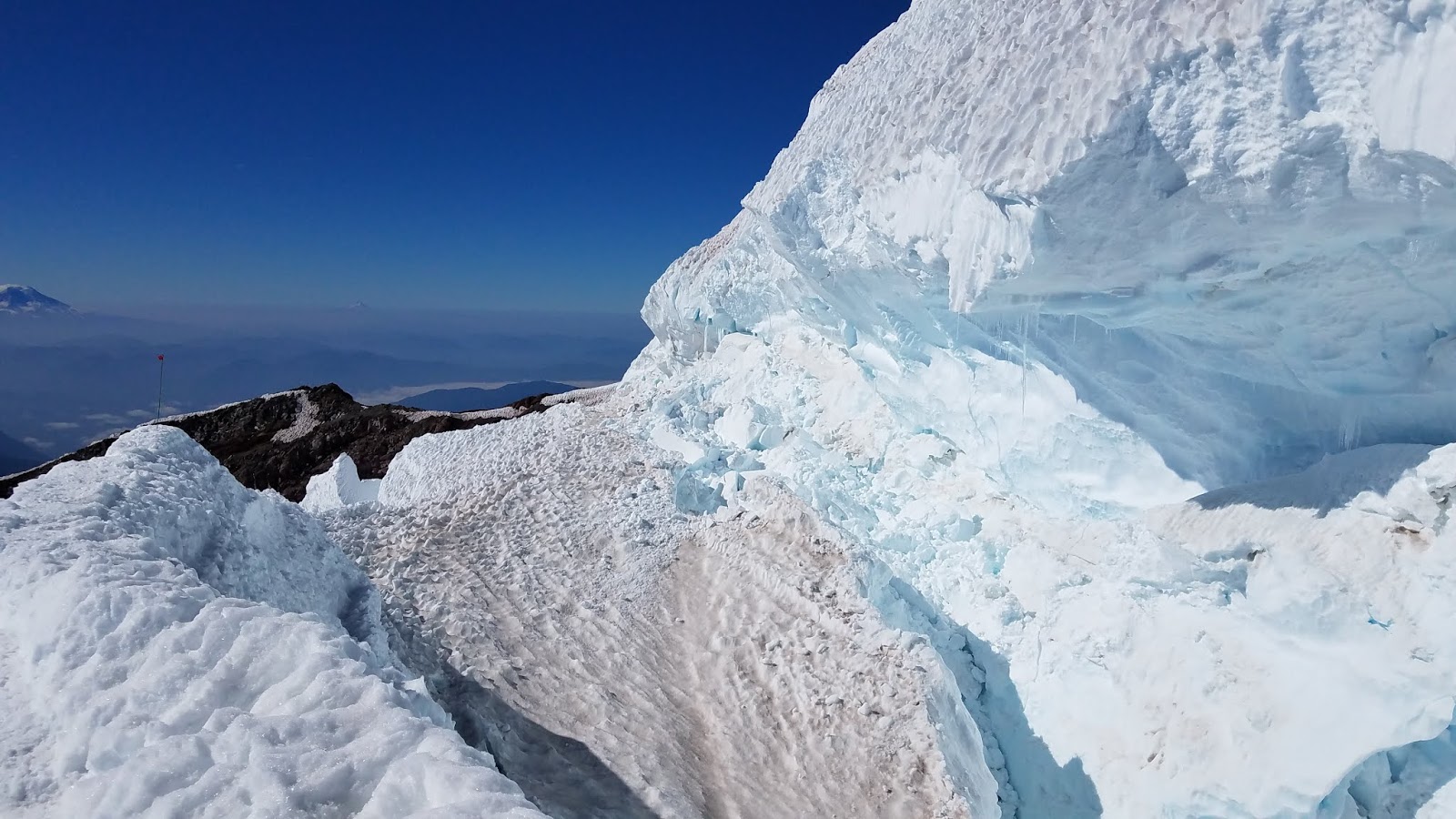
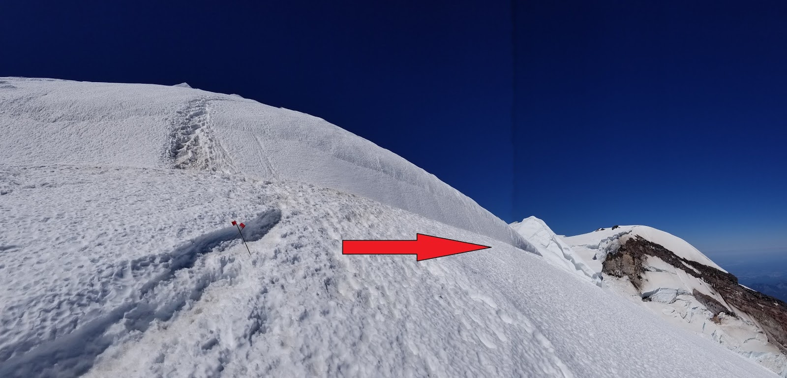
The DC route is largely the same route with many of the same hazards as in the previous post, but with a few small changes. Once to the top of the Cleaver, the route continues climbing uphill for around 300 feet to a large serac jumble (referred to as the popcorn). Where the recent route climbed beneath this feature, the current route travels up and over this formation--which reduced the objective hazard, but by no means resolves the issue and hazards. From this point,  continue climbing towards the Emmons Shoulder, traversing along an exposed fin with a very large crevasse just uphill until faced with a steep side-hill slope that will bring you back to the old route.

Be aware that with the elevated freezing levels and all the warm weather, the upper mountain has been changing very quickly. Serac movement can change the route quickly which may result in the route becomming impassable. As stated in previous blog posts, be ready for things to change rapidly and have a reserve of energy to overcome potential challenges if you happen to come across an route-finding or navigation issue while descending.

For a more detailed description on the entire route, see the previous Blog Post  

A view looking up from the top of the Cleaver

Climbing around the top of the serac feature above the Cleaver

Looking towards the Emmons Shoulder. The Ranger is about to climb onto the fin.

Climbing out onto the Emmons Shoulder with a handline

The route is not without serac hazard.


Tuesday, July 31, 2018

D.C. Route Update 7/29

The only thing that is consistent on the D.C. this year is change. With the recent warm temperatures the route has been evolving rapidly. Where there was once multiple options to navigate through broken up sections there are now only paths with significant exposure to hazards.

The main area of concern is 'The Popcorn' at 12,500 feet. Popcorn is a reference to large blocks of ice stacked up with little support. If one block shifts, all the other ones move as well. This particular popcorn section sits above a large crevasse cavern and thus is not supported from below. Climbers entering the Popcorn expose themselves to both the potential for ice fall from above and for the route to collapse underneath them. Either of these would be an unsurvivable event.

For those that have been following this blog, the 'plug' discussed on the last update has collapsed into the crevasse cavern and the route now travels ~150' further uphill.


Photo of the Popcorn section. Note the large cavern below the ice blocks.


This is a typical low-probability, high-consequence risk management problem. Each climber needs to decide if they choose to accept this risk or not. The rangers at Camp Muir have been instructing climbers to look at the feature for themselves and have a discussion amongst their team about the risk. If any member of the team decides that climbing that section is too hazardous, the whole rope team should respect that decision and descend. Approximately one-third of the teams that make it to the Popcorn have decided that the risk is not acceptable and they have retreated from that point.

A ranger climbs through the Popcorn
 

Additionally, if this area collapses while you are above it, returning to camp will require several thousand feet of extra uphill climbing. The only other known option to return to Camp Muir involves climbing back up to 13,500' and descending to Camp Comfort at the top of Gibraltar Rock. From here, you will have to follow an old, unmarked trail to get back to the Disappointment Cleaver. If you are planning to climb this week, be ready for things to change rapidly and have a reserve of energy to overcome these potential challenges.

Approximate climbing route as of July 29, 2018.

With all the discussion of the route finding issues it's important to note that other hazards still require attention. Rockfall hazard exists in Cathedral Gap as well as getting on/off the base of Disappointment Cleaver. Climbers have been injured by rockfall this summer. Crevasse fall is, of course, an ever present concern on the glaciers as well.

It's important to come to Mt. Rainier with a good understanding of the risks inherent in mountain climbing and the hazardous areas unique to the D.C. route.
 

Monday, July 30, 2018

Emmons Update - July 29, 2018

Here is an update for the Emmons/Winthrop route.  The bulk of the route information is similar to the last blog post.  You can follow this link to access that post.

The main area of concern for the rangers continues to be the bergschrund at 13,200'.  Here the old trail crosses this large crevasse on an ever-shrinking snow bridge.  The old trail is still the easiest to discern but PLEASE DO NOT GO THIS WAY!  This snow bridge looks like it will collapse very soon.  If it collapses while a team is on it the consequences will be catastrophic.

This is the snow bridge that we would like climbers to avoid.

Instead, at the junction at 13,200', look for a fainter boot pack that will take you up and right  (northerly) toward Winthrop Saddle above the upper Winthrop Glacier.  This is the safer route. 

Fork in the road.  13,200'.  You want to go right here, toward the ranger. 
There are still many hollow spots along the Corridor, so use caution.  On Sunday there was a report of an independent climber falling in a crevasse.  Fortunately the individual was uninjured and his partners were able to extricate him.  This is the second reported crevasse fall on the Emmons in two weeks.  In both cases the team was able to self-rescue.  This is commendable.  Parties attempting any route on Rainier must have the equipment and skills to perform crevasse rescue.

Lastly, PLEASE DON'T LEAVE TRASH AT CAMP SCHURMAN (or anywhere on the mountain).  Climbing rangers were a little dismayed at the amount of stuff abandoned near the hut when they arrived Friday.  There was a foam sleeping pad, trash bags, a coffee mug, trash in the bear box which is used for food storage near the hut, etc.  Please remember to pack out all that you pack in to the mountain. 

We're definitely entering late season on the mountain.  Come get it while it's still good.

Thursday, July 26, 2018

Last Weekend in July Update..


Both the Disappointment Cleaver and Emmons/Winthrop Routes have been changing, almost daily, due to shifts in the glacier.  The high freezing levels and uninterrupted sunshine have been cooking things on the upper mountain.  Both of the most recent blog posts for these routes outline the gist of where the route goes and what to expect, but be aware that it can change at anytime.  We encourage climbers to start early on these warm days and stick with an early turn around time to help avoid being in the most hazardous areas during the hottest part of the day.

The weather forecast has a bit of a blip coming up this Friday and Saturday:

.FRIDAY...Sunny. A slight chance of thunderstorms in the
afternoon. Snow level near 12500 feet. 
.FRIDAY NIGHT...Partly cloudy. A slight chance of thunderstorms
and snow showers in the evening, then a slight chance of
thunderstorms after midnight. Snow level near 12500 feet. 
.SATURDAY...Mostly sunny. A slight chance of thunderstorms and
snow showers in the afternoon. Snow level near 12500 feet.  

Be cautious ascending high on the mountain with thunderstorms in the forecast.  They often move over the mountain faster than climbers can descend and can cause a potentially dangerous situation.  Don't climb up into a thunderstorm and if you see thunderstorms approaching the mountain or beginning to build nearby, consider descending back to camp or the parking lot.  It's best not to be the tallest thing out on a wide open snowfield.

July has flown by!  It's starting to be a bit quieter on the mountain, but we still encourage folks to come during the weekdays if possible to avoid the crowds.  Talk to the rangers when you register for your climb about the latest in conditions.  See you on the mountain!

Monday, July 23, 2018

Emmons-Winthrop Update 7/23


The Emmons-Winthrop route remains in typical late July condition. Many crevasses in the Emmons Flats and Corridor areas sport thinning snow bridges and the route is growing more circuitous by the day. The bulk of the route remains unchanged from the previous posts; the route trends climber's left above the Corridor through a large bowl. Expect to make decisions regarding the best route for your team during your attempt.

Light blue indicates the most recent route to the Winthrop Saddle.
The bootpack is quite narrow in places—especially on steep traverses—and it requires careful footwork to avoid catching a crampon on your pants. The consequences of a fall in this terrain are significant. Move slowly and deliberately through this terrain; some parties may wish to use running belays to increase their security.

The bergschrund is on its last legs. Climbing over it is the steepest section of the older route.  It spans roughly 30 feet and the bridge is a mere three feet thick in places. Rangers were able to establish an alternate route to the summit rather than crossing this terrifying feature.

The old boot pack takes you over this....

This option traverses to climber's right (toward Liberty Cap) below the bergschrund and weaves its way through a small trough and open slopes out to the Winthrop Saddle at 13,600'. This recommended option approximates a common path that the Emmons-Winthrop route has followed in previous seasons. The bootpack is currently difficult to discern in this section and is not wanded.

Trend Right.
As July rolls on into August, expect the glaciers on Mount Rainier to continue to present more challenging climbing conditions. Be prepared to navigate complicated terrain, perform crevasse rescue, and give yourself more time overall to complete your summit attempt.

Sunday, July 22, 2018

D.C. Route Update -- 7/22

Ingraham Flats with the Disappointment Cleaver on the right.
Few climbers managed to reach the summit via the Disappointment Cleaver on July 22nd. This was, in part, due to reports from returning climbers early in the day that the route had changed overnight. There were also reports of a bottleneck at a glacial plug around 12,400’--near where climbers leave the top of the Cleaver and climb through a frequently-hollow section of glacier. 

Plug at 12,400' with overhead icefall hazard that is constantly present on the DC route
The morning light allowed a more thorough assessment of the plug. It is possible that some of it had collapsed overnight--what remained intact was narrow, but moderately thick. Nearby glacier features, like thin fins of ice, give the appearance that the plug is poorly supported. With the high freezing levels in the forecast, there is no telling how soon this snow bridge will fall out. Remember to practice conservative decision-making in the mountains and this situation is no exception; it is not advisable to cross tenuous features in late morning or early afternoon conditions once the sun starts softening snow.  For the moment, this route remains a viable option in somewhat typical July condition, excepting weakening snow bridges like these and other hazards inherent in the mountains.

Looking up from the top of Disappointment Cleaver. Note the icefall debris on the left and the crevassed jumble on the right.

However, with this partial collapse and the increasing potential for rapid changes, the guides at Camp Muir have begun talking about other options. Who knows where the route will go as the summer presses on?  Guides are hopeful that the debris from the collapsing bridge and surrounding seracs will eventually fill in the crevasse at 12,400' and allow the route to follow a common summertime path out to the Emmons Shoulder.  If the gaping crevasse doesn't fill in with debris, the guides will likely have to completely rework the route. Time will tell.


Plug at 12,400' from another angle
Please understand that if this bridge fails while your team is above it, your descent to high camp will be a long journey. There is no easy workaround if you return to this bridge and it is no longer passable. In fact, if the bridge collapses while you are above it, returning to camp will require several thousand feet of extra uphill climbing. The only other known option to return to Camp Muir involves climbing back up to 13,500' and descending to Camp Comfort at the top of Gibraltar Rock. From here, you will have to follow the old trail (no markings, wands, ladders, or pickets) and make your way across the recent ice fall debris on the Ingraham Glacier to get back to the Disappointment Cleaver. If you are planning to climb this week, be ready for things to change rapidly and to have a reserve of energy to overcome these potential challenges.

Climbing Ranger descending to the top of the DC