Monday, May 28, 2018

Emmons-Winthrop Update – May 26, 2018


Descending The Corridor with Sun On The Rise. May 26, 2018


The Emmons-Winthrop route is climbing well. The route is in typical condition from Camp Schurman to the top of The Corridor. Above there, a few opening cracks present navigational challenges from 12,000’ to 12,500’ along the north (right) side of the Alpine Meadows (the lower-angle area above The Corridor). There are many tracks in this area that lead to hollow and thin crevasse crossings around 12,500. There are currently no safe crossings along the 12,500’ crevasse except on its north end on the Winthrop Shoulder. Above this crevasse, the upper route is fairly straightforward with variable surface snow conditions. The uppermost portion of the route traverses along climber's right side of the bergschrund towards Liberty Saddle on large fins of snow and ice that are visible from Camp Schurman.  The route then rallies to the saddle and, eventually, the summit itself. 

The climbing route is not wanded, nor well traveled at this point. Come prepared with navigation tools (GPS, altimeter, map/compass) and the skills to use them. It won't take much snow to obscure the nascent bootpack on the route.


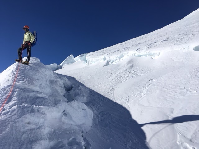
Large and wild glacial fins near the Bergschrund on the Emmons-Winthrop.

Although many parties come to this side of the mountain intent on a ski descent, the route is not in good condition for skiing. Cold and variable snow, replete with wind textured surfaces (e.g. sastrugi) exist above 12,000’ - the East Northeast aspect hasn't been getting the same melt-freeze cycles as the South side. The surface is frequently a mix of breakable wind crust and very firm wind packed snow. Don’t expect the snow surface to soften above 12,000 feet, especially given the low freezing levels forecast for this week. Make conservative decisions when considering skiing the Emmons route –what would be an insignificant fall in a ski resort can easily cascade into an unstoppable slide into an open crevasse. Don’t be afraid to stash skis at lower elevations for use on the descent.


Ice fins and opening crevasses on the upper Emmons-Winthrop route.
Track Log of the Emmons-Winthrop Route on May 26, 2018


Kautz Glacier Report - 5/26/2018

The Kautz Glacier route is in nice early-season condition.  Continuous snow travel can be expected on the approach up the Wilson Gully all the way to The Castle and upper bivy sites.  The short rock step from the upper bivy sites near Camp Hazard down to the Kautz Glacier is filled-in and can be protected or rappelled.  Be sure to evaluate any fixed protection you encounter before using it and consider backing it up (and remove your gear when finished!).  The traverse above the rock step is covered with large debris from a recent ice avalanche off the ice cliffs above -- a good reminder to move efficiently through this area.

Looking at the route from the rock step. 

The ice pitches are still mostly snow-covered.  The lower 'ice pitch' has about 30-40 feet of relatively low-angle, textured mixed snow and ice penitentes.  The climbing is secure here and ice protection is possible.  The rest of the glacier is snow covered.  Above the upper ice chute the navigating appears easy to the top of the Wapowety Cleaver.  Alternatively, it is possible to climb straight up to Point Success.

The upper Kautz Glacier 'ice' chute.  

The view down the lower Kautz Glacier.  The Kautz Cleaver and upper Success Couloir routes look to be in good shape as well. 

Looking up at the Fuhrer Finger. 

Friday, May 25, 2018

Fuhrer Finger Update

There's a crevasse opening up at 12,700 feet above the 'hourglass' on the Fuhrer Finger route that has added great difficulty the climb and made the ski down impassable.  An IMG Guide climbed up through the Fuhrer Finger yesterday (May 25th) and noted that he had to down-climb onto a block in a crevasse and then pitched out the climb to get up the upper wall of the crevasse.  Skiers who've skied the Finger previously also attempted the ski yesterday and were turned around at 12,700' due to this crevasse and ended up ascending back to the Ingraham Direct route to ski down.

The couloir and hourglass section of the route remains passable on foot and skis.

The upper mountain has not been softening at all with the cooler temperatures this week. Parties have reported firm conditions even in the late afternoon above high camps. Skiing the upper mountain is rarely in 'good' condition, and is quite often categorized as 'survival skiing.' This week is no exception.

Please make good decisions about snow conditions, ski conditions, group fitness, roped vs. unroped skiing, and overall suitability of your objective for your group.  Realize that any fall on the upper mountain, even a small tumble, will likely result in an uncontrollable slide with severe consequences. 

Emmons-Winthrop Conditions - May 25

Emmons-Winthrop Glacier from Steamboat Prow. May 24, 2018.
With the White River Road open, the east side of Mount Rainier is starting to see increasing climber and skier traffic. The Emmons-Winthrop has seen some ascents this week and parties are reporting generally favorable travel. There are numerous crevasses opening to wander past, especially above 12,000'. The route is not wanded and has an intermittent bootpack which will quickly become obscured with any new snowfall. Expect to do all of your own navigation; come prepared with a GPS, map/compass/altimeter, and knowledge of how to use them.

Snowy travel in Glacier Basin
The Glacier Basin Trail is a mix of snow and dirt, but is all-snow about 2.5 miles from White River Campground. The Inter Glacier is pretty filled-in and is currently quite smooth. Be cautious and conservative when crossing streams and moats -- give any visible holes a very large berth since the snow is likely to be very thin in the vicinity. Keep your teammates in sight when crossing these hazards and be prepared to extricate a person if they plunge through thinly covered areas. As always, be sure to rope up on the glaciated terrain below Camp Schurman.

Approach from Camp Curtis to Camp Schurman on Emmons Glacier.


Climbing team crossing Emmons Flats.


Sunset Ridge Conditions

Looking up the South Mowich Glacier towards St. Andrews Rock. 
Sunset Ridge is the rimed skyline in the middle of the photo.
Sunset Ridge is currently in good condition.  Overall, the Puyallup & South Mowich Glaciers were navigable and the bergshrund crossings were passable without too much effort to find a suitable bridge, although with the warm weather in the forecast, the lower 'shrund may collapse soon and impede travel to the upper ridge.

Crossing the South Mowich Glacier is straightforward and no major crevasse crossings were required (Photo 1).  From there, we encountered mellow climbing around the bottom buttress of Sunset Ridge up to the bergschrund (Photo 2). We found firm conditions up the 1800' lower "pyramid-face" before gaining the Sunset Ridge proper at 11650'  There is a short section of easier, but technical climbing on the ridge before bumping out climber's left onto the upper Mowich Face (Photo 6).  Once on the face, we found firm 55-60 degree snow with glacier ice a few inches below the surface that accepted ice screws.  This sectioned involved roughly 1300' of front-pointing (Photo 8)  From the top of the face, easy navigation led up to Liberty Cap, and from there, across the saddle to Columbia Crest.

This route involves a fair amount of elevation gain and mileage from the base of the route.  The route itself clocks in around 6400' of gain over 5 miles plus the approach and descent.  It's a big push, but well worth the effort for the views of the western side of the mountain.  That said, the location of Sunset Ridge is one of the more remote locations inside Mount Rainier National Park, so it see's very little traffic.  Expect conditions to be different from this description and come prepared for technical climbing, long days, rock and icefall and the possibility of impassable crevasses or bergshrunds.

The following photos are listed in order starting from the lowest elevation.


Looking up the lower portion of the "Pyramid" on the lower portion of the Sunset Ridge route.  The bergshrund was crossable far climber's right, below the saddle.

Looking downhill from the top of the "lower pyramid" around ~11,500'

Looking down Sunset Ridge. Puyallup Glacier is the large glacier seen below.

Navigating steep snow and rock along Sunset Ridge.

Looking towards the upper Mowich Face.  Minimal snow on the ridge forces the route
onto the face, opposed to following the ridge all the way up to Liberty Cap


Looking down the Upper Mowich Face toward Sunset Ridge
Steep 55-60 degree snow on the upper Mowich Face

Overview of route taken from camp at 8500' on the S. Mowich Glacier to Columbia Crest

Ingraham Direct Route Conditions - May 23

Looking down the Ingraham Glacier towards Camp Comfort and Gibraltar Rock
The Ingraham Direct is remains the preferred climbing route on the south side of the mountain; it is holding in there even with the recent summer-like temperatures we've been experiencing at Mount Rainier National Park.  Currently, the route is roughly 2.9 miles and is still fairly direct.  Lots of recent rockfall was noticed, especially around Cathedral Gap (see photo).  Once past Ingraham Flats, the route ascends the Ingraham Glacier towards Camp Comfort atop Gibraltar Rock.  From this point, the route switchbacks to Columbia Crest with only one notable crevasse crossing around 13,200'.

With warm weather forecast for Memorial Day Weekend, expect both rock and ice fall on the route.  Crevasse bridges that seem stable on the way up will likely soften throughout the day, increasing chances of crevasse falls on the descent.  Keep a heads up, especially while on your descent.

With the busy weekend right around the corner, please have patience with fellow climbers and know that there will be multiple groups ascending and descending at different speeds.  Please be courteous, communicative, and pass other parties in safe locations.  Also DO NOT split up your team on the upper mountain -- keep everyone roped together while climbing above Camp Muir.  If one person in the group feels like they need to turn around, don't send them down alone.

13,200' crevasse bridge


Recent large rockfall below Cathedral Gap

Cowlitz Glacier and Camp Muir.  Notice the extent of the rockfall crossing the existing track.  We recommend moving through this area quickly and keeping an eye out for falling rock.

Current Ingraham Direct route in orange.