Tuesday, July 05, 2022

Ingraham Direct 7/5/22

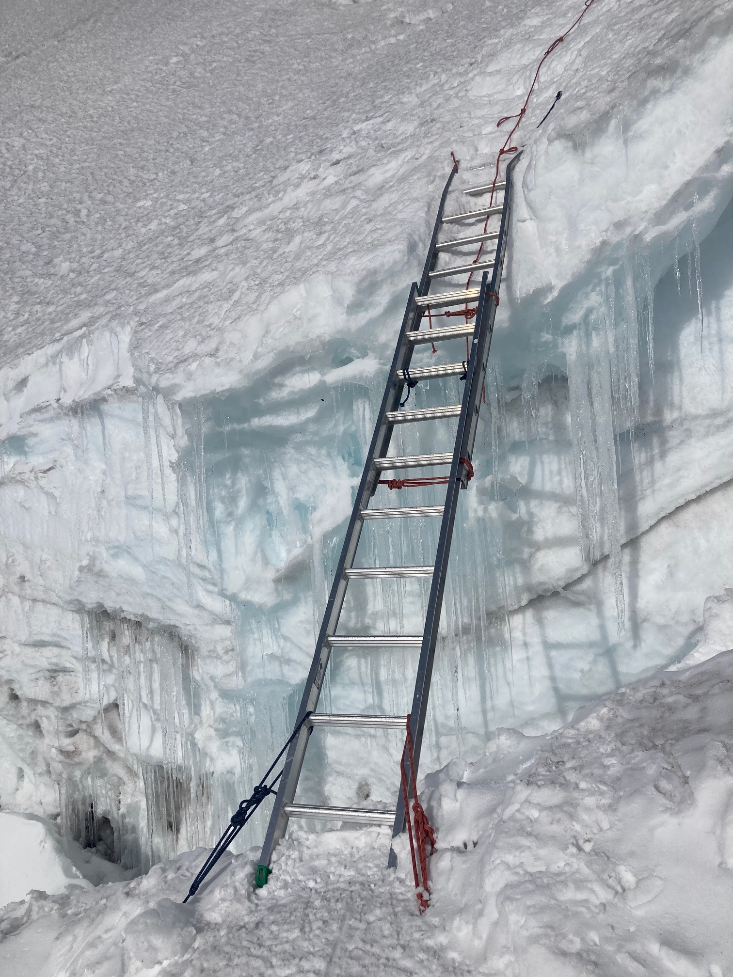
Guided and independent parties are still climbing the Ingraham Direct which is unusual for this point in July. One ladder is in place (see photos) as well as a small plank crossing. More ladders may to go up in the coming days. The route is still in decent condition, though there are many thin snow bridges from 11,000 feet to 13,000. The risk of falling or punching through into a crevasse is greater than normal for this time of year on the 'standard route' out of Camp Muir. When crossing crevasses, remember large steps are OK, but jumping over them is often how people get hurt or fall. If you find yourself with the urge to jump over a crevasse, consider walking to one end or the other to find a reasonable place to cross.  Remember to keep your teammates tight on the rope as they are crossing to reduce the amount of slack in the rope. Parties ascending on skis should know that the surface conditions and the open crevasses are not ideal for skiing down the Ingraham Direct.  Multiple skiers have hiked up their skis and then walked them back down due to "survival" ski conditions.

The freezing levels are remaining low around 9,000 to 10,000 feet for the upcoming days.  but variable weather has been turning some parties around. Expect more challenging weather conditions in the near future - the forecast looks a bit mixed this upcoming week. Parties hoping to summit should be prepared for whiteout navigation, variable weather, and high winds. Recording a track on a GPS device can help with navigation on the way down - and can sometimes be the only way to navigate back down the mountain.


Ladder around 11,700' on the Ingraham Glacier

Looking uphill from Ingraham Flats


Looking towards Gibraltar Rock, climbers approaching the ladder

Looking down the Ingraham Direct

Muir to/from Paradise

If you are traveling to Camp Muir and plan to glissade down use caution. On your ascent, scope out paths without rocks, holes and other hazards.  Also, be sure to check out this navigation sheet to help travel up and down in a whiteout.  Every year parties get lost on the Muir Snowfield in a storm -- don't let this happen to you!  Set a GPS track, have a map downloaded onto your phone ahead of time (there's limited cell service inside the park), and have a plan with your partners if you get separated.  

Two glissade chutes with deep holes at the base; Panorama Point

Sunday, July 03, 2022

Emmons/Winthrop 7/2


Many parties had successful summits in July; reporting mostly good cramponing conditions and an established bootpack to help navigate around crevasses. 

Snowbridges that the main bootpack crossed were starting to weaken with the heat over the weekend and new areas to cross may need to be found. In the alpine meadow zone (around 12,000 to 13,400 feet) very firm cramponing and slick surfaces exist. Many independent parties were looking to ski from the summit. Many did not due to firm, icy, and variable snow conditions near the summit. There are also several large crevasses to avoid.  

Glacier Basin trail to Camp Schurman is losing snow quickly. Patchy snow exists starting at around 5500 feet. Consistent snow starts at Glacier Basin. Some small crevasses are starting to open up on the lower Inter Glacier. Staying roped up isn't the worst idea on the Inter Glacier - crevasse falls are possible!  

It's definitely prime time for climbing the Emmons/Winthrop Glacier route.  As the weather patterns stabilize and the glacier starts to break apart more, this route historically goes "out for the season" sometime in the beginning of August.  Hope to see you up on the eastside soon! 

The route on the Emmons/Winthrop to the summit

Looking up the Inter Glacier from Glacier Basin

Looking down valley from Glacier Basin

Wednesday, June 29, 2022

Ingraham Direct/Disappointment Cleaver Route Conditions

Warm temperatures and clear skies this week are giving way to lowering freezing levels and showers over Fourth of July weekend.

Sunrise over Little Tahoma Peak

Guide services are continuing to climb the Ingraham Direct route at this time. Though not as direct as a couple weeks ago, the route remains in favorable conditions. Summer temperatures are widening crevasses in the 11,500’ to 13,000’ zone. It would not be surprising to see ladders spanning some of these crevasses in the coming days. The serac band around 12,500’ poses some significant icefall hazard on the route, as evidenced by several large ice blocks that have crossed the route. Reduce exposure by climbing in cold conditions, taking breaks before the hazard, and move quickly through these hazard zones. Be patient at bottlenecks and step uphill to allow faster parties to pass on the downhill side.

Guide services have started to consider transitioning to the Disappointment Cleaver route as the crevasses on the Ingraham Glacier widen and icefall hazard increases with summer temperatures. At this time, the cleaver remains pillowed with snow and is rather steep. The surface conditions are firm and may require running protection for fall protection. Due to these concerns, the Ingraham Direct still remains the primary climbing route in the Muir corridor.

Ingraham Flats and Ingraham Direct Route

After warming temperatures this past week, the winter snowpack containing persistent weak layers has stabilized. Wet avalanche problems are the primary concern in the current summer snowpack. Signs of pending wet loose avalanches are increased boot penetration, pinwheels, and roller balls. Wet slab avalanches, of low probability but high consequence, are of concern with high freezing levels, significant water in the snowpack, and nights with no freezing temperature recovery. Reduce exposure by starting early, climbing at night, and monitoring firmness of snowpack.

With the possible return of snowfall this weekend higher on the mountain, slab avalanche problems could present themselves again. Visibility could deteriorate quickly and wands can become invisible in a whiteout. Use GPS tracking while the skies are still clear so it can be used as backup if conditions deteriorate. Slick surface conditions, poor visibility, and increasing winds can turn into a nasty combination quickly.

Summer is here after months of winter weather. Don’t let pent up unsuccessful summit attempts or urgency overtake you. Though the mountain hasn’t been accessible for months, it will still be here for years to come. Be patient at bottlenecks, monitor snow conditions, and respect the weather.

Calm winds, warm temperatures, and good visibility at the summit crater.

Ingraham Direct/Disappointment Cleaver 6/23

 The Ingraham Direct (ID) is moving towards the end of its season. At 11500' just above Ingraham Flats the Disappointment Cleaver (DC) route is being put in by guide services who are anticipating the ID falling out as the weather is warming up. The DC route is crossed off by guide service flagging.

 
As the weather warms the ID will have increased rockfall, icefall, avalanche and crevasse hazard. For now the ID continues to be climbed by guide services and independent parties alike. The cleaver is still blanketed with steep snow; consequential fall zones on the cleaver will push climbers to place running protection. 


Emmons Update 6/28/22

Summer is finally here on Mount Rainier! Freezing levels rose to 14,000' over the weekend removing much of the lingering uncertainty regarding snow stability on the Emmons-Winthrop route. The summit is currently accessible via a multiple route options.

As summer sets in, crevasses will rapidly begin to open and the danger from crevasse fall will increase. Climbers who find themselves on the upper mountain when the snow conditions turn to slush are taking on more risk and should be descending as quickly as is prudent.

The snow on the Inter and lower Emmons glaciers is still finishing up it's spring transition and does not support weight well when warm. Because of this, account for longer-than-usual approach times to camp. There are some crevasses already opening on the Emmons between Camp Curtis and Camp Schurman. The largest of which is no more than 15 feet below camp. 

Crevasse opening up outside of Camp Schurman.  Note the approach path and ski tracks.  This is surprisingly common, and illustrates the need to constantly assess the route.  Just because others have  travelled there before, it doesn't mean it's still safe to do so.  

Multiple route options exist on the upper mountain. The map below shows a route that is quite direct, but gets fairly steep above 13,400'. The other noteworthy option is to traverse out to the Winthrop Saddle at about 13,400' to cross the final bergschrund. Just be aware, the crevasse bridge that makes this variation possible may fall out soon.  Always be prepared for the route to fall out behind you, as you may need to on-sight a new descent path or climb back to the summit and descend an alternate route.

For climbers that are considering climbing Liberty Ridge and the descending down the Emmons-Winthrop, it's always best to know first-hand the descent route and it's possible variations, as it's not always an easy on-sight.

Track from route on 6/25