 |
| View of NEOWISE Comet over Seattle from Camp Schurman |

This blog is maintained by the Climbing Rangers for use by recreational non-guided climbers and skiers. Use these reports as a baseline but plan for changing conditions.
Saturday, July 18, 2020
NEOWISE Comet!

Thursday, July 16, 2020
Disappointment Cleaver Route Update 7/16
Suncupenitente Season
Suncups are bowl-shaped open depressions into a snow surface, normally wider than they are deep. They form closely packed, honeycomb, often hexagonal patterns with sharp narrow ridges separating smoothly concave hollows.
Penitentes, or nieves penitentes (Spanish for "penitent-shaped snows"), are snow formations found at high altitudes. They take the form of elongated, thin blades of hardened snow or ice, closely spaced and pointing towards the general direction of the sun.
The combination of the two, “Suncupenitentes” accurately represents the current conditions on the Muir Snowfield, particularly as one approaches Camp Muir. Are they suncups? Or are the penitentes? Only a credentialed snow scientist would know for sure. In any event, skiing is no longer recommended on the snowfield from the standpoint of sliding quality.
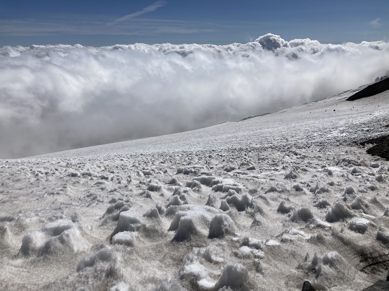 |
Suncupenitentes near Camp Muir, roughly boot top height
|
Presently, conditions up to Ingraham Flats and across to the Cleaver are largely unchanged from the July 7th conditions. The current boot pack ascends from Camp Muir across the Cowlitz Glacier to Cathedral Gap, which is snow-free. From the gap, ascend past Ingraham Flats and climb to "High Crack". This crevasse runs in line with the flow of the glacier, and with the recent warm weather, this "trap-door" crossing is melting out and is thinly bridged. Spend time examining this crevasse crossing. With forecasted 15,000 foot freezing levels this weekend, thin snow bridges may remain soft overnight.
The namesake Disappointment Cleaver has two primary options presently. The Cleaver proper can be climbed directly on rock following the path of least resistance and obvious travel impact. Alternatively, a route has been wanded in the snow on the west side of the ridge. This starts approximately 1/3 the way up the ridge. This terrain is highly suncupenitente’d. Approach this section with caution as any rockfall will funnel directly onto the climbing route below.
Once above the Cleaver, the route is now taking a more direct line than the Camp Comfort variation that has been taken in weeks past. While the Camp Comfort variation still goes, the crevasse hazards are growing and the terrain between the primary crevasses at 12,800ft and 13,500ft is steep and firm. A fall without running protection could result in catastrophic consequences. Both routes were wanded at the time of this writing so it is still possible to accidentally wander onto the Camp Comfort route. A map with a recent track of the direct route can be found below.
Ultimately, the DC is still a remote and rugged route with very little traffic compared to a typical year. Teams should not rely on another party’s wands for navigation. Fe prepared and self-sufficient with GPS navigation and an emergency kit to survive 24 hours in a storm at high altitude.
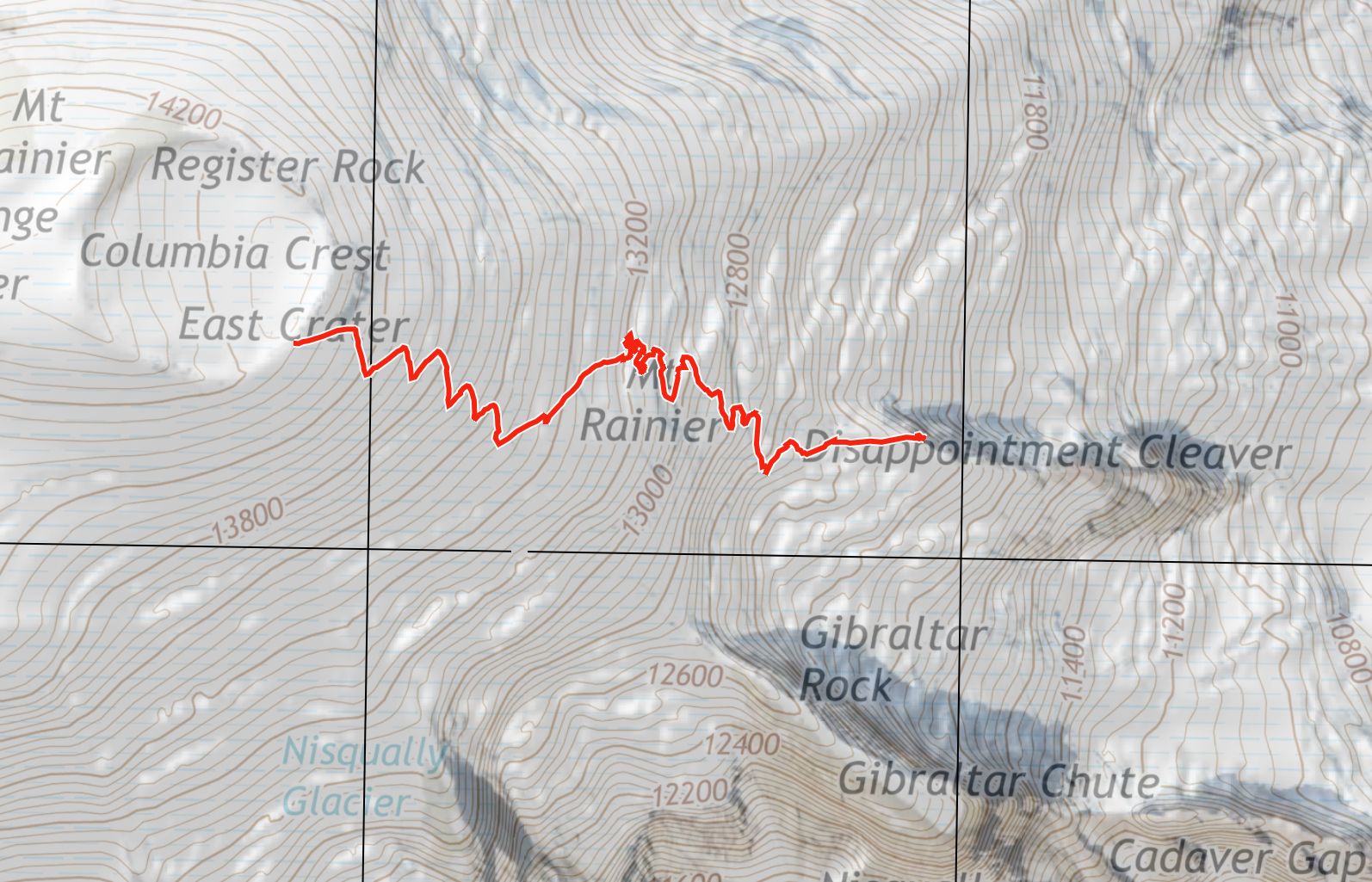 |
| Recent track log of the direct variation (not the Camp Comfort variation) |
 |
12,800 foot crevasse hazard on the Camp Comfort variation
|
Emmons-Winthrop Route Update 7/14
The Emmons-Winthrop and Camp Schurman have been seeing a good deal of traffic in the past week. Many parties have been successful on the route, with weather being the main factor preventing climbers from reaching the summit. Summer does seem to have arrived and with it some more stable and warm weather going forward. Good climbing conditions should continue on the Emmons for the up-coming weeks.
 |
| Recent track log (note the traverse to Liberty Saddle) |
From Camp Schurman the route follows the previously blogged "standard" route up through the Corridor. With warm temps and thinning snow, beware of weak snow bridges just out of Camp Schurman through the lower Corridor. At the top of the Corridor, continue right through a small serac jumble and out into the large open slopes of the Alpine Meadow. In the Meadow you will come upon several large crevasses to cross. In almost all cases the most prominent boot pack will take you to a impassable location or a sketchy crossing. A little hunting for a place to end-run or step across the crack will take you to a safer crossing. Many rescues occur every year from climbers who decide to jump/leap/hop a crevasse in crampons. Unlike popular films, this action typically results in a lower leg injury and an inability to descend the rest of the route.
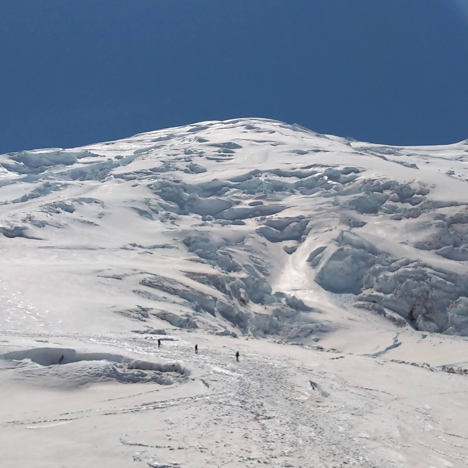 |
| Climbers returning to Schurman |
At 13,400 feet, the most significant change to the route occurs. The previous path ascending through the Bergschrund is no longer viable. Instead, take a hard right and traverse out to Liberty Saddle. While this does add length to the climb, the terrain is significantly lower angle and climbers have been making good time. Large crevasses exist as you move into the saddle. Take the time to assess your crossings and find one you feel comfortable - don't just follow existing foot prints. From the Winthrop Saddle proceed up the final pitch to the summit.
 |
| View across the 13,400 traverse to the Winthrop Saddle |
Descend the same way, and use a GPS track (the one your team recorded on the way up..) to bring you back to the crevasse crossings identified on the way up. If you are using wands, remember to pick them up on you decent.
As a final note; please camp on the snow at Camp Schurman. The same policy is in effect at Camp Muir, but a reminder is needed. The rocky areas at both camps are used for aviation operations. If a rescue was needed, the park helicopter would not be able to land with tents and cookware in the way.
 |
| Camp on the snow (note the existing tent platforms) |
Happy Climbing!
Tuesday, July 07, 2020
DC Conditions July 7th
Conditions on the Disappointment Cleaver route are largely unchanged from the previous post. The current boot pack ascends from Camp Muir across the Cowlitz Glacier to Cathedral Gap, which is largely snow-free now. From the gap, ascend past Ingraham Flats and climb to "High Crack". This crevasse runs in line with the flow of the glacier, and with the recent warm weather, this "trap-door" crossing is melting out and is thinly bridged. Spend time examining this crevasse crossing, as the safest area to cross may not be the place where the boot pack leads to.
The cleaver proper is largely navigable without maneuvering over snow by staying on the ridge crest. Without a shoveled walkway, ascending the steep snow on the side of the cleaver may be difficult when the snow is frozen and firm. A slip or fall in this area may lead to an unrecoverable slide.
Once atop the cleaver, climbers will see an leftward rising traverse to Camp Comfort. This traverse requires moving through steep snow which may warrant placing running protection, depending on parties comfort in this type of terrain. After a mandatory crevasse crossing at the top of this steep traverse, climbers will be met with a straightforward climb to the crater rim, with only one notable hollow crevasse crossing around 13,300'. Again, with these crossings, spend time examining different options for navigating these features, as the existing foot path may not be the safest option to cross.
With no helpful route adjuncts like ladders, fixed lines, fixed pickets or shoveled walkway, the DC route climbs like a non-standard, mountaineering route. Climbers should aim to be self sufficient, and comfortable maneuvering steep snow and knowledgeable in placing running protection to add security to the rope team while navigating crevasse crossings and steep traverses.
As always, when on the mountain, please use the provided blue bags when a restroom is not available. We appreciate you're cooperation and your understanding that it takes a community to keep the mountain clean and enjoyable for everyone.
Safe climbing, and we look forward to seeing you on your next visit!
The cleaver proper is largely navigable without maneuvering over snow by staying on the ridge crest. Without a shoveled walkway, ascending the steep snow on the side of the cleaver may be difficult when the snow is frozen and firm. A slip or fall in this area may lead to an unrecoverable slide.
Once atop the cleaver, climbers will see an leftward rising traverse to Camp Comfort. This traverse requires moving through steep snow which may warrant placing running protection, depending on parties comfort in this type of terrain. After a mandatory crevasse crossing at the top of this steep traverse, climbers will be met with a straightforward climb to the crater rim, with only one notable hollow crevasse crossing around 13,300'. Again, with these crossings, spend time examining different options for navigating these features, as the existing foot path may not be the safest option to cross.
With no helpful route adjuncts like ladders, fixed lines, fixed pickets or shoveled walkway, the DC route climbs like a non-standard, mountaineering route. Climbers should aim to be self sufficient, and comfortable maneuvering steep snow and knowledgeable in placing running protection to add security to the rope team while navigating crevasse crossings and steep traverses.
As always, when on the mountain, please use the provided blue bags when a restroom is not available. We appreciate you're cooperation and your understanding that it takes a community to keep the mountain clean and enjoyable for everyone.
Safe climbing, and we look forward to seeing you on your next visit!
 |
| The Disappointment Cleaver as viewed from Ingraham Flats. |
 |
| Looking towards Camp Comfort and the steep left hand gaining traverse. View from the top of the Cleaver |
Monday, July 06, 2020
Glissading!
The Basics
It is a fun, fast, and efficient way to get down, especially when the snow melts out juuust enough: too little snow to ski and too much snow to walk. However, as the rangers patrol the mountain, we've seen a number of golden glissading rules broken. Some with minimal consequences and others with more severe, from lost gear to fractured bones and head injuries. So as a refresher, here are the basics for making your glissade a fun and safe descent.
1. Look at your line. Are you on a glacier right now? Generally a bad idea to be sitting low to the ground, moving fast if you might have crevasses coming up. Even the Inter Glacier has some good size holes just under a thin bridge or past a blind roll. Just because there's a trench from previous glissades, doesn't mean it's a smart or safe line to follow. Do not glissade if you cannot see a safe runout at the bottom AND do not glissade on the upper mountain or when you are roped up.
2. Take your crampons off and wear a helmet. If you value your knees, ankles, and head. It's easy to catch a point when your going fast and next thing you know you flipped around to be flying down face first with a sprained or broken ankle.
3. Have your ice axe ready and know how to self-arrest. On steeper pitches, it is easy to get going faster than you mean to or expect. Make sure you can stop yourself so the rocks at the bottom don't.
4 Keep your pack tight and clean. A lot of gear has popped up in those glissade trenches. It can leave you rather thirsty when you get to the bottom and find your water bottle gone. Or even worse, when the one strap that was holding your tent breaks, and you get to the bottom without your $500 shelter. If it looks like you're having a garage sale of gear on your pack, it's likely to become a yard sale on the mountain.
It is a fun, fast, and efficient way to get down, especially when the snow melts out juuust enough: too little snow to ski and too much snow to walk. However, as the rangers patrol the mountain, we've seen a number of golden glissading rules broken. Some with minimal consequences and others with more severe, from lost gear to fractured bones and head injuries. So as a refresher, here are the basics for making your glissade a fun and safe descent.
1. Look at your line. Are you on a glacier right now? Generally a bad idea to be sitting low to the ground, moving fast if you might have crevasses coming up. Even the Inter Glacier has some good size holes just under a thin bridge or past a blind roll. Just because there's a trench from previous glissades, doesn't mean it's a smart or safe line to follow. Do not glissade if you cannot see a safe runout at the bottom AND do not glissade on the upper mountain or when you are roped up.
2. Take your crampons off and wear a helmet. If you value your knees, ankles, and head. It's easy to catch a point when your going fast and next thing you know you flipped around to be flying down face first with a sprained or broken ankle.
3. Have your ice axe ready and know how to self-arrest. On steeper pitches, it is easy to get going faster than you mean to or expect. Make sure you can stop yourself so the rocks at the bottom don't.
4 Keep your pack tight and clean. A lot of gear has popped up in those glissade trenches. It can leave you rather thirsty when you get to the bottom and find your water bottle gone. Or even worse, when the one strap that was holding your tent breaks, and you get to the bottom without your $500 shelter. If it looks like you're having a garage sale of gear on your pack, it's likely to become a yard sale on the mountain.
 |
| Glissade track down Muir Snowfield |
Friday, July 03, 2020
DC update July 1, 2020
Rangers and independent climbers reached the summit from Camp Muir on June 30th via the Disappointment Cleaver Route. Surface conditions were cold and firm. The snow was nicely "cramponable," but a slip and fall would be difficult to arrest. This will likely be the case for the next few days with high winds and low temps. The current, frozen nature of the upper mountain (freezing levels below 10,000 feet) allowed climbers to cross some snow bridges that may be unstable or collapse as the weather warms up.
Camp Muir to Ingraham Flats
The Cowlitz Glacier is in good shape and the route to the flats is straightforward. Remember to move efficiently below Cathedral Rock to the scree of Cathedral Gap, as this area is prone to rockfall. The walk from the top of the Gap to the usual Ingraham Flats camp does not involve crossing any open crevasses.
Ingraham Flats to the Disappointment Cleaver
Getting on to the cleaver from the flats starts by end running a series of open cracks. The snow bridges that currently allow passage from the middle of the Ingraham Glacier to the cleaver are thin and will become less stable with warmer temps. Consider belaying if the bridges are less than ideal, especially on the way down when bridges are softer later in the heat of the day.
There is a snow ramp that leads right to the "Backboard" of the Disappointment Cleaver. The walking is straightforward, but extremely consequential. A slip here could result in a fall into a huge crevasse. Consider placing pickets for running protection.
The Disappointment Cleaver
The path of least resistance up the cleaver takes you to the nose, up the nose in a few switchbacks, then out to the snow, climber's left. Diligent awareness is rewarded with ease of travel on the cleaver. The path is subtle, and typically 3rd Class (you shouldn't ever be climbing with your arms), and staying on the well-trodden route generates far less rockfall than the more exposed terrain.
Top of the Cleaver to the Summit Crater
Rangers visually identified three potential routes from the top of the cleaver to the summit crater. The left most (blue) route is the current line of ascent for most parties.
Blue Route - This route works towards Camp Comfort to cross a wide crevasse. The line depicts the general area of the best bridge. Above Camp Comfort there is broken terrain to navigate. The route ascends fall line from Comfort end running several crevasses. There may be a more straightforward route climbers left, characterized by a short section of steeper snow. After this broken section the route ascends to the crater without running into any major crevasse crossings.
Red Route – This was the route last summer. From the top of the Cleaver it looks like it may be viable again this year.
Green Route – A set of tracks from a party that possibly summited. They lead to a bridge over a crack then out of sight. They’re in the same area where the standard route has gone up in years past.
The Message Worth Repeating
Come prepared to be completely self-reliant on Mount Rainier this season. Experienced climbers have established that the Disappointment Cleaver is currently a viable route, but this does not mean that it is the manicured route that it normally is - this is for a variety of reasons, but mostly due to the guide services not currently maintaining a boot pack. Because of firm conditions there isn’t even a set of boot prints above 13,000 feet. Mount Rainier has always been a complex, glaciated, high-altitude mountain and that is much more apparent this year with absent the talented guides and limited independent climbers. A team planning to climb this summer must know how to navigate in any weather and problem solve crevasse crossings.
Camp Muir to Ingraham Flats
The Cowlitz Glacier is in good shape and the route to the flats is straightforward. Remember to move efficiently below Cathedral Rock to the scree of Cathedral Gap, as this area is prone to rockfall. The walk from the top of the Gap to the usual Ingraham Flats camp does not involve crossing any open crevasses.
Ingraham Flats to the Disappointment Cleaver
Getting on to the cleaver from the flats starts by end running a series of open cracks. The snow bridges that currently allow passage from the middle of the Ingraham Glacier to the cleaver are thin and will become less stable with warmer temps. Consider belaying if the bridges are less than ideal, especially on the way down when bridges are softer later in the heat of the day.
There is a snow ramp that leads right to the "Backboard" of the Disappointment Cleaver. The walking is straightforward, but extremely consequential. A slip here could result in a fall into a huge crevasse. Consider placing pickets for running protection.
The Disappointment Cleaver
The path of least resistance up the cleaver takes you to the nose, up the nose in a few switchbacks, then out to the snow, climber's left. Diligent awareness is rewarded with ease of travel on the cleaver. The path is subtle, and typically 3rd Class (you shouldn't ever be climbing with your arms), and staying on the well-trodden route generates far less rockfall than the more exposed terrain.
Top of the Cleaver to the Summit Crater
Rangers visually identified three potential routes from the top of the cleaver to the summit crater. The left most (blue) route is the current line of ascent for most parties.
 |
| Possible routes from the top of the Cleaver |
Red Route – This was the route last summer. From the top of the Cleaver it looks like it may be viable again this year.
Green Route – A set of tracks from a party that possibly summited. They lead to a bridge over a crack then out of sight. They’re in the same area where the standard route has gone up in years past.
The Message Worth Repeating
Come prepared to be completely self-reliant on Mount Rainier this season. Experienced climbers have established that the Disappointment Cleaver is currently a viable route, but this does not mean that it is the manicured route that it normally is - this is for a variety of reasons, but mostly due to the guide services not currently maintaining a boot pack. Because of firm conditions there isn’t even a set of boot prints above 13,000 feet. Mount Rainier has always been a complex, glaciated, high-altitude mountain and that is much more apparent this year with absent the talented guides and limited independent climbers. A team planning to climb this summer must know how to navigate in any weather and problem solve crevasse crossings.
Subscribe to:
Posts (Atom)