Monday, August 08, 2016

Summer Weather Forecasts vs. Winter Weather Forecasts

Weather is one of the most important factors when you consider climbing Mt. Rainier.  Usually, July and August tend to be reliably good weather and most folks experience favorable climbing conditions during this period.

This year, the weather has been predictably less good.  Not bad?  Well, there have been bad days, but many of the predicted poor weather periods have been somewhat less intense than what many of the forecasted models have indicated - or at least how I would interpret them in the winter.

Last Monday, because of the models and forecasts, I scrubbed my planned trip to Camp Schurman thinking it was going to be poor weather.  It ended up being good enough to get up to Camp Schurman easily.  I should've gone.

So I thought I'd show some of the forecast tools I use, and offer show what the actual conditions are compared to what the models currently say.  This may help us interpret them.

First of all, I look at the UW MM5 WRF-GFS 36km 500mb Temp/Pressure/Winds model.  Here.  The model for this hour looks like this:


This has been a fairly typical weather pattern this summer.  Low pressure centers have been developing in the Gulf of Alaska and tracking down the BC coast to end up right over western Washington.  This is generally bad and brings cool, moist, and unstable air to the area.
 
Next, I look at the UW WRF-GFS 4km Profile for Mt. Rainier.  Here.  It is a vertical cross section of the atmosphere.  This is what it looks like for the current forecast period:
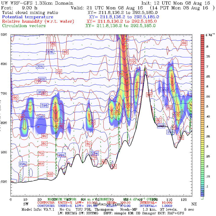


The elevational profile of this graph is roughly from 0 feet to around 16,000 feet.  The rainbow colors are the presence of clouds.  So currently, at Camp Schurman, I would be looking at the right part of this picture, near what looks like a 'peak'. 
 
Next I like to cross reference these models with a different view of the same model inputs, the point data meteograms from the NWS.  Here.  This is what it looked like for this forecast period:
 
 
You can see right now that we are 'peaked' for precipitation and cloudiness (middle graph / brown and blue lines respectively).  The bottom graph indicates lightning!
 
The temperature / winds aloft forecasts was for calm winds.  Here.  I think this was probably the most important forecast component.  High winds in the forecast would've made things much more difficult and hard to manage myself.
 
What did I get on the way up this morning?
 
At 08:30 in White River, I had mostly cloudy skies, with a few sun breaks - all the way hiking in to the toe of the Inter Glacier at 7600 feet.  It began to snow lightly at first, then moderately.  Winds, from the north at 5-10 mph.  Snow level was about 8000.  It pretty much stayed like this all the way to Schurman.  It wasn't bad, at all.  Here's what it was like in Glacier Basin:
 
Here's a picture of what I'm looking at at Camp Schuman currently:
 
Here's a picture of the Camp Muir webcam, right now:
 
 
Conclusion:
 
Yes, the visibility was reduced to 200 yards.  Yes, I got a little snow on me.  But it was generally a good hike up!  If you have a GPS and can use it like a boss, or are experienced with a map and compass and are prepared (dressed) for snow falling, this isn't horrible weather to navigate in.  The guide services were in the area with me (I heard them, but seldom saw them) and made it up where they are currently digging tent platforms.  So the guides had a decent ascent up this morning, too.
 
In my experience, the weather forecast resources are pretty right on.  However, I'm often reminded that the summer softens, somewhat, the blow of the hammer of the gods.  In the winter, this forecast would likely have deterred me, wind or no wind.

** Update ** Plus, I just heard that RMI summitted today.  So....
 
I'm glad I came up today!
 
- Stefan
 

Tuesday, July 26, 2016

Late-July Prime Time

Busy Weekend at Camp Muir
It's that time of year again!  Summer weather has arrived with the hottest day in July predicted to be this upcoming Friday.  The two standard routes on either side of the mountain are still in great shape (but changing daily due to the hot weather).  And the daylight still lasts for over 15 hours (sunrise around 05:30 and sunsets around 21:00).  Climbing conditions are great!

Climbing early is important on these hot sunny days.  Snow bridges across crevasses weaken, seracs fall more often, and rocks frozen in place melt out during the middle of the day.  Try to be off the hazardous parts of the routes by noon.

Another tip for this time of year is to climb during the middle of the week.  Weekends can be crowded, and the opportunity of experiencing some "solitude" of climbing high in the alpine zone can be tough to get.  Plan your trip around the middle of the week for less crowds, quiet camping, and less jams on the route.  See you on the mountain!

Friday, July 08, 2016

Weather Windows

What is the weather doing on Mount Rainier? The age old questions that is on everyone mind when they come to climb the mountain, or is it? Many climbers plan months in advance, travel long distances, and sacrifice many other things to make their one trip to climb the Mountain. No matter how much planning goes into a trip their are always those unexpected obstacles we can't control like the weather. So what are you going to do about it?
Early Spring Conditions on Mount Rainier
There are so many weather tools out their today that provide us with the latest and greatest forecast, giving hour by hour in-depth information, but many of us don't know how to read or have the time to learn how to interpret these fancy graphs and flow charts.  So many climbers just ask the expert when is the best time to climb while they are here on their trip. What is my weather window? The new age question climber want to know.
So what is a weather window and how does it relate to climbing Mount Rainier? Many new aspiring mountaineers have preconceived ideas of what this may encompass. When do I start? How many hours? What is my turn around time? All good thoughts but in the grand scheme these questions are small picture thinking.  Weather windows at Mount Rainier should be measured in days not hours. The vast majority of people attempting a climb will take 3 days, and on the summit day from a high camp will take most of a day (8-14 hours) to complete.  Big picture high pressure vs. low pressure weather patterns are important to pay attention to. High pressure weather systems (called ridges) will provide you with the best weather window for making a successful climb. Climbing during a low pressure weather systems (call troughs) can have its successes but can be limited and challenging in possibly hazardous conditions.
Make sure to check the synopsis paragraph on the Mount Rainier Recreational Forecast
It will give you best up to date big picture view of what is happening at Mount Rainier and the surrounding area.

Tuesday, June 28, 2016

Summer on the Horizon

As we come to the end of June many thoughts flood our minds like where did the time go? Summer is finally here - and what, the 4th of July is next week?  That's right folks, its time to get your bags packed and get on up to Mount Rainier for summer fun. The weather is forecasted for a high pressure system starting tomorrow through the end of the week! A great way to kick of  the beginning of July and the summer climbing season on the mountain. Make sure you get in early to register as high camps have been filling up quickly.  Climbers can register and talk to a ranger at the Climbing Information Center in Paradise. It opens at 7am and closes at 4:30pm. You can also register for your climb at the Jackson Visitor Center in Paradise, the Wilderness Information Center in Longmire, and the White River Ranger Station at the entrance to White River.  Also - the Mowich Lake Road opening is planned for July 1st.  Climbers headed to the north side of the mountain can register at the Carbon River Ranger Station. 

The climbing rangers have been up preparing camps for the busy summer ahead. From making repairs to damaged doors and windows to replacing medical supplies and empty fuel tanks. A project to improve communication at camp Schurman has been in the works for awhile now and should come online this coming week. This new communication infrastructure will assist in planning a response for emergencies on the mountain.  Projects like this are mainly due to donations to our program via the Washington National Parks Fund.  We'd like to give them a big shout out for all the support they've given to Mount Rainier. 

This is the busiest time up high for a reason.  Both the weather patterns and route conditions on the standard climbs line up to be as good as they get in July.  We hope to see you up on the mountain!

Wednesday, June 22, 2016

This Weekend's Weather and Avalanche Guess

This weekend's avalanche and weather guess:

Alrighty, we're getting a ton of phone calls about what we think the weather is going to do this weekend.  Here's my best guess:

First:  Use this forecast model from the University of Washington.  It shows the pressure systems at the 500mb heights (approx 17,000 feet).  You can see the upper level low pressure circulating and creeping towards Washington State.  The upper level low pressure has been creating unstable air and has been the source of much of our precipitation and clouds over the last couple of weeks.  As the low ciculates, grabs moisture from the ocean, it's already cool, and it brings it right to the cascades.  As the moisture goes over the mountains, it is cooled as it is forced up, which it will readily do because of the already present unstable low pressure system.  That causes the clouds and precipitation.


The next model can be accessed here: University of Washington 4/3km Profile.  This model is a x-section of the atmosphere from 0 - approximately 17,000 feet.  The red lines are humidities.  Here you can see the effect of surface warming each day and the low level instability that creates. 


The two models give a good clue that there is some crazy unstable air at the surface and up high that we are going to have to deal with beginning this evening through as far as we can see into Saturday.  This is a contrast to the summer upper level high pressure ridges that dominate the PNW weather.  There is often each day in the summer, surface low pressure over eastern washinton that sucks in cool marine air from the ocean.  That gives us lower level clouds and fair skies above.

This system is different.  There is upper AND lower level low pressure giving high high lapse rates that make clouds and precipitation probable along Mt. Rainier's entire elevational profile.

So do proceed with caution.  If you're bent on coming out for a try, please bring some navigational aids like a GPS and a compass and map and know how to use them.  Bring extra warm clothes and the sturdier tent.  Get a good weather briefing from the CIC before you head up.

With snowfall and precipitation and wind comes avalanche danger.  No one issues an avalanche forecast for Mt. Rainier in June.  However, there are plenty of anecdotal observations coming in from rangers, climbers, and guides.  Yes, there is some observed instability over the last two days.  Easy to moderate failures have been observed both yesterday and the day before at and above 11,000.  However, climbers did summit yesterday and today on the disappointment cleaver.

I anticipate that through the next 48 hours, climbing above high camps will be limited.  It's still too soon to tell about Saturday night and Sunday.

- Stefan

Sunday, June 19, 2016

Come Prepared and in the Know...

The weather over the past week here at Mt. Rainier has been more indicative of what we would see in early spring than mid June.  We recently received a substantial amount of new snow at elevations above 8000'.  What this means is the snow pack on the upper mountain is different than what folks normally see in June.  Large drifted pockets of unconsolidated snow create hazardous and tiring conditions for traveling.  We highly encourage climbers to have knowledge of avalanche assessment, as well as dialed partner rescue skills using a transceiver, probe and shovel.

Heavily traveled routes such as the DC and the Emmons are no different than any other routes on the mountain in regards to weather and avalanche hazard.  Just because other climbing parties are ascending with you does not make the route safe.  Use your sense of general mountain awareness and don't climb blindly into hazardous terrain.  If you have a feeling that avalanche danger is higher than what you're comfortable with, or that weather might be moving in sooner than you had thought, we encourage you to descend.  Mt. Rainier will be here for quite a while, and it's not worth risking your life if conditions aren't optimal.

Lastly, when you do climb, think about throwing in a large puffy, rescue tarp, shovel (in addition to a tranceiver and a probe), stove and extra food into your pack.  If the weather turns south and you end up having to spend the night out on the upper mountain, you're chances of survival are largely increased.  Consider laying a track of your ascent on your GPS, so if the weather moves in and visibility decreases, you'll have a detailed descent route to find your way back to camp.

Even though we're moving out of this most recent storm cycle, keep in mind that with the upcoming warm days, avalanche danger will spike prior to snow pack consolidation, and there most likely won't be splitter high pressure like we're used to seeing.

Come prepared so you can come back again!