

Looking up through the sea of penitentes towards the ice headwall from just above the cleaver. 8/8/23
It's August on Mt. Rainier and there's no two ways about it! With a number of successful summits, and an almost even number of parties spinning due to conditional challenges and inclement weather, the mountain is telling us it's starting to wind down for the season.

View down towards the top of the Disappointment Cleaver itself. Note the faint trail through the penitente and light fresh dusting of snow. Precipitation has come on the upper mountain without being in some forecasts lately. 8/8/23
Route Overview:
The route as it stands is long and circuitous — it is currently 3.4 miles with 4000' of elevation gain coming from Camp Muir just to the summit crater. That's about a 7 mile round trip adventure at altitude high camp to high camp. If you've climbed the DC earlier in the season, this will not be the same type of experience. Be prepared to go up to go down, and down to go up! Due to weaving between the many large crevasses, you'll find yourself losing and regaining elevation a number of times on the ascent and descent. While the route has a boot pack in place along with wands from guide services, these navigational aids are not enough to climb the route. With new precipitation and high winds as experienced this past weekend, the bootpack can become less obvious and covered with new snow, and wands blown down. There are also older junctions from different iterations of the route that can throw one off when navigating down in low visibility conditions if you do not have a track from your ascent to follow. Be sure to have some sort of personal GPS software downloaded on your phone (ex:CalTopo, Gaia, FatMap, etc. all have free versions with this function) and start tracking as soon as you leave Camp Muir. This way if you find yourself in a whiteout on your descent, you will have a path to follow even with low visibility! See it as cheap insurance that could save your life, if not save you from an epic descent in miserable conditions.

A screenshot of the route tracked from Camp Muir to the summit crater climbed on 8/8/23 with Gaia GPS. Travel to the true summit then back to the crater rim will take quite a bit of additional time.
Feature to Feature Updates (in order climbing from Muir to Summit):
- The Cowlitz: Leaving Camp Muir, the Cowlitz Glacier is opening up quite a bit with some sizable crevasses. There is a significant one just before the transition to the rocks below Cathedral Gap that in higher snow years does not open up. The traverse is now lower to avoid this, gaining the rocks below the crack. Know that as soon as you're leaving camp, you're stepping out onto a real glacier with real crevasse fall potential. Additionally, there is quite high objective overhead rockfall hazard from Gibraltar and Cathedral rocks when crossing the Cowlitz, so be sure to move through this terrain efficiently.
- High Crack (~11,300'): As you climb out of Ingraham Flats, the first notable feature you come to before entering the Ice Box and Bowling Alley is a very large longitudinal crevasse, or crack that runs up and down on the mountain (glacial anatomy typically causes glaciers to have cross-slope crevasses, as the ice is stretched out over rolls on the hill side). This vertical crevasse is often referred to as "High Crack", and here is the first ladder crossing of the route. After this, you move into the Ice Box and Bowling Alley, named for their overhead hazards. Move through these efficiently as well.
- Getting onto the Cleaver: Due to high temperatures and the lower snow year, the transition from the glacier to get onto the cleaver has been an issue this year, and continues to be one of the condition-dependent navigational cruxes of the route. In the two or so weeks, there has been a reroute across a narrow section of ice, that then gains the cleaver on some quickly melting, and thin, small snow and ice features. This traverse is vulnerable to the incoming high temperatures and will pose more and more of a challenge as the season continues on. There is not currently a good way to protect this traverse. The cleaver itself is free of snow.
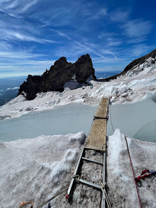
- Traverse out to the Emmons Shoulder (~12,800'): There were 3 route adjuncts, or pieces of equipment that are in place to provide easier travel, above the Cleaver on 8/8/23. Consistent with our update a little more than a week ago, there is one adjunct in the form of a ladder crossing at 12,800' right before the traverse begins. Following this, there is a single plank to cross a widening smaller crack. Then, there is another series of three ladders latched together to cross a matrix of cathedraled cracks at 12,900' which has gotten significantly more hollow and undercut since our last update. Look at the comparison photos below to see just how much a glacier can change in two weeks late in the season! As with any fixed gear on the route, while the guide services place these adjuncts, it is not their job to guarantee that they are safe for you to use — only their clients. Adjunct stability can change throughout the day. This means that before crossing any adjunct, be sure to evaluate the structural integrity of what they are placed on. If you do not think it's safe, do not use it! Your safety is in your hands, not on the guide services.
Initial ladder crossing above the Cleaver near 12,800' on the descent. (8/8/23)

The single plank crossing between 12,800' and 12,900' (8/8/23)

The 12,900' triple ladder crossing as of 8/8/23. Note the undercut and "cathedraled" nature of the bridge across the crack.

The same ladder crossing at 12,900' on 7/23/23, just two weeks prior. Notice the significantly higher amount of snow and ice present than in the last photo.
Other considerations:
There have been a handful of fixed protection pieces on the route to clip into on more exposed sections above the Cleaver in the form of pickets placed by guide services. If you bring your own alpine draws (sling with two carabiners) you can utilize these pieces, however know that it is your responsibility to evaluate if these pickets are still safe to trust. Feel free to reset them if they are melting out, but don't move or take them. The number of pieces of fixed pro on the upper mountain has been fluctuating, so there may be none there when you climb.
There have been a handful of fixed protection pieces on the route to clip into on more exposed sections above the Cleaver in the form of pickets placed by guide services. If you bring your own alpine draws (sling with two carabiners) you can utilize these pieces, however know that it is your responsibility to evaluate if these pickets are still safe to trust. Feel free to reset them if they are melting out, but don't move or take them. The number of pieces of fixed pro on the upper mountain has been fluctuating, so there may be none there when you climb.
Looking forward:
The weather forecast — which has had varying levels of accuracy in the past few weeks — through the weekend tells us one thing: hot, hot, hot! This can affect the route, and route adjuncts, drastically as the mountain changes. The mountain is most alive this late in the season, and expect a dynamic environment up there. Have fun, be safe, leave camp early, and return early in the day with time to enjoy an afternoon nap before descending! That's the DC as of 8/8/23 folks. See you up on the mountain!