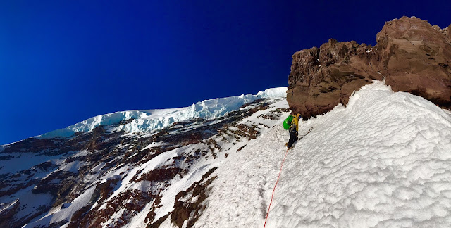
Ranger Waterfall leads out above Thumb Rock. Photo: NPS Reade
Climbing Rangers Reade and Waterfall climbed Liberty Ridge and descended the Emmons-Winthrop in in a 13.5 hour effort from Camp Schurman on June 6.
We left Camp Schurman at 10 PM and descended the Winthrop Glacier to approximately 7400' where we found an old boot track leading to lower Curtis Ridge. From lower Curtis we were able to easily descend to the Carbon glacier on a mix of scree and snow.
The route up the Carbon was very straightforward until 8600' where we encountered extremely large crevasses that forced us to zigzag up and down the glacier looking for bridges to cross the chasms. The bridges that we used may not last more than a few days. Looking down at the glacier from high up on the route however it appeared that there was a better path that traverses to the climbers right at about 8400'.
Once we were able access the bottom of the ridge the route finding was even more difficult. The moats and heavy crevassing forced us to climb onto the bottom of the ridge, traverse right and climb back out onto the Carbon. Then we had to climb the glacier towards Ptarmigan ridge to end run two large crevasses. From there we were able to traverse back left and climb over a small bergschrund to finally begin climbing Liberty Ridge for real.
Once on the ridge we had easy snow climbing until 9700' where we encountered the first of 3 ~fifteen foot rock bands. They each went at 4th to low 5th class on loose rock and we were very happy to climb these at night when the rock was somewhat frozen together. After the third rock band we climbed a few hundred more feet of snow to Thumb Rock.
At Thumb Rock we brewed up some water and relaxed for about 1.5 hours. While we waited for the snow to melt in our stove the sun rose and the wind increased and we observed an increase in rockfall. The majority of the rock rock went to the west side of the ridge but it is notable that the tent sites here are exposed to hazard from above.
We left Thumb and climbed on the east side of the ridge on variable snow and ice. There were large sections with high roackfall hazard as evidenced by lots of rock debris in the snow. We tried to move through those areas as quickly as possible.
Ranger Read climbing above Thumb Rock. Photo: NPS Waterfall
Nearing the top of the Black Pyramid the snow became increasingly more firm and there was exposed alpine ice where the wind had scoured the snow away. We found the climbing here to be increasingly intense on our calf muscles and the ability to climb this type of steep terrain while getting the weight off of our toes was critical to keeping a steady pace.
Ranger Waterfall climbing near the Black Pyramid. Photo: NPS Reade
The slope angle kicks back at 13,000' and we took a short break before heading up into the bergschrund. The bergschrund runs wall-to-wall and we were forced to climb into the ice cap on the climbers left. There we found a large ice system of ice ledges that allowed us to regain the bowl above the 'schrund. From there we climbed steep neve (up to 85 degrees) and finally gained upper Sunset Ridge and easier terrain. From there it was just 10 minutes of easy walking to the top of Liberty Cap.
Ranger Reade climbing into the Liberty Ice Cap. Photo: NPS Waterfall
All told we found the climbing to be engaging and sustained on the slopes above Thumb Rock and definitely worth the effort. However, the condition of the Carbon glacier and the degree of melting on the lower slopes in the next two weeks will possibly make accessing the ridge impossible.


