Mount Rainier Climbing

This blog is maintained by the Climbing Rangers for use by recreational non-guided climbers and skiers. Use these reports as a baseline but plan for changing conditions.

Upper Tab Link Bar

  • Home
  • Weather Resources
  • Avalanche Forecast
  • Permits and Fees
  • Guide Services
  • Support WNPF
  • About Us
  • Contact Us

Wednesday, June 26, 2024

Emmons-Winthrop 6/25/24

 June 25, 2024: Emmons/Winthrop Route 

This blog is maintained by the MRNP Climbing Ranger team for use by recreational non-guided climbers. Use these reports as a baseline, but plan for changing conditions. 

Overview: 

  • Windy! High pressure has dominated the past week with a couple of smaller, upper-level troughs rolling through. With the high pressure centered to the East, this has created pressure gradients that brought strong winds which have turned or kept parties off the route.  
  • Some of these troughs have brought upper-level moisture and formed lenticulars or high elevation cloud decks around 13,000 ft. which created problems for climbers.  
  • Localized white out conditions due to blowing snow has also created problems without clouds developing.  
  • High freezing levels, ~13,000 ft, dropping to around ~10,000 ft. with the cooler storms.  
  • Very warm and Sunny! When there was no storm... 
  • Wet activity has been noted below 11,000 ft. when the strong sun and warm temps developed. There has been wet loose releasing off cliff bands and a few small pockets of wet slab. 
  • The bridges and plugs used to cross, mainly at the 11,400 ft. crevasse, are melting with the warm temps. One crevasse fall was reported this week after a bridge collapsed in the late afternoon. 

The route currently follows the Corridor up out of camp. The first major crevasse crossing is around 11,400 ft, with two options to cross. One option is going straight up over a plug (photo below), or working climbers left crossing a series of crevasses. Both crossings are getting trickier as they melt out. Many are opting to place protection to navigate this section, especially on the descent. The route then continues with several long, right-hand traverses to end run large crevasses, notably at 12,400 ft. and 13,000 ft. The last long right-hand traverse is at 13,400 ft. to end run the bergschrund and get to Liberty saddle. Surface conditions on the route have been great with wonderful cramponing for the majority of the route. There were many successful summits this last week!

Skiers:

The conditions on the upper mountain have made early morning descents in the sastrugi/wind-blown snow tricky. Careful and calculated skiing is required to descend the upper mountain - this is not a beginner ski mountaineering objective! It is worth considering dropping skis and walking trickier sections on the route. There are large open crevasses that would be extremely dangerous in the event of a fall on skis in the wrong spot. Remember to yield to climbers on foot as they have the right of way! Skiing down on top of other mountaineering parties is bad karma.


The 11,400 straight route step


Looking down at the 11,400 crevasse. This shows the climbers left/skiers' right option around the block in the right-hand side of the photo. 

The 12,400 crack which is being end run with a long right-hand traverse at the top of The Corridor


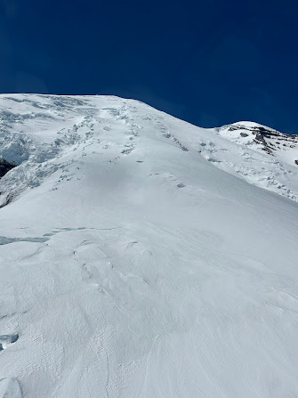
Surface conditions and the bergschrund at 13,600 which is being end run with another long right traverse.


Looking back at the long traverse under the 13,600 bergschrund


The bergschrund traverse ending at the saddle.


Additional Information  

It is strongly recommended that parties rope up to access or descend from Camp Schurman via the lower Emmons. There is a large crevasse complex just below camp that you have to cross. It is opening quickly, and bridges are getting thinner every day.  

Secondly, many parties have been glissading the corridor above Schurman. This is a bad idea. There are crevasses in the corridor that are also growing as we speak.  

Finally... Too many parties are abandoning climbing partners on the upper mountain. NEVER split up. If you are climbing, stay together. If you are skiing, stay close enough to see each other and spot each other. 

Want to generate good camp karma? Use the bear boxes on the side of the ranger hut or burry your food deep in the snow. Ravens and finches have been raiding poorly stored food and can get into your tent. If you show up late to camp Schurman, you will also receive good camp karma by staying quite while you set up. Teams are likely sleeping for their early start, be courteous! Please remember to camp on the Winthrop at least 100’ away from the helicopter pad. 


Posted on Wednesday, June 26, 2024
Email ThisBlogThis!Share to XShare to FacebookShare to Pinterest

Thursday, June 13, 2024

Disappointment Cleaver 6/12/2024

June 12th 2024

This blog is maintained by the MRNP Climbing Ranger team for use by recreational non-guided climbers.

Use these reports as a baseline, but plan for changing conditions.


The last week has brought sunny and seasonably warm weather to the mountain, starting the transition into summer conditions. Snow currently extends to near the Paradise Parking lot but things are melting out quick. Similarly, the Panorama Point approach still takes the winter route, but another few days of warm weather may move the route climber's left to the summer approach. Be prepared for patchy snow up to 7500' on the Camp Muir approach as warm weather continues. 

From Camp Muir, the Cowlitz Glacier crossing remains straightforward, however Cathedral Gap is beginning to melt out and sections of exposed dirt and rock must be crossed in the last couple hundred feet to the top of the gap. Teams should be ready to shorten up rope spacing here where rock is encountered so the rope doesn't knock rock down onto parties below. Currently, the first significant crevasse crossings are encountered at Ingraham Flats, but most are still narrow and/or end runnable. High Crack is beginning to open but is still end runnable to climber's left.  

The traverse from Ingraham Flats onto the lower Disappointment Cleaver

The traverse to the cleaver below the Ice Box and Bowling Alley is becoming more active with the sun and snow melt. It is worth traveling with haste across. Coordinate with other teams passing through this hazardous area to minimize exposure to overhead hazards. A moat has opened up at the base of the Cleaver pushing the route downhill slightly to the lower Backboard access. Fixed lines are established along much of the cleaver, however they should only be used as hand lines and not clipped in to as fall protection. The Disappointment Cleaver itself is about 40% rock 60% snow and changing fast. Teams will once again want to shorten up rope lengths for the cleaver to minimize rockfall. 

The lower backboard entrance to the cleaver. Please do not clip into the fixed lines

The cleaver is starting to melt out and travel on rock more prevalent

Modest snow slopes above the cleaver lead to the high crux of the route, beginning with a steep slope up to 50 degrees at about 12,700', and ending with an airy crevasse step up near 13,200'. There are fixed pickets in these locations that teams may clip their ropes into. Be sure to inspect all fixed protection before trusting them, and leave the pickets/carabiners there for other teams to use. 

Looking up from the top of the Cleaver at the high crux of the current route between 12700 and 13200

The crevasse-step at 13200. Fixed pickets are in place for running protection currently

Above 13,200' the route continues direct to the crater rim with several moderate crevasse crossings. These may widen if warm and sunny weather continues. As teams enter the summit crater, keep watch for moats and fumaroles along the margins of the crater and stay roped up as necessary. It's worth saying again that conditions and the current route track are changing rapidly this time of year. There are several points along the route that a minor change, such as crevasse widening, could significantly alter the route. 

Screenshot of the a route to the summit crater as of 6.12.2024

ttendee panel closed
Posted on Thursday, June 13, 2024
Email ThisBlogThis!Share to XShare to FacebookShare to Pinterest

Emmons-Winthrop Updates 06/13/2024

June 13th, 2024

This blog is maintained by the MRNP Climbing Ranger team for use by recreational non-guided climbers. Use these reports as a baseline, but plan for changing conditions.

Route:

The route is reported in good shape, with little changes from the route outlined in our previous post. Many parties had success climbing this week. There are three notable bridges that were mentioned by many climbers. These are located around 11,500 ft., 12,800 ft., and 13,600 ft. Some parties were able to summit going direct above the Alpine Meadow, but most chose to traverse right at 13,600 ft towards Liberty Saddle.

Photo of the Emmons-Winthrop on 06/09, with the current route outlined in black

Additional Information:

  • Please make sure tents are at minimum 100ft from the Helicopter Landing Zone (LZ). Climbers who are camped any closer to the LZ interfere with rescue operations. Helicopter rotorwash can be up to 60mph within the 100ft radius, causing any loose items and equipment to be blown into the air, and potentially into the helicopter - a huge safety issue. Even outside the 100ft zone, items can blow away. Make sure tents are secured (deadman your stakes/other tent anchors) and that you have no loose items around your camp. Climbers should be camping on snow on the Winthrop glacier side as the first available option. See below the appropriate areas for you to set up your camp.

  • Red: Do not camp here.
    Orange: It's okay...but less preferred than the green.
    Green: Awesome! See the old tent platforms for reference. You can even dig higher upslope than the green bubble. It makes collecting water easy, and you can be more protected from winds.

  • Skiers- please yield to uphill travelers. Climbers on foot always have the right-of-way, on the up and on the down. Skiers become the overhead hazard to anyone below them. Please plan your descent accordingly and be polite to others on the route. 

  • Please rope up for the lower Emmons approach to the prow. There is no difference between this portion of the route, and the route you climb out of camp. The crevasses are the same size and present the same hazard. Photos of the lower Emmons from this week vs. late season 2023 is attached below for reference. 


Lower Emmons early season (above)
Lower Emmons late season


Posted on Thursday, June 13, 2024
Email ThisBlogThis!Share to XShare to FacebookShare to Pinterest

Thursday, June 06, 2024

Emmons- Winthrop Conditions

Pictures from June 1, 2024 

This blog is maintained by the MRNP Climbing Ranger team for use by recreational non-guided climbers. Use these reports as a baseline, but plan for changing conditions.

Photo of Steamboat Prow and Camp Schurman 6/1/24


Overview:

Our generally stormy spring has continued, with windy stormy days interspersed with some periods of nicer weather, where many parties have reached the summit. These pictures are from around 6/1, before the last storm, and with the new snow, these features have been covered in new wind-blown snow, which is now receiving some solar heating. With these conditions, hazards include:

               + Avalanche hazard with the shed cycle
               + Slower travel through variable snow
               + Crevasses thinly concealed by blown snow

View up towards the Corridor from Camp Schurman

Route:

The Emmons-Winthrop route currently runs straight up The Corridor before trending right into the Alpine Meadows Area around 12,600’. There is potential that the terrain above Alpine Meadows could be travelled directly upwards, but it would make for steep travel, and groups have largely been opting to continue the long traverse climbers right onto the Winthrop shoulder before coming back climbers left again to gain the summit. Incoming weather could mean significant changes to the visibility and stability of individual crevasse crossings, reassess them accordingly.

The Corridor - skiers should note that continuing fall-line down the corridor into the Emmons without stopping at camp does require crossing through areas of open crevassing not encountered on the climb up.


Posted on Thursday, June 06, 2024
Email ThisBlogThis!Share to XShare to FacebookShare to Pinterest
Newer Posts Older Posts Home
Subscribe to: Posts (Atom)

In-Depth Route Briefs:

  • Disappointment Cleaver
  • Emmons-Winthrop
  • Kautz Glacier
  • Liberty Ridge

Route Conditions:

  • Disappointment Cleaver (151)
  • Emmons-Winthrop (126)
  • Fuhrer Finger (21)
  • Gibraltar Ledges (6)
  • Kautz Glacier (37)
  • Liberty Ridge (25)
  • Little Tahoma (8)
  • Mowich Face (11)
  • Ptarmigan Ridge (10)
  • Success Cleaver (8)
  • Tahoma Glacier (5)

Web Cams

  • Camp Muir
  • Camp Schurman
  • Paradise
  • Tatoosh
  • More Park Webcams

Blog Archive

  • ▼  2025 (35)
    • September (2)
    • August (6)
    • July (10)
    • June (9)
    • May (5)
    • April (3)
  • ►  2024 (30)
    • September (2)
    • August (5)
    • July (11)
    • June (6)
    • May (5)
    • April (1)
  • ►  2023 (31)
    • September (1)
    • August (6)
    • July (6)
    • June (12)
    • May (5)
    • April (1)
  • ►  2022 (40)
    • September (4)
    • August (9)
    • July (13)
    • June (10)
    • May (3)
    • March (1)
  • ►  2021 (34)
    • October (1)
    • September (2)
    • August (8)
    • July (9)
    • June (8)
    • May (4)
    • April (1)
    • March (1)
  • ►  2020 (23)
    • September (1)
    • August (7)
    • July (10)
    • June (5)
  • ►  2019 (61)
    • September (6)
    • August (13)
    • July (11)
    • June (11)
    • May (14)
    • April (3)
    • March (2)
    • January (1)
  • ►  2018 (79)
    • September (9)
    • August (13)
    • July (16)
    • June (19)
    • May (11)
    • April (4)
    • March (3)
    • February (3)
    • January (1)
  • ►  2017 (99)
    • December (2)
    • November (3)
    • October (2)
    • September (5)
    • August (16)
    • July (26)
    • June (20)
    • May (24)
    • February (1)
  • ►  2016 (23)
    • December (1)
    • November (2)
    • October (1)
    • September (3)
    • August (1)
    • July (2)
    • June (5)
    • May (1)
    • April (2)
    • March (2)
    • February (1)
    • January (2)
  • ►  2015 (8)
    • December (1)
    • November (1)
    • October (2)
    • August (1)
    • July (1)
    • June (1)
    • May (1)
  • ►  2014 (12)
    • August (2)
    • July (3)
    • June (2)
    • May (3)
    • March (1)
    • February (1)
  • ►  2013 (14)
    • September (1)
    • August (3)
    • July (1)
    • June (4)
    • April (3)
    • January (2)
  • ►  2012 (12)
    • November (1)
    • September (1)
    • August (1)
    • July (1)
    • June (1)
    • February (4)
    • January (3)
  • ►  2011 (8)
    • August (2)
    • July (1)
    • June (2)
    • April (1)
    • February (2)
  • ►  2010 (7)
    • November (2)
    • August (2)
    • July (1)
    • May (1)
    • April (1)
  • ►  2009 (4)
    • November (1)
    • May (1)
    • March (2)
  • ►  2008 (7)
    • November (1)
    • October (1)
    • August (2)
    • July (2)
    • May (1)
  • ►  2007 (2)
    • November (1)
    • October (1)
  • ►  2006 (15)
    • October (1)
    • July (1)
    • May (4)
    • April (3)
    • March (1)
    • February (5)
  • ►  2005 (1)
    • October (1)

Search This Blog

Powered by Blogger.