Friday, June 30, 2017

Emmons-Wintrop Update

Little has changed on the east side of the mountain in the past week.  The route remains very direct, and there is an obvious boot pack to follow.  As we transition back to warmer weather this weekend, be cognizant of snow bridges getting soft and weak as you descend in the heat of the day.  The two to watch out for are at the top of the corridor (11,400 ft) and at the end of the traverse through the alpine meadow (about 12,400 ft).

Direct route on the Emmons-Wintrop

Rangers have noticed climbers arriving to Camp Schurman unroped as they cross the Emmons glacier.  Though this short section of glacier may seem benign, it is not.  Huge crevasses criss-cross this section of glacier, and only a few are presently visible.  Traveling unroped on glaciers here requires a solo permit.  Please rope up from the ridge near Camp Curtis all the way into Camp Schurman.
A large, hollow crevasse sits under the climber's trail near Camp Schurman
Finally, remain aware of small crevasses melting out on the Inter glacier as you descend from camp after climbing.  While glissading or skiing, take care to slow down and look over blind roll-overs that may be hiding open crevasses.  Climbers and skiers will find continuous snow above glacier basin. Please take care to stay on the trail as it melts out so you don't crush the fragile flora coming to life after a long winter under the snow.

Rangers enjoy good skiing conditions on the Inter Glacier on 6/28


Disappointment Cleaver June 28, 2017

Congratulating a climber on his 47th consecutive year of Rainier summits.

It is shaping up to be another very busy weekend on the Disappointment Cleaver. We expect a full house at Camp Muir and Ingraham Flats and most campsites are already taken for the weekend.


Ingraham Flats and Disappointment Cleaver -- June 29, 2017

The climbing route remains in good condition from Camp Muir to the summit, thanks to the efforts of the guide services. Little change has occurred to the route in the past few weeks, except for minor re-routes around widening crevasses. 


Disappointment Cleaver track - June 28, 2017

With decreasing snow cover and warming temperatures, rockfall is increasing on Disappointment Cleaver and in the Cathedral Gap area. Helmets are strongly encouraged whenever climbing, but especially so in these areas. Careful footwork and rope management can be helpful in reducing party-inflicted rockfall hazards, so do your part to reduce rockfall risk to climbers below. Yell "ROCK" if you knock down any sizable pieces to alert parties underneath you to warn them.

There are currently no ladders on the route, but there are bountiful fixed pickets and a couple handlines. Whenever using in-situ protection, evaluate it carefully before trusting it. The existing handlines are designed for aiding balance, not catching falls, so avoid clipping or attaching your teams to these as it will create massive bottlenecks that slow climbing teams behind you.

Around 12,700’, there is a threatening serac leaning over the route. This “tsunami” is shedding ice chunks onto the track almost daily. Minimize your exposure to this hazard by moving efficiently and not taking breaks in areas exposed to icefall. The track is quite narrow in this location, which will also make passing other parties difficult.

The "tsunami" above Disappointment Cleaver.
For more information about recent conditions on the D.C., please review the June 25th update.

Thursday, June 29, 2017

Tahoma Glacier Conditions - 6/27/2017

On 6/27, climbing rangers traveled to 10,000 feet on the Tahoma Glacier via the Puyallup Cleaver.  Here is what they saw.


There were only a couple of spots off of Puyallup cleaver that safely accessed the glacier. Rangers chose a snow ramp at 8200' and belayed across the moat.  This ramp was exposed to rockfall and it might be too melted out in another week or two.  There also looked to be a ramp higher up just below lower St. Andrews Rock that could access the glacier.  Your best bet might be taking that approach, as it's pictured in Gauthier's book, but make sure you stay near the Puyallup Glacier side of the Puyallup Cleaver early on as midway up the cleaver itself is impassable due to steep cliffs around 8500'.

Snow ramp leading onto the glacier at 8200'. 

Once on the glacier routefinding was relatively straightforward but included many crevasse crossings. Most of these could be carefully stepped across, though some of them were 2-3 feet wide and quite deep. End running all of these would be challenging as most of these cracks were very long and numerous.


Things started getting more interesting around 9800' feet where rangers were almost unable to find a way through a particularly broken section of the glacier where wide cracks in numerous orientations block passage.  The few bridges in this section were very thin and unsafe.

9800' on the Tahoma Glacier.
Rangers traversed to a compression zone to the south, or lookers right, side of the glacier and found passage to around 10,000' elevation where they witnessed a very large ice avalanche coming off of the ice cap lookers left of the Sickle.

Large ice avalanche near the Sickle. 

Deciding that the only probable route up the glacier traversed under the Sickle runout zone, it was decided to bail and head south to the Success Cleaver which they climbed.

Track log starting when we stepped onto the glacier at 8200' in the upper left and following our traverse to the Tahoma Cleaver.  

The route on the southern part of Tahoma glacier afforded easier travel, and so would be a better ascent route, coming from Glacier Island.  Be advised that at this point, due to a large crevasse spanning almost the entire upper glacier, the only likely route up the upper Tahoma Glacier puts you on the Sickle before traversing back right, which looks like it has been funneling a lot of ice debris lately.  If attempting this route, make sure things are well frozen, start early, move quickly, and realize there is some unavoidable objective danger that must be traveled through.  At this point the Tahoma Glacier route looks like it's best left to early season 2018 and the Sickle route is definitely a no-go.

-686

Muir Snowfield June 29, 2017


Summer is finally coming to the Paradise area and Muir Snowfield. In the past few days, the preferred route to the Muir Snowfield began shifting from the winter trail that ascends Panorama Face to the Skyline Trail.  Pan Face itself is melting quickly. Heavily pocked with boot and glissade tracks, ascents and descents are best suited for those traveling on foot.

Panorama Face - June 29, 2017

Snow is continuous from the parking lot to just above Glacier Vista. There are three short sections of dry trail between there (elevation 6600’) and just below Pebble Creek (elevation 7000’)—stay on designated trails in these areas to avoid damaging fragile alpine vegetation. The bootpack is well established and wanded throughout this area, but as always, be prepared for whiteout navigation in periods of low visibility.


For those hoping to sneak in some summer ski turns, the margins of the Snowfield are still somewhat smooth, especially above 8000’.  Lower elevation areas hold bumpy and sticky snow, especially in the afternoon hours. Please be courteous while skiing and give other visitors plenty of room to reduce the likelihood of collisions.

Tuesday, June 27, 2017

Success Cleaver: June 26, 2017

This trip report is from Jason Griffith of Skagit Mountain Rescue
 
"Current conditions on Success Cleaver:
 
Snow starts below Indian Henry's, it's about 3-4' deep at patrol cabin.  Camped first night on rock slabs below Pyramid Peak ~6.3k, running water all around.   Deep snow most of the way up the Cleaver, good travel generally.


Knife edge portion melted out and can scramble the crest.  Sunday night, stomped out platform at the 10.7k small col on crest of success cleaver.  Left camp at 0230 and found generally good step kicking snow up and right in gullies merging onto Kautz Cleaver ~12.2k (no rockfall, small bits of ice falling on us). 


Above this, we encountered icy sections of snow where we were on front points for long sections (to about 45 degrees).  Second tool helpful since we were moving unroped on the climb to Point Success.  Found weakness to sneak past final cliff below Point Success that only required a short bit of 55 degree snow/ice (~15'). 


We arrived at Point Success around 0700 and wandered across to Columbia Crest.  Quiet morning on the mountain: saw one party topping out on the Emmons, another coming up the Kautz, one entering crater from DC and another ascending the DC as we were descending around 0900. 


The DC itself was amazingly sloppy at 1000, glad to have been down relatively early.  As we approached Ingraham Flats, convection started rapidly building and we watched as lightning hit ridges south of the Tatoosh.  A dramatic backdrop as we arrived at Muir and checked in with Peter! 
 
Rain and wind as we descended the snowfield to Paradise with the summit obscured.  Good timing, I guess."

Camp Schurman Webcam Up!

We just installed a webcam at Camp Schurman today.  Here's the link: https://www.nps.gov/webcams-mora/schurman.jpg

It's just good enough to barely make out the climbers on the route.


Be patient as we work through any unforeseen issues with the system!

Sunday, June 25, 2017

Disappointment Cleaver 6/25/2017

Climbing rangers were able to summit on 6/24 and 6/25.  With the recent warmup, climbing conditions on the upper mountain have improved dramatically.  The guide services put in a lot of work Friday and Saturday resetting the route above the cleaver and there is a nice path all the way to the top.  Thanks to their hard work there are currently few difficulties on the route and it is in fantastic shape for this time of year.

 Ascending toward Ingraham Flats.  The Disappointment Cleaver and the upper mountain are visible.

The cleaver itself is still mostly snow covered, however it's melting rapidly with these warm temperatures.  There are several fixed lines lower on the cleaver. These are installed by the guide services and are meant to be used as hand-lines. There is no need to clip in or prusik in to these lines - this will just slow everyone down.  Feel free to use them for balance, but as with any fixed gear on the mountain, it is prudent to inspect them critically before relying on them. Currently there are no ladders and very few open crevasses that need to be crossed directly.

Fixed lines lower on the Disappointment Cleaver route.  In the background you can see the route crosses under 'the icebox'.  This is a hazardous area as it lies directly below an active icefall.  Move quickly through this area and don't stop!

As the cleaver melts out and more rock is exposed, rock fall will become more of a hazard. Climbing rangers observed many climbers without helmets this weekend.  Helmets should be considered essential gear for a climb of Mt. Rainier and should be donned at Camp Muir for the duration of the climb to the summit. Rock and icefall is a hazard on all Rainier climbing routes. Protect your head!

Track log from 6/25/2017 - DC route.  
Once above the cleaver the route traverses north towards the Emmons shoulder and then makes a long traverse back to the southwest toward the upper Nisqually before cutting up to the crater rim. Midway through the traverse to the Emmons there is a large corniced serac that looms ominously over the route.  Watch out for it and avoid lingering under the overhang - eventually it will collapse.  The route may change soon to avoid this feature, but in the meantime treat it as a hazard and mitigate your exposure.

Rangers wait to descend lower on the cleaver to avoid knocking rocks loose on those below.  As the cleaver melts out, rockfall will increase.  Pay attention to where your team is in relation to others and keep your rope short while on the cleaver.  
As we move into July, the number of climbers attempting the DC will increase substantially. Overcrowding on the route can lead to dangerous bottlenecks and a longer time spent on the route. Teams attempting to climb Rainier will do well to prepare in advance by being in good shape physically and by being dialed in their rope transitions.  Be familiar with techniques to switch from glaciated terrain to moving over rock and adjust your rope intervals accordingly. Dragging your rope through the rock sections of the route is dangerous and bad form.  Shorten your rope while on the cleaver so that it is not touching the ground.

Be patient and communicate with other parties while on the route. Communicating with those around you while at camp may also help to alleviate congestion on the route by staggering the time at which parties start climbing, thereby spacing teams out.  And you might make some friends!


Lastly, the snowfield is currently skiing well, but the snow is quickly disappearing around Pebble Creek and Panorama Point.  Remember to stay on snow or on the trails as the fragile alpine meadows reveal themselves and be careful not to trample on the vegetation.  Respect the rope lines and don't duck under them - they are there to prevent erosion!

Let's all have a safe summer climbing season.

-686

Friday, June 23, 2017

Emmons-Winthrop Route Update

Climbing rangers ascended the Emmons-Winthop route this morning out of Camp Schurman and found a mix of climbing conditions.  Very few climbers have made the summit after the storm cycle that began June 15th.  Winds were high during this period, resulting in very firm conditions on the upper mountain.

The Emmons route has changed little in the last month, though climbing conditions have varied greatly.  Today, rangers found a well defined trail from Camp Schurman to about 12,800 ft.  Above 12,800, the snow becomes very firm and there is no boot pack to follow.  Confident and precise cramponing technique is required for safe climbing and descending this section of the mountain.  Climbers should evaluate their ability objectively, and make decisions as a group about whether they feel confident with the conditions.  The firm, smooth conditions observed today are similar to conditions in the past that resulted in climber injuries and fatalities on this route.  Please be cautious and climb within your ability.

Track Log, Emmons-Winthrop route 6/23/17
With that being said; how does it look for the next few days? Freezing levels are forcasted to increase slightly to 15,000 feet, but the wind remains moderate near the summit at 20-25 mph through Sunday. Winds in the 30's today kept the upper mountain from softening up at all.  We expect this to be the case through the weekend unless the upper mountain winds abate and allow warmer temps to soften the firm snow.

The route from Camp Schurman

This will be a very busy weekend on Mt. Rainier.  The popular high camps are at or near full capacity already (see previous blog post).  Please be courteous to other climbers at camp and on the route.  Congestion will be an issue on the upper mountain, so allow faster parties to pass and be respectful.  Manage your group to minimize time spent in bottlenecks and crevasse crossings.  Enjoy the sunshine and have a fun climb!

Thursday, June 22, 2017

Disappointment Cleaver June 22nd

Ranger hut fully iced over after last weekends storm cleared. Notice all the
wind effected snow in the background.
The past week of weather on Mount Rainier has presented a bit of everything for climbers taking a shot at the upper mountain. 60 mph winds, rapidly rising freezing levels and  2-3 inches of water falling in the form of both snow and rain last weekend have created exciting climbing conditions to say the least. Despite the lull in low pressure the last few days, no guided parties have made the summit in the last 8 days due to insecure upper mountain conditions. High winds, coupled with icy surface conditions above 12,000 ft. have been enough turn around guided groups the last few days. At this time, there is no formal "trail" above roughly 12,500 ft. The guide services have been working tirelessly to shovel in the route but haven't been able to punch it to the top as of yet. That being said, any parties planning to summit need to be fully dialed on their glacial navigation skills, crevasse rescue techniques, route finding abilities and be comfortable sidestepping or front pointing on firm upper mountain snow/ice crusts.

Now that it's been nearly a week since most of the precipitation fell on the upper mountain, it would seem that the snow pack has had time to settle out and consolidate. Despite this, rising freezing levels will undoubtedly increase icefall/rockfall hazard along the route in addition to loose wet avalanches. With so many climbers turning out to enjoy  the high pressure, it will be imperative for groups to move quickly and efficiently through hazard zones on the route. Traversing the Ingraham glacier under the "Ice Box" and the rock gullies on the cleaver itself are repeat offenders. Pictured on the left is a photo taken this week of 17 people parked underneath the rock gullies below the cleaver. With such high temperatures predicted for the weekend, be sure to move quickly through these areas and DO NOT stop below steep snow slopes, ice seracs or rock bands and gullies.

Lastly, crowd management is going to be an issue this weekend with so many parties on route and slow, icy conditions on the mountain. Handlines are meant to be used as handlines and teams should not attach any devices or prussiks to these lines along the route. Running protection is in place along a few of the steeper sections along the route and should be used efficiently if needed at all. This may not be the weekend to climb Mt. Rainier if all members of your party aren't comfortable with rope management skills and using running protection. Ensuring your team is comfortable in possibly icy conditions will help prevent bottle necks and keep climbers moving safely up/down the route.

Tuesday, June 20, 2017

Climbing Conditions on the Emmons/Winthrop and The Inter Glacier (6/19)


Glacier Basin, looking towards St. Elmo's Pass
Starting out from the White River Campground, expect to be walking on dirt for about two miles or so, but still a fair amount of snow in Glacier Basin.  With all the warm weather, be super cautious about traveling on snow over rivers and streams.  If you can hear water running below, assume its a fairly thin bridge that may or may not support your weight, and think about an alternate route.  This is especially true right out of Glacier Basin crossing the Inter Fork of the White River.


Crevasses on the Inter Glacier are beginning to open up so keep an eye out for them on your way up and down.  The traverse/descent from Camp Curtis to the Emmons still has a fair amount of snow, just keep an eye out crevasses once on the Emmons Glacier and make sure to rope up.

Wet Slab release on the Winthrop Glacier
We spotted quite a few point releases in steeper terrain above Camp Schurman.  Mainly new storm snow that was just beginning to see the sun.  Keep an eye out for these wet/loose avalanches.  Though they are small, they pack a lot of energy, and have the potential to carry you through consequential terrain.  We did spot a small wet slab avalanche on the Winthrop Glacier around the elevation of Camp Schurman, so the potential for wet slab activity exists, especially with the warm temps and recent new snow.  Remember, the best indication that there is potential for avalanches in the area is if you see recent signs of natural activity.

View of the route from Steamboat Prow
Track of current route
Currently, the route heads up from Camp Schurman and past the Emmons Flats and climbs the Football Field for a couple hundred feet.  Be sure not to cut over to the Corridor too early, otherwise you will be forced to navigate through an area where very thin bridges are present.  Once on the Corridor, ascend up to the Alpine Meadows and begin a mellow ascending traverse towards the Winthrop shoulder.  You can then keep a fairly direct line up to Columbia Crest.  Traversing the shrund to Liberty Saddle is unnecessary at this point in time and adds time to your ascent as well as puts you in a zone with more objective hazard
than you would be in otherwise.


Looking up the Inter Glacier towards
Steamboat Prow

Friday, June 16, 2017

Cam Muir/Muir Snowfield June 16th


Ranger hut before the storm picked up in the night. Current weather conditions aren't allowing for great photo's.

With 2.5 inches of water falling from the ski in the last 24 hrs, and sustained winds above 35 mph this week's storm has proven to be much more than a summer squall. Since the storm began early Thursday morning, visibility at Camp Muir has been nearly zero due to the sustained winds, intense precip and high level of snow transport. All independent climbers and guided teams turned around near pebble creek or below yesterday due to deteriorating conditions. Although the weather is forecast to let up a bit by Saturday, sustained winds and another pulse of precipitation on Saturday evening may continue to make mountain travel difficult through the weekend. Although the winds are making it tricky to judge the total accumulation of snowfall on the upper mountain, it's certainly stacking up on leeward aspects and "fetch" zones. Rangers are experiencing pockets of snow around camp from 1-3' in depth. Everything else around camp that hasn't accumulated new snow is covered in 1-3" of ice. 

Guided parties headed up to Camp Muir today are reporting challenging conditions in the white out and difficult navigation as many of the wands up the snowfield have either blown away or are buried in snow. In storms like this, proper preparedness and conservative decision making are more crucial. What starts out as light rain leaving the parking lot can quickly turn into blizzard like conditions as temperatures drop and saturated clothing begins to freeze. Anyone planning to travel up the snowfield this weekend should be carrying a GPS with an appropriate track log or "route" of the path to Camp Muir. Appropriate winter layers/clothing and enough supplies/equipment to make an emergency bivy on the route if necessary are also critical this weekend. 

Many folks have been calling to inquire about climbing conditions as the weather breaks and begins to warm early next week. Although the weather is calling for general clearing by next week, climbers must keep in mind the amount of new snow this storm cycle has put down on the mountain (2.5 inches of water!!!!) in the last 24 hrs. This, paired with the rapid warm up will no doubt lead to unstable snow conditions on the upper mountain for a few days as the snow pack begins to heal/consolidate. If you plan to come up for a climb or an overnight in the next few days, be certain to tie in with rangers stationed at the Climbing Information Center in Paradise. These rangers are and invaluable resource for weather and route condition information before you head up the hill. 

Disappointment Cleaver Conditions

Track Log from 6/10
Climbers have been having fairly high success rates via this route despite the winter-like weather.  A well wanded and kicked-in route exists.  Snow still covers almost all of the Disappointment Cleaver and Cathedral Gap which makes for safe and efficient travel with crampons on.  There are a couple of hand-lines in place that the guide services maintain.  These are exactly what they're called - hand-lines.   Don't try to clamp on an ascender and aid-climb up these ropes. 
Photo of the Disappointment Cleaver

A larger crevasse at 13,900 feet has a thinning snow bridge and a steep slope above it.  This makes for a hazardous situation when the first climber makes it across the crevasse safely and the rest of the climbers still have yet to cross.  If the snow bridge were to break underneath the second climber, they would surely drag the first climber on the steep slope above them.  There's different techniques to make this situation safer for both climbers - either using running protection or setting up a quick belay system.  As we approach "prime-time" on the mountain, please be respectful of the Leave-No-Trace guidelines so everyone can enjoy this amazing place! 

Thursday, June 15, 2017

Liberty Ridge, June 16-June 18

Liberty Ridge climbers! 

- And all of you folks out there considering any of the other routes on Mt. Rainier this weekend.  I will attempt here to help give you more good information about attempting a climb this weekend.

* Yes!  There is a bit more snow at 10K and 12K feet this year than normal.  This has made climbing conditions great, especially on the non-standard routes, and also for skiers.

* Yes!  This is the right time of year to be thinking about a climb of Liberty Ridge.

* Yes!  The route goes right now.

HOWEVER!!

* No.  This is not shaping up to be a good weekend to attempt climbing Liberty Ridge.

Here is the issue with Liberty Ridge

The route with the highest rescue rate on Mt. Rainier is Liberty Ridge.  You have somewhere between a 2-5% chance of being involved in a rescue on this route, depending on how you spin the statistics.  We haven't done this, but if you were to analyze the statistics of Liberty Ridge climbers who attempt to climb the route in marginal weather, the % rescue rate, I'm guessing, would be far higher.

In post-incident interviews with rescued parties, they are often quoted as saying, "Up was down," meaning that you can't down climb the route.  So escape from the route only tends to put climbers in even more peril as they ascend into worsening, colder, and windier conditions.

What can we do about this?

You need a good, solid, reliable window of obviously good weather before leaving Thumb Rock.  What is good, solid, and reliable?  Most parties take LONGER than they think to climb from Thumb Rock and return safely to Camp Schurman.  Factor this in.

With knowledge of an increased exposure to rescue, underestimating the route, we're saying give yourself at least an 18-24 hour window where there is an obvious, incontrovertable good weather forecast.

What are we looking at this weekend?

Hmm..  Not good.  Not obvious.  Not incontrovertable.

Where do we start?

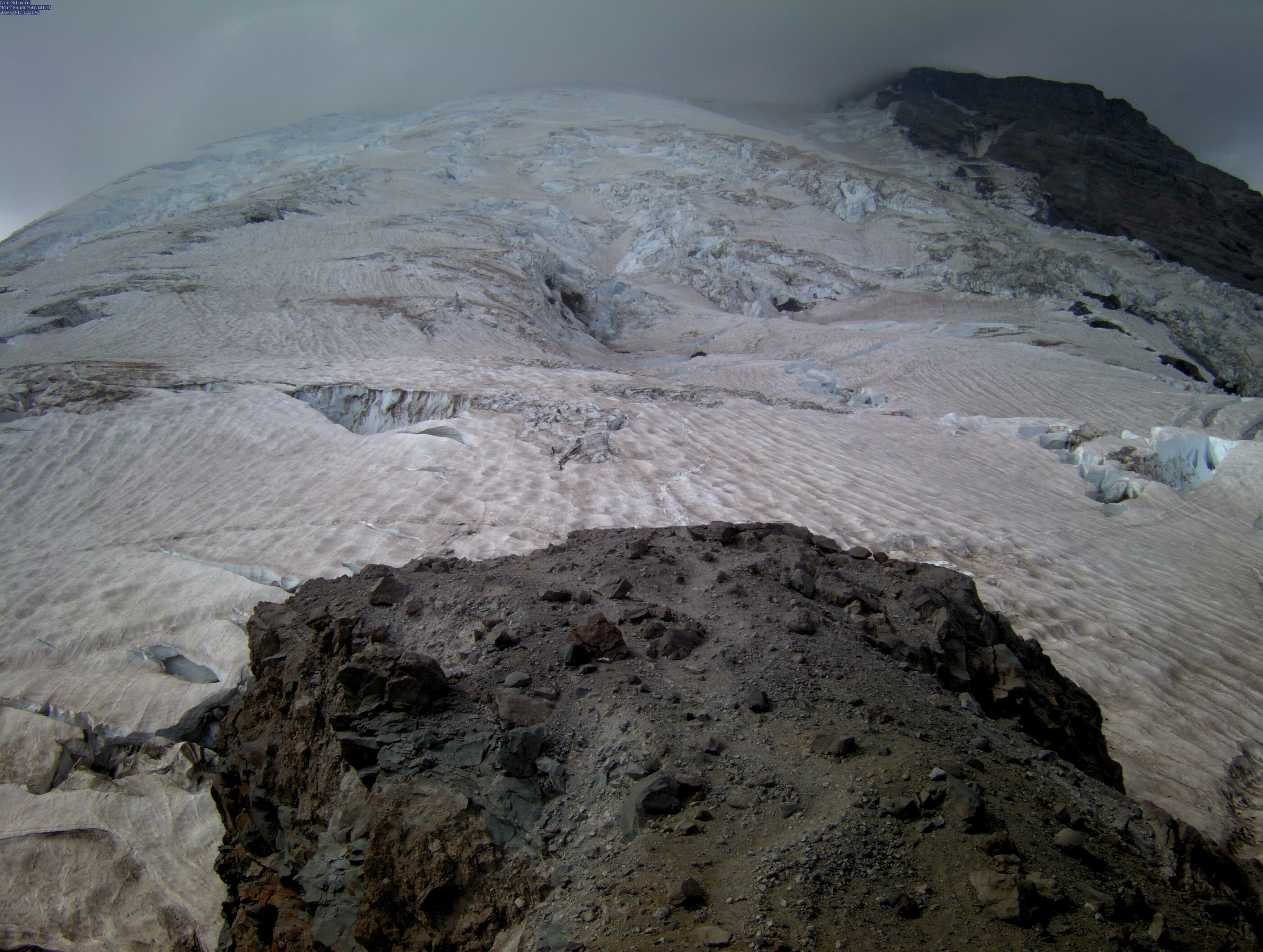
Let's look at the Meteogram for Paradise:


And then let's cross-reference this with the UW MM5 Mt. Rainier Cross-Section for Thursday night:


So it's gunna dump big.  Lot's of precipitation Thursday and into Friday.  And it appears to be along the full elevational profile of the mountain.  Expect new and drifted snow.  There's quite a bit of wind associated with this weather system, too, so the snow will drift.

By 08:00 am on Saturday, the storm backs off, but another approaches on the horizon and comes in with moist air up high.  Check out the image below and pay attention to the upper moisture coming in up high.


By midnight on Saturday and into Sunday, this is what we're dealing with:


As you can see, once again we're getting blessed with more weather up high.

So what's the bottom line:

* This is not a good time to plan to climb a route like Liberty Ridge.  There is not a good clear period (18-24 hours) of good, promising weather.

Friday, June 09, 2017

Inter Glacier June 9, 2017

June-uary conditions have arrived on Mount Rainier. The past 48 hours has brought new snow to the mountain, with a trace of new snow as low as 4800' and accumulation beginning around 5800'. Snowfall totals are in the 1-4" range between 5800' and 9600'. 


The Glacier Basin Trail is largely snow-free until 5400'. At 5400', however, the approach to Glacier Basin changes dramatically. There is a short (100 yards long), but significant section of avalanche debris filled with snapped trees and branches. This section is wanded and has a decent bootpack, but it is strenuous travel and adds a few minutes to the journey into Glacier Basin. Beyond this blowdown, there is continuous snow all the way to Camp Curtis. 
The Inter Glacier is completely filled in, except for one small crevasse that is starting to open around 8000' on the climber's left side of the glacier. Recent snowfall has somewhat smoothed the surface conditions, with 1-3" of new snow lying over last week's corn snow. This snow has already begun the transformation into spring snow, so early June powder skiing conditions were short lived. Beware of this new snow warming up on solar slopes and with rising freezing levels since loose wet avalanches are possible. 

Travel conditions this weekend are expected to be challenging with shin-deep boot penetration and whiteout conditions. Personal experience, competence in GPS navigation, and conservative decision-making are essential with the current weather and snowpack conditions.

There is no established bootback on the Emmons Glacier and teams should not expect and wanded or maintained route. Travel and navigation on the upper mountain will require a full complement of glacier travel and mountaineering skills this weekend.

Little Tahoma June 8th, 2017

Summit ridge
       Climbing rangers were able to get out of Camp Muir on Wednesday before the incoming low pressure to check out route conditions on Little T. Fortunately, the weather held and it made for a pleasant day of climbing to the summit and back. The plan was to drop from Camp Muir down the Cowlitz Glacier, across the Ingraham, up the Whitman and onto the SE ridge of Little T. 

       As we had hoped, dropping down the Cowlitz was fairly straight forward. Parties can avoid the vast majority of cracks by hugging the east side of the glacier as you descend roughly 1,600 ft. A mellow ridge crossing will get you onto the Ingraham Glacier at 8,600'. Try to maintain elevation as you contour across the Ingraham. There are many tight, parallel crevasses here so careful route finding is essential. Once across the Ingraham Glacier, a large snow ramp will allow you to gain the ridgeline that separates the Whitman from the Ingraham. Currently, the rock step exiting the snow ramp necessitates 8 ft. of climbing before leading to easier scrambling. As things continue to melt out, this step will undoubtedly become higher and the presence of a moat may create issues. 

Hogsback/rock band as you exit the Ingraham onto the Whitman.
            Route finding up the Whitman is fairly straight forward as this glacier is not so broken as the others. 400' of climbing will place you onto a large bench at the base of the SE face of Little T. This offers a good view of the rest of your climb. Two large cracks on the west side of the upper Whitman will push you to the climbers right as you ascend.  It is worth noting that the upper pitches of the snow here (9,800-10,800 ft.) are quite sun cupped and not ideal for skiing.

Looking up at Little T from the approach on the Whitman. Notice the two cracks on the upper left of the photo.
          Near the top of the Whitman, there is an obvious exit gully on the climbers left just below 10,800 ft. Although the climbing through the gully is not super strenuous, the amount of loose blocks may warrant protecting this section with ropes and gear. There is a slung horn at the top of the gully that can be used for belaying your second and/or lowering/rappelling on the way down. Always be sure to inspect the integrity of permanent anchors before using them.

4th class scramble off of the Whitman glacier and onto the SE ridge
Maneuvering through another small snow patch and up a short section of 3rd class rock will get you to the summit ridge. An exposed/airy traverse allows a great opportunity for a pitch or two of climbing. The rock can be quite rotten in this section so a few slung horns and careful hold selection is most helpful. Be sure to place gear for your follower here as a pendulum fall could be nasty. Enjoy the views down onto the Emmons and back east to White River. Descend the route, ensuring proper belays/lowers/rappels are utilized based on your teams personal comfort level.

Track log from Camp Muir to Little T summit
             Climbing the 3rd tallest peak in the state is a worth while outing and offers an excellent opportunity to test your skills on both glacier and rock. If you are looking for a climb with a bit more solitude and variety compared to the DC or the Emmons, Little Tahoma might be worth your time. Keep in mind that route conditions are bound to change as summer progresses and things continue to melt out. Safe climbing!