Thursday, September 26, 2019

Disappointment Cleaver Final Update for 2019

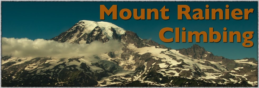
Clouds surround the summit as a storm rolls in. September 25, 2019.
Fall is upon us at Mount Rainier and that means winter-like conditions on the upper mountain. There has been significant snow on the mountain in the last two weeks and we are expecting more in the next few days.

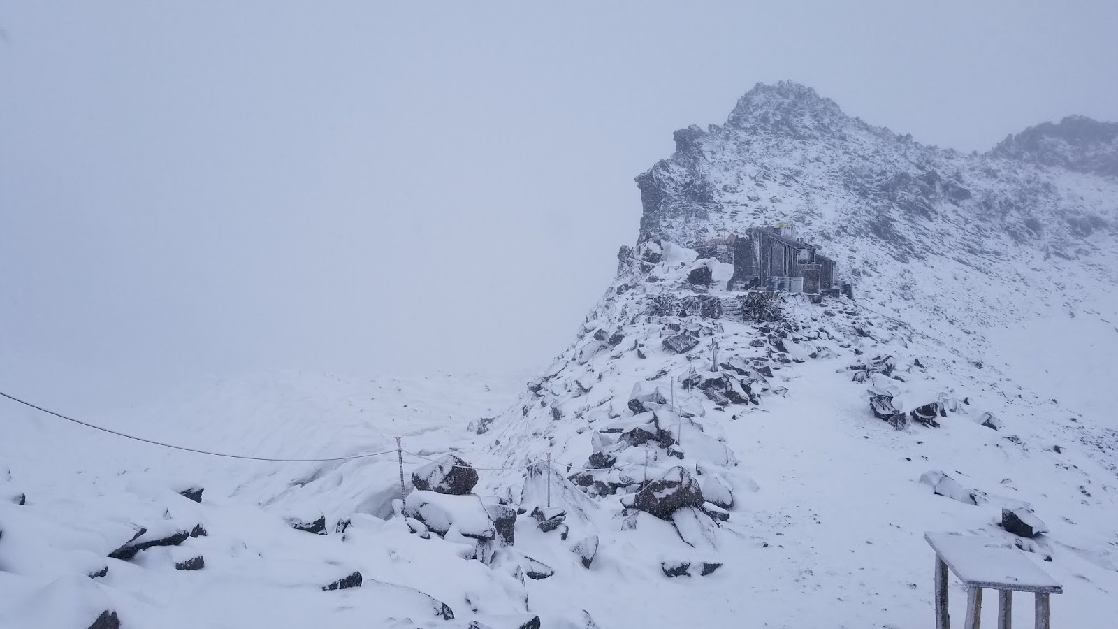
This creates a particularly hazardous condition where the crevasses are as open as they ever get, but are now thinly covered with a veneer of new snow. We have had several parties experience crevasse falls in the last few weeks, thankfully with no injuries.

Icy, steep serac walls and newly formed wind slabs are other hazards that climbers will encounter this time of year. That's along with the usual rockfall, icefall, and altitude hazards that occur year-round. 

Now that snow has returned to the mountain, ski conditions are starting to improve, but skiers/boarders still have to hike 2000 feet up AND down since the snow doesn't start until above Panorama Point.  Due to thinly covered crevasses use extreme caution when skiing the snowfield between 8,500' and 9,500' and if you're venturing onto the Paradise Glacier. There was a remarkable turnout considering the variable conditions of skiers and hikers this past Saturday.  Don't ruin this winter season by getting injured in poor/rocky conditions this fall. 

When traveling to Camp Muir this time of year, be prepared for Winter weather! The Muir Snowfield is statistically more dangerous than a climb to the summit, with the majority of major incidents and fatalities occurring because of poor weather, lack of preparation, disorientation, and exposure.  

Guide services will continue to run summit trips through the first few days of October. After that the upper mountain will be cleaned of wands and route adjuncts. If you're planning a summit attempt between then and early May plan on being totally self-sufficient.

Seasonal climbing rangers are off duty for the season and while there is a skeleton crew of climbing rangers through most of the winter, high camps are not staffed regularly and any response to an injury or incident will take hours, even days. 

The Self-Registration Kiosk for Climbers can be found just inside the entrance of the Guide House
The Paradise Wilderness Information Center is also closed for the season. Climbers can still self-register at Paradise using the self-registration kiosk (currently located in the hallway of the Guide House) or register in-person at the Longmire Museum.

The Climbing Fee and Registration are mandatory for all climbers/skiers venturing on glaciers or above 10,000'
If you're reading this blog while planning a climbing trip to Mount Rainier next season follow these links to view our in-depth route briefs on the Disappointment Cleaver Route, the Emmons-Winthrop Glacier Route, the Kautz Glacier Route, and Liberty Ridge.  

Thanks for a great summer season and see you next year!

End of Season at Camp Schurman


Camp Schurman from Steamboat Prow

Climbing Ranger operations have come to their end at Camp Schurman for 2019. Visitation has been next to zero for the past few weeks. Access up the Inter glacier remains challenging, and the Emmons is very broken in its late season condition.


Rangers and park staff have been busy no the less, taking advantage of a quiet camp to work on a new helicopter landing zone and repairs to the Ranger Station.

New Helicopter Landing Pad


If you do chose to take and adventure and travel to Camp Schurman this Fall be aware that there are no open toilet facilities, but a Blue Bag barrel does remain available. You may have to clear off a bit of snow to find it.

Climbing and Wilderness permits are still required thru the Fall for travel on Mount Rainier above 10000 ft and on its Glaciers. These can still be acquired at the White River Ranger Station thru mid October.


Camp Schurman

Have a great Fall and Winter Season and we look forward to seeing you back at Mount Rainier and Camp Schurman in 2020.

Sunday, September 15, 2019

Camp Muir 09/09/2019


New snow at Camp Muir

Camp Muir has received a few inches of new snow in the past two days. In fact, a dusting of snow fell as low as Pebble Creek on Monday! While it’s not enough to smooth out the snowfield for skiing, it is enough to thinly cover open crevasses and make them difficult to identify. There are a few such holes between 9,500’ and 8,800’ that are certainly large enough to fall into. These are especially difficult to see in flat light or whiteout conditions.

Fresh snow starting to obscure crevasses on the snowfield

As the summer season winds down, so does the amount of traffic on the Muir Snowfield. Expect the trail to become less obvious (or totally obscured by new snow) and to see fewer people out and about. Travel conditions above Pebble Creek have become quite firm and additional traction is recommended—many people are opting for crampons. Be prepared to do all of your own navigation and decision-making. Carry and know how to use a GPS, since it is very easy to get lost on the snowfield in whiteout conditions.

Whiteout conditions below Camp Muir

Be sure to check the weather forecast and park webcams before your visit, since conditions change rapidly this time of year.

Friday, September 06, 2019

Emmons Winthrop End of Season 09/05/2019


View of Glacier Basin September 2019

As summer winds down, so does the climbing season on Mount Rainier. No parties have attempted the Emmons Glacier route recently. Climbing Rangers have finished doing patrols of the route for the year, and all guided climbs have ceased. Although it is probably still possible to forge a route above Camp Schurman, all parties attempting such a late-season attempt should expect a very long day and circuitous, complex navigation requiring honed glacier travel and ice climbing skills.

Beware that autumn storms often deposit enough snow to obscure any remnant of this summer's climbing route and can thinly cover open crevasses. Serac fall has also been observed recently. Be prepared to do all of your own navigation, route-finding, and decision-making if you choose to attempt the mountain this late in the season.

This will be the final update for the Emmons Glacier route for the 2019 climbing season. If you're planning a climbing trip to Mount Rainier next season and are doing some pre-trip planning follow these links to view our in-depth route briefs on the Disappointment Cleaver Route, the Emmons-Winthrop Glacier Route, the Kautz Glacier Route, and Liberty Ridge.

Thanks for a great summer season!  Happy Autumnal Equinox and see you next year!

Thursday, September 05, 2019

Muir Snowfield Update 9/4

As we transition into September, the Muir Snowfield is becoming more of an "Icefield" than a snowfield.  The majority of the hike beyond Pebble Creek has exposed glacial ice with a number of open crevasses above 8500'.  Where there is snow, the surface conditions are quite sun cupped and capped with a fine layer of rock and dust.

The crevasses that are present on the upper portion of the snowfield are easy to spot and navigate around, but caution should still be taken as the surface condition adjacent to these features are firm and icy.  Take caution while descending from Camp Muir, as a couple of these cracks can be difficult to spot from above.


While navigating the Muir Snowfield, we recommend bringing sturdy footwear that are capable of accepting micro-spikes or crampons which will greatly aid in security.  Trekking poles are also very useful!


Water is present around the lower rock outcroppings as well as on the top of Moon Rocks.  Beware though, as the Muir Snowfield sees a large amount of traffic and filtering the run-off is highly recommended.

Safe Climbing!

Tuesday, September 03, 2019

Trash & Waste + Route Update

September vistas of Camp Muir
Rangers have been experiencing an uptick of trash and human waste left on the Disappointment Cleaver Route.  We ask you to please pack down what you bring up.  Understandably, it can be difficult to maintain wrappers and micro trash, but please do your best to keep a handle of these items.  These unsightly attractions detract from the climbing experience for all visitors.  Please do your part and leave mountain in better condition than how you found it!

While on patrols of the DC, rangers have noted more human waste directly off the boot pack.  The Paradise Wilderness Information Center (PWIC) offers blue bags free of charge to climbers.  Please be responsible and use these blue bags to collect and carry off your waste, otherwise, others will have to do this.

We have also found a number of soiled blue-bags left both at Ingraham Flats as well as along the route.  Not only are these climbers not doing their part in removing their human waste, they are now littering and leaving plastic in a delicate alpine environment.  Please, if you go through the effort to use a blue-bag, do your part and dispose of it into a designated blue-bag barrel at Camp Muir.

Human waste, blue-bags and trash left along the route
     
       _____________________________________________________________________

The DC route is largely unchanged since the last blog post update. When approaching rock features along the route, use cation and be on the lookout for hollow moats and ablated glacier ice.

There is still only one ladder on the route, currently located at 13,100'.  This is configured in a vertical orientation.

As we make our way into September, climbing tactics have to adapt to the changing conditions.  Be aware of more rock and ice fall.  A fair amount of the route has ablated glacier ice present as well as firmer snow conditions.  Come prepared with the appropriate climbing equipment such as crevasse rescue equipment, ice screws and pickets than can be easily be placed from a self-arrest position.

Safe Climbing!

Unstable boulders perched on ablated glacier ice, viewed from Cathedral Gap, looking towards the Ingraham Glacier
Looking towards the base of the Disappointment Cleaver from High Crack

The Bowling Alley from the
Disappointment Cleaver over to the Ingraham Glacier
Top of the cleaver, looking at the Upper Mountain
Climbers descending the ladder

Climbers descending the upper mountain, just above the top of the cleaver


Current track as of September 2nd, 2019

Friday, August 30, 2019

Emmons/Winthrop and Camp Schurman Update 8/29/19

Camp Schurman and Steamboat Prow from the Corridor. 

Climbing season on Mount Rainier's east side is winding down. Camp Schurman was a good spot for alpine solitude this week with only a handful of parties attempting to climb. Rangers waited out the high winds last weekend until Sunday afternoon to climb and explore the lower part of the route. Rangers climbed to 11,000 feet on the Corridor, and negotiated most of the route difficulties before turning around. September climbing on the Emmons/Winthrop requires a slightly different set of gear than early season. Bring ice screws, pickets, and sharp crampons along if attempting to climb. A shovel is a good idea as well so your party can chisel out a tent platform on the snow at Camp Schurman.

Getting to Camp Schurman
The Inter Glacier is crevassed and firm, with lots of exposed ice. Parties will need to don crampons and rope up for the Inter Glacier. An alternate route up Mount Ruth to Camp Curtis exists, but check with the rangers at White River for more information about traveling this way. From Camp Curtis, travel to the upper sites (#3,4,5) to find the climber's trail descending through the scree towards the Emmons. Parties have reported encountering difficulties getting across the moat onto the Emmons Glacier.

Camp Schurman to Emmons Flats
From the edge of the Prow above the helipad, the route climbs directly up through a maze of crevasses and exposed glacial ice. Variations further climber's right look more appealing, but dead end in large, open crevasses. Expect to belay your partners from pickets or screws over a crevasse or two in this section, as some crossings are pretty wide and arresting a fall would be otherwise impossible on the firm glacial ice here.

Looking up at the route from Emmons Flats. The Corridor is illuminated by sunlight on the left.

Emmons Flats to the Corridor
From Emmons Flats, climb straight up though sun cups trending toward the bottom of the Corridor. Parties will encounter a set of large crevasses running horizontally that funnel into one remaining snow bridge allowing passage onto the Corridor. This bridge is narrow, but still well supported on the uphill side with snow. Inspect this bridge before crossing it, and belay your team across if necessary.

Corridor
The Corridor has firm snow, and sections of glacial ice. The travel is arduous and not exactly straightforward. Stay mostly climber's right as you ascend the Corridor. Countless crevasses cut through the route here, running in all directions. In several spots, the only way to build an anchor in the event of a crevasse fall is with ice screws. The route finding becomes more obvious as you approach the top of the Corridor.

Top of Corridor to Summit
Few parties have ascended above the Corridor in the last couple weeks. The best information about this section of the route can be found in the last Emmons blog post. The upper part of the route has more snow still, but don't expect easy travel to the summit. Climbing to the summit will make for a very long day. Be prepared with plenty of food, water, and anchor materials. As always, take a GPS track on the ascent to give your team something to follow on the way down.

Thursday, August 29, 2019

Muir Snowfield Conditions Update 8/28/2019

Beautiful summer weather finally arrived at Mount Rainier National Park and the days have been nice for hiking on the mountain. That said, walking conditions on the Muir Snowfield continue to deteriorate as the summer season progresses.

Crevasses are beginning to open up above 8500' and icy patches are melting out all over. The guide services have made the switch to crampons for their trips up and down the snowfield. Skilled snow walkers may be able to navigate the firm patches but we definitely recommend micro-spikes or full crampons.

A crevasse on the Muir Snowfield
We still have the odd (no pun intended) skier or two making the journey to Camp Muir and trying their luck at skiing back down. We definitely cannot recommend that due to the conditions however. The surface is a mix of the aforementioned ice with pumice and plenty of loose rock all around. Please use extreme caution when skiing as the open crevasses can be very hard to spot due to the roughness of the snow surface.

The view down to Paradise from 10,000'
As September approaches we will see a return to stormy weather. If you're planning a trip up to Camp Muir or beyond please prepare for the trip by checking the weather and bringing the essentials, especially navigation equipment.

Disappointment Cleaver Update 8/26/2019

As of 8/26, the Disappointment Cleaver route is unchanged from the previous post. The guide services are still running trips on the DC, but independent climber numbers are decreasing precipitously.  Camp Muir is nice and quiet on weekdays.  The route is still climbing well for this time of year.  The late-season nature of conditions make it slightly more challenging than a July ascent, but many climbers are having successful summit climbs.  Come enjoy a quieter experience on the DC!

Looking up from Ingraham Flats.

The ladder around 13,000'.  There are fixed ropes above the ladder to aid in ascent. 

Thursday, August 22, 2019

Disappointment Cleaver Update 8/21/19


Morning sunrise above Little Tahoma from the Disappointment Cleaver

 Largely unchanged since the last route update on 08/16/19, the Disappointment Cleaver route continues to climb well even as crowds begin to die down on the upper mountain. Compared to recent years, climbing conditions along the DC remain quite nice with diminishing traffic, minimal to non existent smoke and a fairly direct route to the summit. Although the long term forecast calls for high pressure and warm temps, we are already beginning to see the first signs of late season weather. A brief, yet intense storm blew in earlier this week, dropping freezing levels nearly 6,000 ft. and driving rain, whiteout and 60mph winds across the mountain.

Evidence of large icefall and objective hazard in the Icebox above Ingraham Flats.
To echo the previous posting, rockfall and icefall continue to be the main hazards along the route. Group management, appropriate rest locations and efficient travel through hazardous zones are our best tools for managing the hazards that we can't totally mitigate or avoid. Once onto the spine of the cleaver itself, teams should remember to manage their ropes so as to not be travelling in glacier mode while on rock. There are many ways to manage your ropes through rocky terrain so try to come prepared or feel free to ask a climbing ranger while in camp.
Upper mountain looking from the top of the Disappointment Cleaver. If you look carefully, you'll notice the bottle neck of climbers around the ladder at 13,000'.
 With the busiest weekends of the year behind us, crowds and bottlenecks are becoming much more manageable. Although there is only one ladder on the route, brief delays are still a reality as teams try to manage the obstacle. From the top of the cleaver, you can look up and right roughly 600 ft. to assess how many teams might be stacked up or negotiating the ladder. The guide services are efficient in their travel but they do climb in groups of 12. Providing for appropriate spacing along the route can help to ease congestion for everyone.

Vertical ladder located approximately 13,000'. Many teams have been opting to backup their team via a quick belay on the way back down the ladder. 
Despite being fairly unexposed, the nature of climbing a ladder at 13,000 ft. with crampons, heavy packs and tired legs makes it easy to understand why some groups take some time getting through. There remain two fixed lines to either side of the ladder as well as mulitiple lines to secure it in place. Teams should consider backing up their partners for the descent via a quick belay or backup on one of the fixed line. These are skills your group should know ahead of time or practice while in camp rather than on-sighting in the field.
Photo of the current route, largely unchanged from the last post on 8/16/19
With a brief lull in the weather over the upcoming weekend, climbing conditions look promising into the last week of August. Moving ahead into September, climbers can expect to find nice conditions for climbing the DC but should ensure that they come prepared for the weather to take a turn. Contingency equipment such as a stove, gps, bivy/tent, sleeping bag and pad are critical items that can make the difference if caught off guard by weather.

Wednesday, August 21, 2019

Variation to Emmons Climbing Route


Crevasse at 13,000'
Rangers from Camp Schurman proofed a variation on the standard climbing route on Sunday. As the glaciers open up more and the route changes adding more distance to the climb, this new route takes a more direct approach up the Emmons Glacier.
Variation to route up the Emmons Glacier
Leaving from Camp Schurman the route negotiates a heavily crevassed section of glacier until you reach Emmons Flats. The crevasses in this area are traditional to the route this late in the season and are mainly composed of skeletal ice.
Looking down at Camp Schurman from atop Steamboat Prow


Crossing the Emmons Flats and lower "football field" is mostly sun-cupped soft snow. Several large snow bridged cravasses at the base of the corridor are well supported and easily crossed. Take a look under the snow bridge to see what is supporting it. If it seems questionable then look for other options.


From the top of the corridor, approx 11,000’ the route can be climbed out to the right, following the standard summer line of ascent, or out to the climber's left into the upper Emmons Bowl. This upper bowl holds large deposits of winter snow making it challenging uphill travel early season. The large expanse of smooth snow is a great option for late season when the snow pack is consolidated and boot penetration is minimal.

Route finding through the upper Emmons Bowl to 13,000’ is relatively easy with the majority of the landscape visible. Taking a low approach (climber's left side of the bowl) will offer some distance from seracs and occasional ice fall that releases on the right side the bowl. The left hand side will also give a more direct ascent line to end run large crevasses extending across the slopes.

At the 13,000’ elevation there is a large vertical fin of snow that marks the top end of the bowl.  This also marks the beginning of the route finding. The landscape above is hidden from view, but with every new crest additional large expanses of smooth terrain will appear.

Climb right of the fin at 13,000' to end run two parallel crevasses. From this point the route trends left, but doesn’t meet up with the Disappointment Cleaver Route - not that far left! Climbers will find small snow bridges where the seemingly impossible crevasses narrow down to the point where small snow bridges provide passage.
New route
If you're looking for adventure on Mount Rainier and want something new, then try a late season Emmons Climb. This route doesn’t disappoint! 

Friday, August 16, 2019

Emmons-Winthrop Route Update 8/15/19

Little Tahoma and the lower Emmons Glacier

Camp Schurman was relatively quiet this week despite several days of great weather. The route to the top is still climbing well, and climbers can expect an exciting and engaging climb above camp. The Inter Glacier has several crevasses, so roping up is recommended here. Check out this previous post for great beta on the approach to Camp Schurman.

The Inter Glacier has crevasses and exposed ice in spots. Glissading is not recommended.
The snow on the lower half of the route is quite firm and a little icy in spots, so rangers recommend that each party bring a couple of ice screws for running protection or anchors. The upper half of the route still has plenty of snow, and pickets are essential equipment for building anchors on the upper mountain. Make sure your climbing team has both pickets and ice screws for your climb.

A rough representation of the Emmons-Winthrop climbing route.
From Camp Schurman, the section of glacier leading to Emmons Flats is quite broken. The boot pack still takes a good line through here, but expect to meander a bit around crevasses. Above Emmons Flats, the track wastes no time climbing to the Corridor. Getting onto the Corridor, climbers will cross a large crevasses that is spanned by a long, narrow snow bridge. Give this bridge a look before crossing it. Rangers found another snow bridge about 100 feet higher that works as well.

Once on the Corridor, climbers will find firm snow and a boot pack that winds up along sun cups. There are numerous crevasses cutting through the Corridor, so be on your game and pay attention. Evaluate each crevasse crossing for snow bridge integrity before committing to crossing it. Often, a better crevasse crossing or end run is only a short distance from the existing boot pack.

Once your team nears the top of the Corridor, expect a section of steep and exposed climbing leading to the "Alpine Meadow." The fall consequence here is severe, so place pickets or screws to protect your team across this section. The boot pack across the Alpine Meadow dead ends in several places where old snow bridges have fallen in. Be observant here and look for ways to end run crevasses or cross where the snow bridges are thick.

Remember to probe the bridges with your ice axe and communicate with your party members before crossing suspect snow bridges. A partner who is not paying attention won't be much help arresting a fall should a snow bridge collapse.

Above 12,400 feet, the climbing becomes more straightforward as the route heads towards Liberty Saddle. Solid footwork is essential here. The steep, planar snow surface would accelerate a falling climber very quickly. On the traverse towards Liberty Saddle, the boot pack is in good condition, and the route is quite efficient. Above the saddle, continue climbing up towards the crater rim. First you'll see the edge of the west crater rim, then a little higher, the true summit.

The boot pack leading towards Liberty Saddle. Liberty Cap can be seen center right.
With the adventurous route finding, and potential for running belays, be prepared for a long summit day. An early start will allow your team to descend before the hot summer sun weakens snow bridges on the descent. Climb with plenty of water, or a stove to melt snow along the way. Bring ice screws, pickets, and crevasse rescue gear on your climb. August is a great time to experience solitude on the upper mountain, but don't forget to enjoy the wildflowers on the hike out as well!


Disappointment Cleaver Update


Disappointment Cleaver from Dunn's Roll. 8/14/19
Twice in the past four days Rangers conducted patrols of the Disappointment Cleaver route.  Overall, conditions are still quite good for an attempt of this route.  With somewhat cool temperatures off and on this season, the glaciated upper portion of the route is still intact and fairly straightforward.  However, the typical "watch outs” for the route still exist and are consistently producing ice and rock fall hazards.

Watchout Zones!
As per usual, the portion of the route between Ingraham Flats and the Nose of the Cleaver itself--and area known as the Icebox and Bowling Alley--are the greatest contributors to overhead hazard on the route.  The icefall that characterizes the “Icebox” dropped a large serac a couple weeks back and has dropped some additional debris in the last few days.  The current boot pack travels through this debris field. While afternoon warming can be a contributor to ice fall, seracs are also notorious for breaking without warning in the cold of the night.

The next watch out zone of significance is the “Bowling Alley”.  This is the exceptionally loose cliff band that climbers travel under in order to reach the Nose of the Cleaver.  This area is a repeat offender for natural and climber-initiated rock fall.  Over the weekend, a significant natural rock fall event dropped VW bus and microwave size boulders directly across the climbers trail.  Most natural rock fall is the result of daily warming trends, and this event happened midday while a group of 3 climbers sat only 50 feet away donning their crampons for the next glaciated section.  They were still quite spooked when they returned to Camp Muir an hour later!  

Take Home Point - Do not stop moving or rest when significant overhead hazard exists!  This is true even if debris has not yet fallen into a particular piece of terrain, but also where potential overhead hazard exists.  The image below exemplifies where not to rest on the boot pack between Ingraham Flats and the Nose of the Cleaver!

Debris in the Icebox
Camp Muir to Ingraham Flats
This section of the route is straight forward with an obvious boot pack.  However, crevasses are beginning to open up on the Cowlitz Glacier just out of camp and significant crevasses exist below the boot pack.  These are fantastic locations to practice crevasse rescue on a layover day in camp.  The rocky path up to Cathedral Gap is essentially trail walking.  Make sure to keep your crampons on however, as the terrain approaching Ingraham Flats from Cathedral Gap has a large portion of exposed glacier ice.  Slips and falls are common in these conditions, even with spikes underfoot.

Ingraham Flats to the top of the Disappointment Cleaver
Here on volcanoes in the Pacific Northwest, we often refer to mountain ridges as “Cleavers.” The Disappointment Cleaver being the namesake ridge feature of this route.  As mentioned in the “Watchout Zones” section, the portion of the route from Ingraham Flats to the “Nose” of the Disappointment Cleaver has the greatest overhead hazard of the route.  However, once clear of the Bowling Alley, one now becomes a potential contributor to the rockfall hazard!  The route up the ridge is well-wanded and simple walking all the way to the top, as long as you remain on the route.  Stick to the wanded route and be careful of knocking rocks off onto climbers below!  If the terrain doesn’t feel right, take a look around and reassess.


Wanded route on the Cleaver Ridge. Little Tahoma in the Background.

Disappointment Cleaver to the Summit
The glacier above the Cleaver is still in phenomenal shape for climbing.  The local mountain guide services who lead climbs up the mountain have done a fantastic job maintaining the route. The DC would not be nearly as approachable for the average climber without their work.  So thank a guide if you meet one!  The route currently sports a clear boot pack and generous wanding.  However, the wands can be blown away, fall over, or get covered with the next storm’s snow.  Make sure to track your route so that backtracking is easier if you get turned around.  There is currently one significant crevasse problem found at 12,900 feet.  This is being solved with an anchored 12ft. aluminum ladder.  There is fixed snow picket protection both above and below the ladder.  Use these as appropriate to protect a fall.  

Ladder at 12,900 feet
Current Route up the Disappointment Cleaver
Thus concludes this week’s blog update for the Disappointment Cleaver!  Go. Climb Smart. Try Hard!