Tuesday, May 30, 2017

Disappointment Cleaver 5/29/2017

Looking back at the traverse above the Cleaver.
Memorial Day weekend brought beautiful weather and some changes to the climbing route above Camp Muir. While some parties continued to use the Ingraham Direct (ID) The majority of climbers and the guide services transitioned to the Disappointment Cleaver (DC) route over the past few days.

Overall, the DC is in great condition with many parties climbing each day, especially during the nice weather on Sunday. The Ingraham Direct (I.D.) is becoming somewhat hollow with an increasing likelihood of crevasse falls, leading to the switch to the DC. The single ladder on the I.D. is scheduled to be removed sometime in the next few days, along with all of the fixed pickets.

The Cleaver itself is almost entirely snow and begins with a well-shoveled traverse (and a handline) out onto the crest of the ridge. The upper half has a handful of switchbacks before arriving at a nice break spot near some the rocks atop the Cleaver.


Nearing the bergschrund around 13,800'
From the top of the Cleaver, the route does a rightward traverse nearly to the Emmons Shoulder. There are bountiful fixed pickets in the section, which can be used at your discretion. Part of this traverse is threatened by an overhanging serac, so try to move efficiently here.


The last thousand feet to the crater rim weaves around some large holes.  Try to maintain appropriate rope spacing up there, especially on the descent when slack is more likely to develop. On busy weekends, please work with the guides on the route to coordinate passing one another to avoid bottleneck situations. Also, as you pass them be sure to thank them for all of the hard work they put into maintaining such a nice route!


Sunday, May 28, 2017

Kautz Glacier (May 28th)

Upper Kautz looking very filled in

Ice pitches with hardly any ice

Fairly good access off the turtle and onto the Kautz

Success Cleaver (May 28th)

Success Cleaver from Pyramid to the convergence with the Kautz Cleaver

Lower Success

Upper Success traverse

Kautz Cleaver & Success Couloirs (May 28th)

Looking up the route from 11,400 ft.

Last week's lower freezing levels paired with the warming trend at the start of the weekend allowed climbing rangers and excellent opportunity to get out on the SW side of the mountain. The itinerary was to access the Kautz cleaver via Paradise by crossing the lower Nisqually, climbing the Wilson gully, and contouring west around 8,500 ft. all the way to the Kautz glacier. The lower Nisqually/Wilson gully are still well filled in and are easily navigated. The ridge line that leads up to "the castle" above the Wilson gully however, is starting to melt out and peel away. It was quite difficult to manage on skis and i would bet you will be forced to walk the ridge on rock after this warm spell.
Ridge line melting out and breaking up as cornice pulls away from the ridge.
Tricky navigation if you choose to stay on the snow.
Just below the castle, a quick contour to the eastern edge of the Kautz glacier lead us to a nice flat/protected snow camp at 9,100ft. This elevation currently allows for a very mellow crossing of the Kautz glacier over to the Kautz Cleaver. From camp, a 150ft. descending traverse will get you on the cleaver. From here, choose your own adventure up and climbers left as you pick your way up the cleaver and into the Success couloir. Once we were in the couloir, we hugged the climbers right ridge line to stay out of the fall line.
Route accross the Kautz glacier and up the couloir shown. 9,100 ft. camp shown as red square.

Warming temps and large mushrooms of upper mountain rime had us on the lookout for falling ice. French stepping and front pointing conditions were excellent in the early morning and 4,000 ft. later we found ourselves at the top of the Success couloir. From here, trend east and up through two rock bands to gain Point Success.

Track log from camp to 13,000 ft.

Saturday, May 27, 2017

Liberty Ridge 5/27/2017

Thanks to IMG guide Justin Merle for the follow Liberty Ridge report!

"IMG Liberty Ridge climb May 22-26th: 

We climbed over the course of 5 days, Monday through Friday last week.

Approach: May 22-23.  We experienced generally deep sloppy isothermal snow with good warm temps and great weather (freezing level 13,000 ft) as we approached the base of the ridge.  Boot pen was ankle to knee deep over these two days (we spent our first night at St Elmo Pass).  We were certainly envious of our buddies who passed us on skis, but we were happy to not be carrying snowshoes later.  Easy travel up the Carbon took us to the base of the Ridge--only having cross over a few crevasses.  There are currently a couple good options for route selection to the base of the ridge and it seems like they will last awhile.  We camped at the base of the Ridge on the Carbon to wait out the high winds Tuesday night. 

* Photo: Justin Merle, IMG guide.  Blue showing the access taken by their team, yellow showing an alternate route they discussed.

Liberty Ridge: On Wednesday the 24th we started toward thumb rock around 10:30 am as the winds began to drop.  We gained the ridge easily a couple hundred feet up on the west side.  The freezing level was now at 4000ft and the west side of the ridge had good firm cramponing.  We transitioned to the east side of the ridge about halfway to Thumb Rock and found deeper generally secure wet snow.  Harder trail breaking but good secure travel.  Occasionally it was firm and less secure but still good cramponing.

Photo: Justin Merle, IMG guide, showing the approach to Liberty Ridge.

There was plenty of snow at Thumb Rock and easy digging, so we made a large platform for our three EV 2 tents and rested up for the big day Thursday.  We saw no rockfall  while at Thumb Rock (thanks cold temps!).

Upper Ridge:  May 25th. We left for our summit day in good cold and generally calm conditions at 3:45 am.  We climbed west out of Thumb rock and found great, bootable cold snow.  Hard work kicking steps made for secure steps for those behind the leader.  We transitioned back to the east side of the ridge a couple hundred feet below the top of the Black Pyramid.  There was firm, less secure snow and a little ice as we crossed the crest back to the east, where we again found softer snow and more secure travel.  The ice patch above the Black pyramid had grown as the high winds the day before scoured away a bunch of the snow that our friend had easily booted up on Tuesday. 

We tried to pass the ice on the left, but the snow cover became thin and we placed a couple screws and made a 50m pitch to cross back into secure snow.  From their we continued up into the basin below the 'shrund with great snow travel conditions.  We passed the 'shrund easily in the middle with 8' of 85 degree neve climbing.  Above the 'schrund we lost vis as a cap-cloud formed.  We made 3 more 50m pitches on good, moderately steep snow to get to easier glacier terrain below Liberty Cap by 11:30 am.  We navigated from Liberty cap to Columbia Crest with no vis in the icy cloud with light snow and descended the well-wanded DC/Ingraham direct route to Muir by 5pm."

Justin Merle

Tuesday, May 23, 2017

Gibraltar Ledges 5/23/2017

On Monday May 22nd climbing rangers Kurt Hicks and Joseph Anderson climbed the Gibraltar (Gib) Ledges route on Mt Rainier. 

* Photo Kurt Hicks and Joe Anderson beginning the traverse through the Gibraltar Ledges.

The climb begins by ascending the striking ridge line (Cowlitz Cleaver) immediately to the northwest of Camp Muir.  The route climbs moderate to steep snow slopes and meanders around scenic rocky gendarmes for 1,600 feet until it intercepts with the namesake Gibraltar Rock. 

From 11,800 feet the route follows exposed snow and rock "ledges" that traverse the well defined base of Gib Rock.  This portion of the climb is south west facing (shade until 10am) and is exposed to rock fall hazard from above while the terrain remains moderately steep and exposed.  The ledges traverse for a third of a mile and intercept with the top of Gibraltar Chute at 12,300 feet.  From here the route climbs 400 feet up 45 degree snow until the top of Gibraltar Rock. 

From this point you are looking down the other side at the upper Ingraham Glacier and the top of Disappointment Cleaver.  There are several large crevasses separating the route from the glacier below.  To avoid this hazard climb toward the summit on the upper Ingraham glacier for another 1,200 feet elevation. From here the route will intercept with the current track of the more popular DC route at approximately 13,800 feet.

We found the route to be in good, mostly snowy conditions along the Ledges. Protection is plentiful, with solid pickets and occasional ice screws available. Try to move quickly across the ledges to reduce exposure to spontaneous rockfall.

Monday, May 22, 2017

Kautz Glacier (May 22, 2017)

Kautz glacier is still looking very filled in with minimal exposed ice.
Kautz glacier ice pitches

Saturday, May 20, 2017

Disappointment Cleaver 5/20/2017

Here are some of the latest pictures and a track of the most recent path to the summit just received from the rangers, Sam Siemens-Luthy, Joseph Anderson, and Kurt Hicks at Camp Muir.

The route is still going up Ingraham Direct.  Enjoy it while you can!


Emmons-Winthrop 5/17/2017

The White River Road is now open to the campground and climbers are beginning to make forays on the upper Emmons and Winthrop glaciers. As of yet it doesn't appear that anyone other than rangers has made it to the summit by this route.
 
* Photo: Climbing rangers Seth Waterfall, Kathryn Vollinger, and Tim Hardin ascend the Emmons Winthrop Glacier route on 5/20/2017
 
We have had two ranger patrols climb the route. The first team summitted 5/14 and the most recent was today 5/20.
 
The current route is the classic Emmons and follows the basic descriptions in most guide books and the Emmons Winthrop Route Brief published by the climbing rangers.
 
The climbing is very straight forward from Camp Schurman to the top of the Corridor and today's surface conditions were firm Neve. From the top of the Corridor to 13,500' we were breaking trail in calf to thigh deep, wind deposited snow. There are some large crevasses in this area that must be end run as well. From 13,500' to the crater rim we encountered firm snow and large sastrugi but we were able to climb directly up and over the bergschrund without any shenanigans what so ever.
 
* Photo: Climbing Rangerr Tim Hardin contemplates the Emmons-Winthrop route from the roof of the ranger station at Camp Schurman.
 
On our descent we had to re-break the trail from 13,500' back soon to 11,600' as the wind had filled it all back in. I expect tomorrow we will have to break the trail in for a third time since we're experiencing a cold North wind currently.
 
* Map: Google Earth representation of the tracklog of the route taken by the rangers from Camp Schurman to the summit today (5/20/2017).  Download the Google Earth KML file.

 
A note for skiers, the wind has kept things cool and insulated from any freeze/thaw cycles above 11000'. It has been pretty winter-like here very recently and the upper mountain has yet to experience a big warm up here in the East side.

Saturday, May 13, 2017

Climbing and Route Conditions 2017

There are three basic types of information that you may be seeking.

1. General Information about Climbing Mt. Rainier
2. Route, Avalanche, Skiing, and Snow Conditions
3. Climbing Permits, Reservations, and the Climbing Fee

There are two ways you can get this information:

1) Reading this blog
2) Calling the Climbing Information Center
3) Visit the NPS.GOV website.

Please, Read this Blog First

If you don't find what you're looking for, please give us a call.  We have found that most questions can be answered at your own leisure, 24/7, by using this blog.

Rangers are now working at the Climbing Information Center on the weekends.  No one will answer the phone during the week.  As of June 10, the CIC will be staffed 7 days per week.  However, remember that ranger will be registering climbers while they are talking to you.  The number is 360-569-6641.

Please exhaust the resources on the blog first before calling:

General Information about Climbing Mt. Rainier

We spent a bunch of time and put together 25-40 page compendiums of climbing information and advice.  We are calling these 'route briefs'.  Not exactly brief, but certainly comprehensive. 

Please start here.  Follow these links:

Camp Muir / Disappointment Cleaver Route Brief
Camp Schurman / Emmons-Winthrop Route Brief

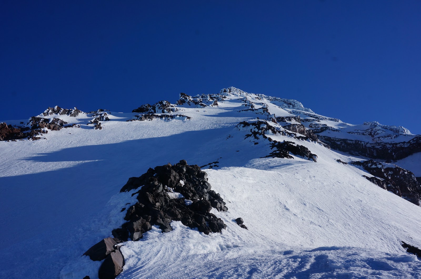
Current Route, Avalanche, Skiing, and Snow Conditions

After you've looked at our route briefs, please read the conditions reports on this blog.

We are renewing efforts and placing a higher priority on providing routine blog posts on this blog throughout the season.  We have spent a good deal of time updating the background mechanics of how the blog works.  You can now subscribe to RSS feeds for this blog and it will come up in your news reader when a new conditions report is made.

Look to this blog first before calling!

You're likely to get just as good or better information here than from a ranger at the desk who's trying to juggle selling climbing passes, issuing permits, registering climbers, and giving resource protection information.

Climbing Permits, Reservations, and the Climbing Fee

This information changes from year to year, but stays the same, usually for each calendar year.

For permits, reservations, and information on the climbing fee, please choose the "permits and reservations" link to the right.

Conclusion

Thanks for being patient with us.  We've updated many of our systems in the last 6 months.  It will take us some time before everything is up and running smoothly.

Thursday, May 11, 2017

Tahoma Glacier (May 10th, 2017)


Kautz Glacier (May 10th, 2017)

Kautz and Kautz Headwall

Fuhrer Finger (May 10th, 2017)

Nisqually Iceflow, Wilson Cleaver and Fuhrer Finger

Fuhrer Finger and Fuhrer Thumb

Little Tahoma (May 10th, 2017)

SE Face of Little Tahoma

Hogsback accessing the Whitman Glacier via the Ingraham

Emmons-Winthrop Glaciers (May 10th, 2017)

Winthrop Glacier

Winthrop Shoulder

Emmons Glacier and Steamboat Prow


Liberty Ridge (May 10th, 2017)

Exiting the Carbon Glacier onto the toe of the ridge
Lower Liberty
Lower Liberty to Thumb Rock
Liberty Ridge

Upper Liberty/Black Pyramid
Willis Wall


Ptarmigan Ridge (May 10th, 2017)

Large serac collapse through the route
Ptarmigan Ridge

Ptarmigan Ridge/Liberty Cap glacier

Mowich Face (May 10th, 2017)

Sunset Ridge, Edmunds Headwall

Central Mowich Face

North Mowich Glacier

Sunset Ridge (May 10th, 2017)

Sunset Ridge

South Mowich Glacier


North Mowich Glacier/Edmunds Glacier

Emmons Glacier Route

Here are a few more pictures of the Emmons Glacier from May 9th. The overall condition of the route is fantastic! The warm up from last week really did a great job of creating a firm snow surface up to 11,500 ft. Above this point is was a mix of wind scoured snow and small wind drifts.
Generally speaking this time of year the route climbs up the corridor, and traverses north along the alpine meadow out to the Winthrop shoulder.  From there it is straight up to the summit. The distance from Camp Schurman to the summit is approx. 2.25 miles.


Along the route shown in a previous post, there were only 4 crevasse crossings. All of them were minor and easy to step across.  The Ice cliff along the North side of the corridor is very filled in and provides many options for access onto the corridor.
There were many options to the summit from 13,000' up. The traverse out to/from Liberty saddle looked like a good option for parties if straight up doesn't go.
The road is still closed to White River but is snow free. From the Ranger Station to the camp ground the road is mostly snow covered.


Tuesday, May 09, 2017

Emmons Glacier Route

This is just in from the rangers at Camp Schurman:  KML Emmons-Winthrop Glacier Route.

Looks like a good direct route this year.