Friday, May 31, 2019

Emmons-Winthrop 5/29/19

View of Camp Schurman & Steamboat Prow from 11,000ft. 
Stormy conditions over Memorial Day weekend kept crowds to a minimum on the east side of Mt. Rainier but high pressure building over the week/weekend will undoubtedly bring many climbers to Camp Schurman and up the Emmons. As of 5/28, cloud caps, new snow instabilities and thinly covered crevasse bridges had kept anyone from the top of the route but multiple parties found success in the later part of the week.


A view of the Emmons and Winthrop Glaciers from atop Steamboat Prow.
Memorial Day weekend storms dropped significant precipitation (up to 50cm) accompanied by strong winds that left the route blanketed in snow and many crevasses covered up by thin bridges. There were multiple incidents and reports of climbers punching through bridges that showed no evidence of their existence. As freezing level continue to rise throughout the weekend, climbers should pay extra attention to the boot pack they are following as bridges soften and crevasse fall hazards increase.


Teams leaving camp Schurman for the top.
Weather forecasts have been fairly accurate over the last few days calling for calm, clear skis in the morning and thunderstorms in the evening. Despite the ideal early morning and afternoon climbing weather, these thunder cells have grown rapidly and intensely as they move up onto the mountain by mid afternoon. Climbers should plan accordingly to be back off the route before these storms move in and should take head as they start to see signs of cumulus buildup.


A tracklog photo from Camp Shurman to the summit. Notice the route climbs
"the Corridor" on the Emmons Glacier before traversing north around 12,300"
in order to link up & ascend the Winthrop Shoulder. Again at 13,600" the
 route cuts climbers right towards Liberty Saddle and on to the summit.
Under current conditions, multiple routes to the top of the Emmons and Winthrop Glaciers exist for those that are willing to route find on their own. The 'standard' route has been taking climbers up the corridor, across the Alpine Meadow, up the Winthrop Shoulder and traversing out towards Liberty Saddle. Slight variations will undoubtedly occur on a regular basis as last week's snow sees it's first major warm up. Climbers should stay heads-up on their climb, keeping an eye out for sagging bridges, holes in the boot pack and fissures on the snow surface. Sunny skies and moderate winds over the weekend will no doubt build for one of the better climbing windows of the 2019 summer season thus far!

Monday, May 27, 2019

Memorial Day 5/27/2019


Ski tracks with Mount Rainier in the background

Memorial Day

A day of remembrance. This holiday, originally known as Decoration Day, was created after the Civil War. Following World War II, the holiday gained favor from the public and was renamed Memorial Day in 1967.  This three day weekend is the unofficial beginning of the summer climbing season on Mount Rainier and mixes in a time for reflection with a change of the season.

View down the Winthrop Glacier
The climbing ranger staff takes time this weekend to remember our own rangers who have left us.  Phil Otis and Sean Ryan lost their lives during an overnight rescue on the Winthrop Glacier on Mount Rainier in 1995.  Nick Hall lost his life during an upper mountain rescue on the Emmons Glacier in 2012.  A Valor Memorial was constructed in Longmire to honor rangers who lost their lives at Mount Rainier while in the act of saving or rescuing others. The memorial can be found across the Nisqually River from Longmire, near the Community Building.

Winthrop Glacier with a view of the Puget Sound in the background
Wherever you find yourself this Memorial Day Weekend, take a moment to reflect.  The landscape and views around Mount Rainier can offer insight and perspective to memories, and hopefully be a place to create new ones full of wonder and awe.  

If Mount Rainier is your destination remember to check the local forecast and park website for  road openings. This can be a busy time of year for park visitation and entrance stations are working hard to keep traffic lines to a minimum. Park Webcams are another good way to see current conditions. Have fun, say safe, and be kind to your neighbor.

Sunday, May 26, 2019

Inter Glacier May 26th, 2019

Views down the Inter Glacier into Glacier Basin 
With the opening of Highway 123, Highway 410, both Chinook and Cayuse Pass and the White River road, the Inter Glacier and Camp Schurman are now much more easily accessible for the summer season. Climbing rangers were able to snap a few shots of the route up the Inter Glacier just before the stormy, weekend weather settled in. Surprisingly, the only evidence of activity in the area was one set of ski tracks down the middle of the glacier.
Plenty of  untouched snow looking toward Steamboat Prow
Despite the relatively high snow line this spring, good snow coverage still exists from Glacier Basin and above. Skiers can expect to be hiking there skis up the trail, through patchy snow for roughly 2.5 miles before coverage becomes consistent enough for skinning. Coverage on the glacier remains very filled in and planar with minimal open crevasses. Climbers and skiers should still use caution when approaching any of the convexities within the terrain as they often harbor crevasses.
Widespread natural avalanche activity throughout the area
Although surface conditions held good corn in the late morning hours, natural avalanche activity was prevalent throughout the basin.  Stormy weather over the weekend continues to produce strong winds, low visibility and new precipitation that will undoubtedly decrease the stability of the snowpack. Skiers should come with the necessary equipment and skill sets to assess the snow stability and the terrain appropriately. Once the weather clears out and the new snow begins to settle, there will be plenty of great skiing for those willing to come and get it!

Friday, May 17, 2019

Ingraham Direct - 05/17/2019

Storms stacked up across the Pacific Ocean. Photo: NOAA

After an exceptionally dry and sunny period in early May, the weather and snow conditions on Mount Rainier have returned to a more typical pattern for this time of year. The upper mountain has received well over a foot of new snow in the past few days. Guides and the Northwest Avalanche Center have reported significant wind slab and storm slabs above Camp Muir. In fact, no group has gone above Ingraham Flats in the past few days due to this increased avalanche hazard. It may take some time after these storms for the snowpack instabilities to stabilize. 

Visibility has been fair-to-poor for most of the week and navigation has been challenging, even on the Muir Snowfield. There are no wands on the snowfield and the bootpack has been frequently obscured by new snow. If you are planning a trip up the snowfield, be prepared with a GPS and knowledge of how to use it before you leave the parking lot. It is easy to get disoriented on the snowfield, especially on the descent, and many parties have become lost in similar conditions in the past.

Remember to check the Mount Rainier Recreational Weather Forecast and the park webcams as part of your planning process before coming to the mountain.

Friday, May 10, 2019

Emmons-Winthrop 5/9/2019


Emmons-Winthrop Glacier as seen from the prow.
Rangers climbed the Emmons-Winthrop with good weather and varied snow conditions. The route can be climbed several different ways right now. Rangers made tracks from Camp Schurman to the summit on routes climbing up the Winthrop shoulder and the Corridor. Overall the routes are straightforward and crevasses are filled in making for relatively direct travel to the summit. The route options above 13,400’ that cross the bergschrund have not been explored yet for the season. The current tracks traverse out to Liberty saddle at this elevation before returning to the summit. 


Climber approaching 13,400' on the Winthrop Shoulder


Surface conditions along the traverse to Liberty Saddle

The uphill travel on the Winthrop Shoulder is favorable over the Emmons Corridor. The surface conditions on climbers far right side of the shoulder holds excellent cramponing with supported smooth scoured snow all the way to 13,400'. Most of the large crevasses on the Emmons taper down as they reach the shoulder so the crossings are smaller and there are less of them to navigate. Climbing up the face of the shoulder is steep but can be managed easily with good travel technique. A few small crevasse crossings and sagging snow bridges will be encountered between the face and Camp Schurman. An early start is recommended, once the sun has softened the snow on the surface it can make the face considerably more difficult to climb.


Surface conditions in the Alpine Meadow
The Emmons Corridor route is holding a large amount of wind blown snow in the alpine meadow zone. This section of the route between 11,000' to 12,600' has unsupportable soft snow with boot top penetration. Getting from the Corridor to the Alpine Meadow is not straightforward as it has been in the past. There are different options, but all of them with unique route finding. The traditional snow passage leading off the corridor to the meadow is a mix of large seracs, sloping blue ice, and drifts of deposited snow. Use caution when passing through this zone as surface conditions warm. The corridor from 11,000' down to Camp Schurman is generally smooth with minor crevasse hazard. 

Climber approaching the traverse to access the Alpine Meadow
Corridor surface conditions

With a high pressure system in place over the past week, the mountain has been beautiful, sunny and warm with freezing levels rising over 10,000'. The extended forecast is calling for more of the same. Go to the Mt Rainier Recreational Forecast to get the latest.

Climber on the Winthrop Shoulder just above the face


The early birds get the best view!  Have fun, be safe!


North and West Side Conditions Update 5/10/2019


Carbon glacier and Liberty Ridge
      This past week of excellent weather allowed a pair of climbing rangers to circumnavigate the mountain and get eyes on many of the climbing routes. As a general trend, many of the routes on the mountain are holding less snow than average for this time of year but are still in good shape. This post will focus mostly on the routes on the North and West sides, for specifics on the Kautz, DC, or Emmons-Winthrop, see those specific blog posts.

Curtis Ridge: The lower half of the route to the Gendarme is snow covered. The upper cliff bands appear to be quite dry and ice runnels were not plainly visible.
Curtis Ridge and the Carbon Glacier, viewed from the Russell Glacier
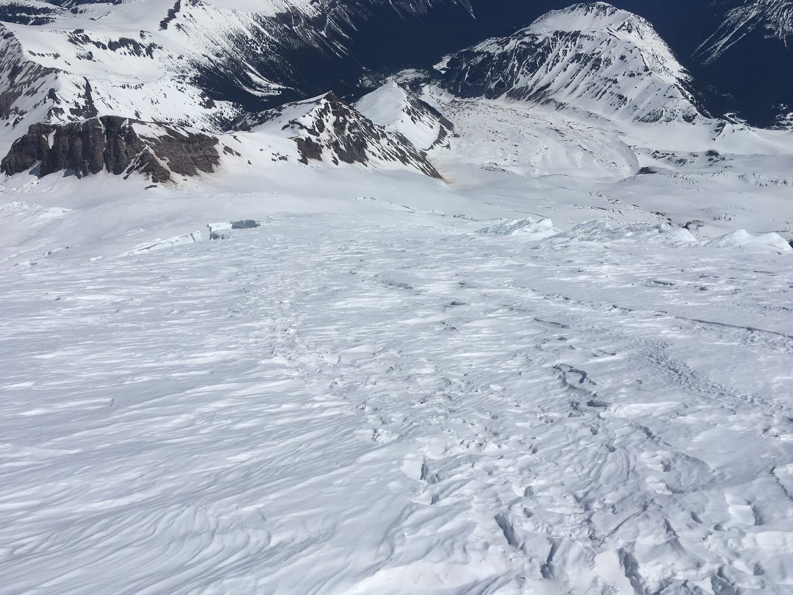
Liberty Ridge and the Carbon Glacier: The lower Carbon is relatively filled in, allowing what appear to be at least 2 viable approaches to Liberty Ridge
The Carbon Glacier and North side of the mountain
 Mowich Face Routes: All routes appear to have possible bergschrund crossings, the Edmunds Headwall presents the most complicated looking bergschrund crossing. No ice fall debris was evident, but the cliffs still loom quite large.
The Mowich Face and Edmunds Headwall
Sunset Ridge: The approach via the Puyallup and South Mowich Glaciers are filled-in and present few navigational challenges. The ridge itself appears snowy all the way to the top.
Lower Sunset Ridge from the South Mowich Glacier
Tahoma Glacier: This route appears to be quite broken above about 9500 feet. The lower Tahoma Glacier from Glacier Island up to 9500’ offers reasonable passage to the Tahoma Cleaver. The Sickle has recent-looking debris from serac fall.
The upper Puyallup Glacier
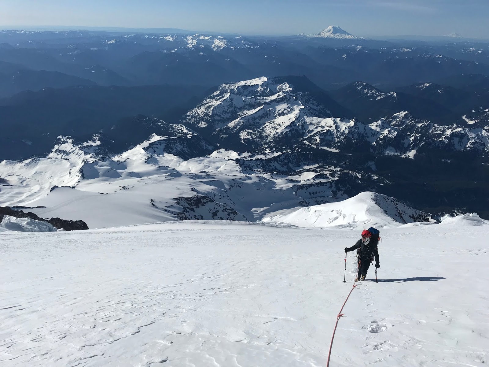
Success Cleaver: Largely snow covered with bits of rock poking out.
Success Couloir: Bergschrund still appears to be passable. Headwall melting out with lots of exposed rocks
A Climbing Ranger ascending early in the morning. Success Couloirs in the background.
With the unseasonable warm temperatures forecasted for the coming weekend, be prepared for changing conditions on many of these routes. Be cognizant of your travel timing, and be aware of the possibility of wet loose and wet slab avalanches on all aspects. As always, check the weather forecast before departing and be prepared.

Thursday, May 09, 2019

Gibraltar Ledges May 8, 2019

Looking back towards Camp Muir and the ledges along Gibraltar Rock
As the high pressure and sunny skies continue to dominate the region this week, climbing rangers had an opportunity to climb Gibraltar Ledges. Once the original guided route up the mountain, “Gib” Ledges is still an engaging and direct route to Camp Comfort and onto the summit. Due to it’s S/SW aspect however, the snowy ledges that make the route viable quickly melt out each season. Based on conditions encountered by rangers this week, the route may melt out sooner rather than later with the continued warm weather.

Easy, albeit firm, early morning booting up and across the Cowlitz Glacier will gain you the south saddle at the base of Gibraltar Rock. From here, the route is fairly straight forward as you traverse west along the base of Gib Rock. Climbers should be cognizant of overhead rockfall and exposure to steep, firm slopes below. As you work west towards Gibraltar Chute and the Nisqually Icefall, the exact route may vary slightly depending on snow coverage. As upper Gib Chute comes into view, the route towards Camp Comfort will become clear. Snow in the steeper pitches of the chute was wind packed and made for easy booting. Two pitches of running belays had rangers to the top of the chute and up to Camp Comfort without issue. Although only one tool was necessary for ascending the softer surface conditions, two tools or ice screws may be warranted if the snow becomes firm or icy. From Camp Comfort, the route easily ties back into the wanded Ingraham Direct for quick travel to the summit.
Finishing off the 2nd pitch of steep terrain in Gibraltar Chute
For those climbers looking to attempt an alternate or simply direct route to the top of Mt. Rainier, Gibraltar Ledges is an enjoyable and engaging option. Route finding, moderate belayed climbing and exciting exposure make this a great option for those looking to put their mountain skills to good use. As snow continues to melt out on the ledges, climbing security diminishes and rockfall hazards increase so an attempt sooner rather than later may be prudent. Climbers can also get a good visual on the Gibraltar Ledges while driving up to Paradise and ascending the Muir Snowfield. If you’re fortunate enough to get on this route before it melts out, it’s sure to be a worth while endeavor!

Track Log of the route linking up with the Ingraham Direct above Gibraltar Rock

Wednesday, May 08, 2019

Ingraham Direct Conditions Update May 6th

This weekend’s warm weather and sunny skies brought climbers and skiers to the slopes of Mount Rainier.  The Ingraham Direct route is beginning to see ascents from independent climbers as well as the guide services.  The route is very direct - currently 3.5 miles Camp Muir to the creator rim.  The climbing route ascends the Ingraham Glacier above Ingraham Flats (avoiding Disappointment Cleaver at the moment). There is one small plank spanning a crevasse (around 11,600’) and one ladder (around (11,800). Both of which are fairly benign crossings.  The route ascends to Camp Comfort and climbs directly to creator rim from there.  For an in-depth description, and descriptions of the E/W, Kautz Glacier and Liberty Ridge routes, see the links to the right.

With the forecasted warm weather, be heads-up for rockfall when climbing above Camp Muir (especially between Camp Muir and Ingraham Flats), as well as loose wet avalanches on solar slopes at lower elevations.

The snowpack on the ID and above Camp Comfort is relatively thin.  We highly recommend roping up while climbing the ID route, as there are many open and hollow crevasses that warrant the security that a rope can provide.

Lastly, make sure to pack out what you pack in and do your best to keep the mountain looking pristine for everyone.  Be on the lookout for micro trash and litter.  Even if it's not yours, throw it into a pocket and dispose of it once you reach a trash can.

Looking up the Ingraham Direct from Ingraham Flats.
Descending the Ingraham Direct, about to cross the lower plank.
Add caption

Sunday, May 05, 2019

Little Tahoma May 8, 2019

Ascending the to the base of Little Tahoma. The Disappointment Cleaver in the background. 
Although often overlooked by many as they set their sights upon the summit of Mt. Rainier, Little Tahoma offers a different kind of experience for those climbers or skiers willing to put in the effort. Standing 11,138 ft. tall off the SE shoulder of Rainier, “Little T” is a prized summit known for its seclusion, exciting summit scramble and incredible corn skiing. As summer like conditions continue to dominate the PNW for the majority of May, parties have already been taking advantage of the weather to try their luck on this climb.

Early this week, rangers had the opportunity to traverse from Paradise to Camp Schurman with a pit stop on the Whitman Glacier to attempt a climb on Little Tahoma. Although approaching Little T from the Frying Pan Glacier via Summerland is the common route, the roads still aren’t open yet to the east side of the park.

Given the spring diurnal cycle of the snowpack that is typical for this time of year, timing is everything if approaching from Paradise, crossing the lower Cowlitz Glacier and ascending to the Whitman. Steep SE aspects that drop onto the Cowlitz quickly become touchy and reactive by midday given the solar radiation they receive. Likewise, SW aspects across the basin become dangerous while ascending to the Whitman Bench. Climbers should plan their itineraries accordingly and pay attention to changing surface conditions in order to minimize exposure to loose wet avalanches. If the snow your traveling upon becomes slushy, and ski poles easily plunge 15-30cm’s into the surface, that’s a good indicator of unstable snow.

Natural avalanche activity along the approach to the Whitman Glacier. 

Although there are a few different options in order to gain the upper Whitman Glacier, most routes will will require roughly 7 miles of travel and nearly 5,000 ft of elevation gain to reach the base of the SE face of Little Tahoma. Ample camping options abound here and climbers should strive to adhere to LNT practices in order to preserve not only the landscape but the isolated feel of this climb. From roughly 9,000’, it’s a 1,800’ push up the steep snow of the SE face and then another 300 ft scrambling, hiking and or climbing on rock. Depending on snow conditions, the last 300 ft of climbing can vary greatly, but is exposed and easily warrants the employment of a rope and a basic climbing rack.
Climbers ascending the last few hundred feet to the summit

Whether you’ve climbed Little T over hundred times before or are looking for a new adventure, this route is a classic that shouldn’t be missed under these conditions!

Kautz Glacier Conditions

A climber on the upper Nisqually glacier. NPS photo.
 
Rangers climbed the Kautz glacier to the summit on May 5. Snow conditions on the approach ranged from firm in the early morning hours to very soft and slushy as the temperatures rose. The trail-breaking was more than a foot in the early afternoon on the Turtle Snowfield. The campsites at the Castle and the rock step are all still covered with snow. There was a small trickle of water at the Castle but none above that camp.

The rock step was exposed, requiring a 20 foot down climb to the snow below. The traverse to the ice chute on the Kautz glacier was free of ice debris but there was some old avalanche debris that was tricky to cross.

The ice pitches were 100% snow but good ice for screws was easily found on the climbers right side of the chute. The route was easily protected. The snow in the chute had a one inch crust with unconsolidated snow below. With several more days of good weather ahead the snow may consolidate to neve soon.

Above the chute the crusty snow continued to the summit, making trail-breaking difficult. The upper Kautz and Nisqually glaciers are relatively smooth with only a few large crevasses to end run.

We expect the route conditions to come into form nicely in the next few weeks.

More info on this route can be found in our Kautz glacier route description.

A climber nearing the top of the ice chute on the Kautz glacier.
 

Westside Snaps


During a recent aviation training to Glacier Island (6100’ near the Tahoma Glacier) the park helitack crew was able to snap a couple photos looking up at the Tahoma and west over the Success Cleaver.  With the Westside Road open to Fish Creek (3.1 miles from the Paradise Road), climbers are already able to access the routes on the west side of the mountain.  Some strategies to approach these routes include biking the Westside Road from beyond the closure to the trailhead and climbing up and over the mountain, descending the standard route back through Camp Muir and doing a vehicle shuttle.


Friday, May 03, 2019

Inter Glacier and Camp Schurman Update 5/2/2019


With great weather on tap this weekend and into next week, climbers are starting to consider objectives accessed from the east side of Mt. Rainier National Park. Before you head to Mt. Rainier, be sure the road is open first!


The Inter Glacier and Emmons-Winthrop route

The White River entrance to Mt. Rainier remains closed to the public. Crews from both the park and Washington DOT are working hard to clear snow and remove fallen trees from the roadways. Check the park’s Road Status page for updates.

The White River entrance station is currently scheduled to open May 24th. Keep an eye on the Operating Hours and Seasons page for updates.

In the spirit of preparing for the climbing season, rangers conducted a patrol to Camp Schurman earlier this week. The trail from the white river campground was mostly snow covered to Glacier Basin. Rangers found the Inter glacier to be well covered with snow and without any open crevasses. Expect crevasses to begin opening up near convexites and steep roll-overs in the coming weeks if warm and sunny weather continues.

The Winthrop glacier has a few pockets of open crevasses between St. Elmo pass and lower Curtis ridge. During this warming period, it is always good practice to give open crevasses a wide berth. Since the winter snowpack is well below average, snow bridges spanning crevasses may be much thinner and less supportive than usual.


St. Elmo pass (center left) and lower Wintrop Glacier

Wintrop Glacier and lower Curtis Ridge
A glimpse of Liberty Ridge

Once at Camp Schurman, rangers spent time getting the camp ready for the season by repairing damage incurred by the sustained winter winds, setting up the webcam, and digging out the toilets. Check out the Camp Schurman webcam. The camera is a little foggy at the moment, but it should improve as temperatures rise over the weekend.

Winter still holds a firm grasp on the upper mountain, with high winds and 5-10 inches of new snow observed earlier this week.  Evaluate avalanche hazard as you travel, as the upper mountain still has a winter-like snowpack above 10,000’ elevation. High winds transported much of the new snow, and there may be lingering pockets of instability / avalanche hazard despite the forecast of warm, sunny days this weekend.  As temperatures rise, be conscious of wet-loose slides that may travel much farther downslope than you expect. Best practice for traveling in avalanche terrain this time of year includes bringing a parter, carrying avalanche rescue gear, and knowing how to use it.


Climbing season is right around the corner, and now is the time to pay the climbing fee.

Fees and Permits:

For a climbing permit, climbing fee, and reservation information, please visit the park climbing page. Climbers need to both pay the cost-recovery fee (Pay.gov) as well as register to climb (get a permit).

More info can be found at: http://mountrainierclimbing.blogspot.com/p/climbing-fee-and-registration.html

Thursday, May 02, 2019

Little Tahoma From Paradise - April 24, 2019

This is a fantastic early season objective from Paradise before the White River entrance opens.  The route ascends the Muir snowfield, turning east just below Anvil Rock, and traverses the Cowlitz and then Ingraham Glaciers before ascending the Whitman Glacier to the summit of Little Tahoma, which involves some exposed 3rd to 4th class rock climbing.  There is quite a bit of glacier navigation and route finding involved.

The view from the summit of Little Tahoma - 4/24/2019
Don't forget to pay the climbing fee and get a climbing permit.  Accessing any terrain on a glacier or above 10,000 feet requires a climbing permit and payment of the Climbing Cost Recovery Fee.  The Paradise Wilderness Information Center opens Friday, May 3rd, for weekends.  You should pay your fee online before obtaining your permit at the PWIC.  Click on this link for more information:

https://www.nps.gov/mora/planyourvisit/climbing.htm

Climbing rangers are currently at Camp Muir and Camp Schurman getting the high camps set up for the coming climbing season.  Look for more frequent blog posts about the Disappointment Cleaver and Emmons Glacier routes in the near future!

Nearing the Cowlitz Glacier, below Anvil Rock, en route to Little Tahoma - 4/24/2019
Looking back across the Cowlitz Glacier, around 8700' - 4/24/2019
Looking SSE from near the summit of Little Tahoma - 4/24/2019
The upper Whitman Glacier and summit of Little Tahoma - 4/24/2019
A good view of the Disappointment Cleaver route and the upper Ingraham and Emmons Glaciers    4/24/2019
See you on the mountain!

Wednesday, May 01, 2019

Ingraham Direct Conditions May 1, 2019

The view up-mountain from Ingraham Flats. NPS photo

Winter-like conditions persisted through the last week of April 2019. The upper mountain received more than a foot of snow on the 28th and again on the 29th.

The new snow came in as low-density powder with very little wind. That made for tough trail breaking and, for a short period, ideal powder snow conditions. Wind quickly moved in however and consolidated the new snow. This also resulted in an elevated avalanche danger that kept the guides and rangers from attempting the summit.

On May 1 an intrepid group of three independent climbers broke trail, found a route up the ID and made it to the summit in cold and windy conditions. Congratulations to those hearty climbers.

The guides are just starting their seasonal operations and so there is no established route as of yet, but they will start pushing one up the ID in the next several days.

The weather looks fairly good through the forecast period so we are expecting a busy weekend on the mountain. Keep in mind that avalanche and snow surface conditions will be changing rapidly as the upper mountain transitions from winter to spring. Please use caution when climbing and be prepared to assess the avalanche danger and climbing conditions for your team.


Climbing Rangers descend from Ingraham Flats. NPS photo