
This year, the weather has been predictably less good. Not bad? Well, there have been bad days, but many of the predicted poor weather periods have been somewhat less intense than what many of the forecasted models have indicated - or at least how I would interpret them in the winter.
Last Monday, because of the models and forecasts, I scrubbed my planned trip to Camp Schurman thinking it was going to be poor weather. It ended up being good enough to get up to Camp Schurman easily. I should've gone.
So I thought I'd show some of the forecast tools I use, and offer show what the actual conditions are compared to what the models currently say. This may help us interpret them.
First of all, I look at the UW MM5 WRF-GFS 36km 500mb Temp/Pressure/Winds model. Here. The model for this hour looks like this:

This has been a fairly typical weather pattern this summer. Low pressure centers have been developing in the Gulf of Alaska and tracking down the BC coast to end up right over western Washington. This is generally bad and brings cool, moist, and unstable air to the area.
Next, I look at the UW WRF-GFS 4km Profile for Mt. Rainier. Here. It is a vertical cross section of the atmosphere. This is what it looks like for the current forecast period:
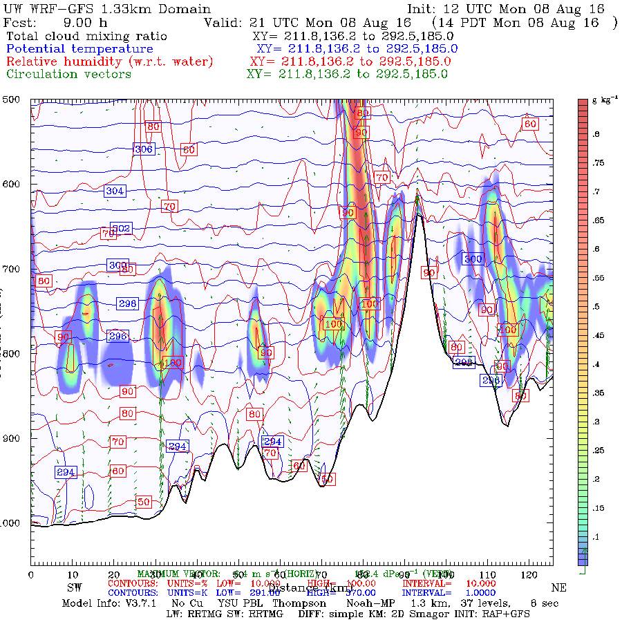
The elevational profile of this graph is roughly from 0 feet to around 16,000 feet. The rainbow colors are the presence of clouds. So currently, at Camp Schurman, I would be looking at the right part of this picture, near what looks like a 'peak'.
Next I like to cross reference these models with a different view of the same model inputs, the point data meteograms from the NWS. Here. This is what it looked like for this forecast period:

You can see right now that we are 'peaked' for precipitation and cloudiness (middle graph / brown and blue lines respectively). The bottom graph indicates lightning!
The temperature / winds aloft forecasts was for calm winds. Here. I think this was probably the most important forecast component. High winds in the forecast would've made things much more difficult and hard to manage myself.
What did I get on the way up this morning?
At 08:30 in White River, I had mostly cloudy skies, with a few sun breaks - all the way hiking in to the toe of the Inter Glacier at 7600 feet. It began to snow lightly at first, then moderately. Winds, from the north at 5-10 mph. Snow level was about 8000. It pretty much stayed like this all the way to Schurman. It wasn't bad, at all. Here's what it was like in Glacier Basin:

Here's a picture of what I'm looking at at Camp Schuman currently:

Here's a picture of the Camp Muir webcam, right now:

Conclusion:
Yes, the visibility was reduced to 200 yards. Yes, I got a little snow on me. But it was generally a good hike up! If you have a GPS and can use it like a boss, or are experienced with a map and compass and are prepared (dressed) for snow falling, this isn't horrible weather to navigate in. The guide services were in the area with me (I heard them, but seldom saw them) and made it up where they are currently digging tent platforms. So the guides had a decent ascent up this morning, too.
In my experience, the weather forecast resources are pretty right on. However, I'm often reminded that the summer softens, somewhat, the blow of the hammer of the gods. In the winter, this forecast would likely have deterred me, wind or no wind.
** Update ** Plus, I just heard that RMI summitted today. So....
** Update ** Plus, I just heard that RMI summitted today. So....
I'm glad I came up today!
- Stefan