Wednesday, July 30, 2025

Disappointment Cleaver Update 7/29/2025

 Overview

It’s been a windy week at Camp Muir, but many parties have successfully summited the mountain. The Disappointment Cleaver route is in good shape and the weather for the upcoming week includes low to moderate wind speeds and several days of optimal climbing weather moving into August. Expect busy weekends at camp and on the route this time of year and consider the Emmons-Winthrop route as a less-traveled alternative. 

As a reminder, the Public Shelter remains closed for the season at Camp Muir so bring your own bivy/tent setup. 

Disappointment Cleaver

The walk up from Paradise is snow-free to Pebble Creek (where running water is plentiful, but make sure to have a water purification system). The snowfield is free from crevasses at the moment, and it's a good idea to make a GPS track of your ascent route in the event that whiteout conditions occur during your descent. At Camp Muir, it’s worth noting that there are no trash services on the mountain. Please carry your trash out and practice Leave No Trace principles.

Above Camp Muir, the route crosses the Cowlitz Glacier where both rockfall hazard and crevasse fall danger exist - don't forget to rope-up and helmet-up right out of camp.  Cathedral Gap has lots of exposed rock, and just past Cathedral Gap on the way to Ingraham Flats there is some exposed firm glacial ice.  Take care while traveling on this ice - it's not steep, but a slip or trip would result in landing on a very firm surface.  There is a significant rockfall hazard here - move efficiently, but with deliberate footing, through this rocky and icy section just above Cathedral Gap and right below Ingraham Flats.  

Looking back on the Ingraham Glacier from the base of the Disappointment Cleaver. Climbers are traveling through the Bowling Alley in the center of the photo. 


The High Crack Ladder on the Ingraham Glacier, below the Disappointment Cleaver.

The route above Ingraham Flats Camp crosses a horizontal ladder before traveling through the Ice Box and Bowling Alley, where it’s important to move quickly to reduce your exposure to overhead hazard. Once on the Disappointment Cleaver itself, avoid kicking rocks down on parties beneath you by stepping carefully and not letting your rope drag. Above the Cleaver, the route switchbacks up to two additional horizontal ladders. During busy days on the route, please be extra courteous and communicate with other rope teams if trying to pass.  Consider stepping off the route and waiting versus trying to climb around with difficult footing. Traverse to the Emmons Shoulder above the ladders and ascend until the route wraps back toward the Crater Rim. If your party seeks shelter from high winds in a steam cave near the crater, please remember to pack out all of your trash (and we’d greatly appreciate it if you pick up any additional trash you notice in the area to keep the mountain clean!). 

Climbers navigate a ladder above the Disappointment Cleaver (seen in the right of the photo).

Climbers traverse an exposed section of the route. A handline is seen on the left.

Use caution on the descent with the warming temperatures typical for this time of year. Snow conditions are changing rapidly. Consider using techniques like belaying for sections of the route and remember that pickets are an essential piece of equipment for building snow anchors on this mountain; it’s recommended to carry two pickets per person

Additional Information 

Remember, practice Leave No Trace principals throughout your entire visit to Mount Rainier National Park. Do not litter in your national park. 

A climbing permit and payment of the annual climbing fee are required to climb Mount Rainier. More information can be found on the Mount Rainier National Park's Website. The Paradise Wilderness Information Center (PWIC) is open for the season with hours of operation between 7:30am - 5pm.


Sunday, July 27, 2025

Emmons-Winthrop Route Update 7/27/25

The final weekend of July was perplexing at Camp Schurman. Temperatures were pleasant, winds were moderate, and the route to the summit was quite good; yet there were only a handful of climbers in camp each day. 

Conditions continue to progress towards late season norms, but all things considered, the Emmons-Winthrop route climbs well for this time of year.

Emmons-Winthrop route approximation (blue line) on 7/26/25


Route Description: 


Inter Glacier

After leaving Glacier Basin, and following the trail up the Inter moraine, stay climber's right and avoid the lowest snow patches. The Inter Fork of the White River is flowing under these lingering snowfields and the risk of punching through the snow and getting swept away by the creek are not worth taking. Follow intermittent climber's trails over rocky slopes until you arrive at the toe of the Inter Glacier.

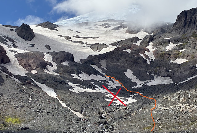
Recommended travel line shown climber's right of the Inter Fork of the White River . Avoid the snow slopes with running water underneath (denoted by the X) photo: 7/27/25


Travel up the Inter Glacier remains straightforward and efficient. Clean running water is plentiful and easy to find on the numerous exposed rock islands along the way. There are no open crevasses or exposed ice along the climber's trail up the Inter Glacier. The snow is firm, and some folks may prefer crampons for the ascent.

Inter Glacier travel is quite good for late July - 7/27/25


Camp Curtis to Camp Schurman

This section still requires some downclimbing over loose and somewhat steep terrain with poor footing in order to access the Emmons Glacier. A great description and good photos of this section can be found in the previous Emmons blog post. Once the downclimb is complete, rope up, and follow the obvious climbers trail to Camp Schurman.

Camp Schurman to Summit

From camp, follow the obvious boot tracks up towards the Emmons Flats. Climbers will encounter some sections of exposed glacier ice shortly after leaving camp. The boot pack fades away here, but the navigation is mostly straightforward with some traversing to end-run crevasses. 

The established boot pack accesses the corridor higher than normal (an artifact from old ski tracks from early season). Rangers found a much better way to access the corridor on a solid snow bridge about 200' below the old trail. 

The corridor is sun-cupped and travel requires some French-technique with crampons to save energy. Near the top of the corridor, there are some crevasses popping out that will necessitate some back-and-forth traversing. When leaving the corridor, climbers will find some exposed glacier ice at the bridge that leads to the alpine meadow. This section requires some confident footwork with crampons.

Crevasses crossing near 13,300 ft (7/26/25)


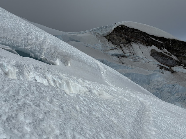
Above the corridor, the route still has good snow coverage. The penitentes cause the trail to be troughed in some sections, but good travel is found off trail in places. The route zig-zags around some large crevasses here. Most notably at 11,900 ft, 12,200 ft, and 12,300 ft. The snow bridge at 12,300 feet is not difficult to ascend or descend but warrants a belay to cross. Rangers found that the ability to quickly lengthen the rope interval between the lead climber and followers greatly aided belaying across this crevasse with a picket anchor; both for the ascent and descent.

A Ranger descends on belay across the snow bridge at 12,300 ft (7/26/25)


The snow bridge over the 12,300 ft crevasse from above (7/26/25)


At 13,200 ft, the route begins traversing towards Liberty Saddle. From Liberty Saddle at 13,600 ft, parties can choose to continue up mostly on snow to the crater rim, or travel up gravelly slopes from 13,900 to the summit.

The traverse to Liberty Saddle (7/26/25)


Equipment

Because some sections of the route involve exposed glacial ice (albeit low angle) carrying a few ice screws is recommended to facilitate anchor building in these areas. The rest of the route is still snow, and picket anchors work very well. Parties should climb with a minimum of 4 pickets per group. Groups of 3 or more should carry at least 5 pickets. Every member of a climbing party should have the ability to build a snow anchor, and plunging an ice axe into the snow is not a viable plan. Ice axes with hammers are a good choice for the route in its current condition.

The Emmons-Winthrop route taken by Rangers on 7/26/25


Permits and Planning

More information on climbing on Mt. Rainier can be found on the Mt. Rainier National Park Climbing Page. Here, you will find information about how to pay the Annual Climbing Fee, obtain a Climbing Permit, and make Reservations.

On behalf of the NPS climbing staff: happy climbing, and we hope to see you at high camp!

Thursday, July 24, 2025

Disappointment Cleaver Update 7/23/2025

First, as a reminder, the Public Shelter at Camp Muir is closed for the season.  Please plan on bringing a tent/bivy to stay at Camp Muir. 

The DC has been in great shape for mid-July, and lots of teams are making it to the summit.  Some unseasonable stormy weather has left a dusting of snow and graupel on the upper mountain.  Expect busy weekends through early-August - this is prime time to climb!  The Emmons/Winthrop Route has significantly less traffic and can offer more solitude this time of year.  

Trail conditions up to Camp Muir are now mostly snow-free until Pebble Creek.  Above Pebble Creek, consider trekking poles and even crampons (or at least some kind of shoe chains if only going to Muir) if traveling early or late in the day when the snow firms up.  No crevasses have opened up on the Muir Snowfield yet - but be aware of rocks melting out in glissade tracks and cornices on the snow rolls above Pebble Creek.  

Cornice collapsing above Pebble Creek, 7200'
 Above Camp Muir the route crosses the Cowlitz Glacier where both rockfall hazard and crevasse fall danger exist - don't forget to rope-up and helmet-up right out of camp.  Cathedral Gap has lots of exposed rock - and just past Cathedral Gap on the way to Ingraham Flats is some exposed firm glacial ice.  Take care while traveling on this ice - it's not steep, but a slip or trip would result in landing on a very firm surface.  There's a significant rockfall hazard here - move efficiently, but with deliberate footing, through this rocky and icy section just above Cathedral Gap and right below Ingraham Flats.  

The route just above Ingraham Flats goes up the glacier until around 11,200' and then crosses over a ladder and traverses to the Disappointment Cleaver.  Don't linger on this traverse - there's overhead hazard from both rocks and seracs.  From the nose of the cleaver the route ascends staying mostly on the spine of the cleaver with a couple of zigzags to climber's left.  

Glacier travel on the upper mountain, above the cleaver, remains fairly straightforward - ascend up from the top of the cleaver, crossing two horizontal ladders, at about 12,800'.  Traverse climber's right once above the ladders, over to the Emmons Shoulder, and ascend for another 600 or so vertical feet until traversing back climber's left towards the Crater Rim. As in other places on this route with overhead hazard, move efficiently on the traverse and plan to avoid congestion on the traverse due to serac fall hazard (see photo below).   

Traverse at 13,000 between the Emmons Shoulder and the route above the Cleaver. 
Surface conditions on the upper mountain off of the boot pack are rough.  Penitentes have formed and have made travel tedious and less secure when passing parties and venturing away from the route.  During these busy days on the route - please be extra courteous and communicate with other rope teams when trying to pass.  Consider stepping off the route and waiting versus trying to climb around with difficult footing. 

Looking down on the Cleaver, 12,700'
 Lastly - we've seen quite a few parties splitting up and climbing solo on the mountain.  Solo climbing or skiing requires a special permit and can be obtained through the Solo Climbing Application.  Please do not split up or off from your rope team on the upper mountain.  Once your rope team ascends past Camp Muir - stick together!  If one person on your rope team cannot keep ascending, come back down as a team.  Do not split up.  

For more info, check out our Disappointment Cleaver Route Brief.  See you on the mountain!


Wednesday, July 23, 2025

Emmons Winthrop Route Update 7/20/25

Conditions on the Emmons Winthrop route remain favorable for climbing as summer stretches on. Rangers at Camp Schurman experienced a variety of mountain weather over the last several days. High freezing temperatures gave way to clouds, wind and even scattered upper mountain snow showers. To close out the weekend the Park saw thunderstorms, hale and heavy rainfall on 7/19.


7/19/25 - Sunset on Little Tahoma

Inter Glacier 

The Inter Glacier continues to lose snow each day, no ice exposed as of 7/21. Hiking up climbers will find the transition to snow at around 7,000' elevation. Please follow the climbers trail to access the snow to avoid impacting the alpine vegetation. No cracks or holes in the Inter were noted. 

7/21/25 - A party begins ascending the Inter Glacier 

Emmons entrance from Camp Curtis

As the glacier recedes, the climb down from Camp Curtis to access the Emmons Glacier has gotten steeper with loose rock exposed. Use caution when making the transition on the descent and ascent of this feature. Use the appropriate travel techniques in this piece of terrain. Rangers watched multiple parties move through the steep rock step, maintaining traditional glacier travel techniques - a fall in this configuration could have serious consequences for the entire team. Teams should be prepared to slow down through here, coordinate with other groups moving through this bottleneck, and watch for rockfall. Some teams have opted to use hip belays in the steeper sections of the trail here, however there are no good rock anchors to rely on. As a reminder, after crossing the moraine the final approach to Camp Schurman is on the Emmons Glacier and climbers are encouraged to rope up for glacier travel. The boot pack crosses over several crevasses between the moraine and camp. 


7/19/25 - A party of 4 ascending up from the Emmons towards Camp Curtis

7/19/25 - The entrance to the Emmons from Camp Curtis

Emmons Winthrop Route

As of 7/20 the route follows generally the same path as it has for the last couple weeks. The route has seen the most change between 11,400' and 13,000' as crevasses continue to open and re-routing of the boot pack occurs. This has led to several old, established boot packs existing in this section that led to dead-ends or less ideal crevasse-bridge crossings. Pay close attention through this zone and record a GPS track on your way up that you can follow back down to avoid wrong turns. Rangers noted with some route finding they were able to increase security over most crevasse crossings. Expect to encounter sections of exposed ice during your climb. Good crampon technique and potentially the placement of ice screws will alleviate exposure in these zones. 


7/20/25 - Broken Terrain on the Corridor at 10900'

7/20/25 - At the top of the Corridor, 11400' - the current boot pack travels 
through this feature.  


7/20/25 - 12250' on the Emmons route


7/20/25 - 13600' the current boot pack traverses far climbers right to the Liberty Saddle with a few large crevasses to cross as you gain the saddle. 


7/20/25 - Sunset from Camp Schurman

Friday, July 18, 2025

Emmons Winthrop Update 7/12/2025

Please read the 07/09/25 Update; many of the important points still apply. 


Overview:


  • Be prepared to assess and navigate unmanaged terrain that involves several consequential crevasse-crossings, exposed traverses on the upper mountain, and constantly changing snow and weather conditions.

  • Accessing the Emmons Glacier from Camp Curtis requires patience and communication with other teams through this bottleneck. Be on the lookout for rockfall and consider belaying the steeper sections, although there are no reliable rock anchors in this area.

  • Accessing Camp Schurman from Camp Curtis involves traveling on the Emmons Glacier and the route leads directly over several crevasses. 

  • As of 7/12/25, the crevasse crossings around 12,400’ require attention, especially on the descent as temperatures warm. Be prepared to belay and run protection, including pickets. The bergschrund snow bridge at 13,500 had several places to cross.


A rope-team descending from Camp Schurman.


The route descending toward "The Catwalk" and the top of "The Corridor."

Warming snow conditions during a mid-morning descent.

The Inter Glacier, 7/13/25

Don't forget to pay the Climbing Cost Recovery Fee and check-in/out at our wilderness information centers at Paradise or White River entrance to receive your climbing permit.


Enjoy the summer sunshine and please Leave No Trace on the mountain!


As a reminder:

The Camp Muir Public Shelter Closes on July 7th for Construction

 The Public Shelter at Camp Muir will close for maintenance and improvements from July 7-September 30, 2025. The shelter will still be available for emergency use only for safety purposes. All climbers and overnight users will need to bring tents and plan to camp.

The emergency radio that has been inside the public shelter will temporarily be moved to the restroom nearest the helipad. This base station radio is to be used for emergencies only to contact the park's dispatch.


Sunday, July 13, 2025

Disappointment Cleaver Update 7/13/25

 It has been sunny and hot up here as we head into mid-July. Freezing levels this past week have been steady in the 15-17k' range and the forecast for the next week looks similar. This extended warm weather and the high sun angle of mid-summer create dynamic conditions on the upper mountain with little to no refreeze at nights. This leads to punchy snow, weak crevasse bridges, and new cracks opening daily. Climbers should approach all crevasses with extra caution and plan to leave early, avoiding the heat of midday when the snow is weakest. 

Disappointment Cleaver

The route remains much the same as described in our previous DC blog from 7/9, so be sure to check that out for more info. 

Addendum 7/15: The left variation has fallen out and currently the right variation, traversing climbers right to the Emmons Glacier shoulder after the ladder at 12,900', is the primary DC route. 

Here are some photos from an ascent on 7/12:

Looking down from Dunn's Roll near 10,600' on the east side of Cathedral Gap


The ladder at High Crack near 11,400'


Looking back at the 11,400' traverse under the Ice Box and Bowling Alley to access the cleaver. Teams are encouraged to move quick through this section of high overhead hazard.


Penitentes above the cleaver.


The ladder at 12,900'. The boot pack splits just above this ladder where teams can choose the right or left variation. 


The ladder at 12,900' on the right variation. Note the serac hazard after the ladder, above the traverse towards the Emmons shoulder. 


Widening crevasse and thin bridge at the end of the 12,900' traverse to the Emmons Shoulder. Right Variation


Mt. Rainier casts a long shadow


Additional considerations

-It is always a good idea for teams of two to carry 2 pickets per person, and teams of 3 or more to have at least one picket per person, especially when building anchors for crevasse rescue in slushy snow. 

-Prepare for and prevent the possibility of heat injuries like heat exhaustion and heat stroke by staying hydrated, avoiding climbing in the hottest times of day, and taking more rests as needed to prevent overheating. 

-Never split up with your teammates or leave someone behind. If some needs to turn around, it is the responsibility of the entire team to facilitate that, the well-being of your teammate is more important than the summit. Furthermore, if splitting up leaves someone solo, that is a permit violation. Soloing requires a specific solo permit application and approval. 

-The Public Shelter remains closed till ~9/30/2025 for maintenance. As always, even when the public shelter is open, come prepared with your own tent. 


Thursday, July 10, 2025

The Camp Muir Public Shelter Closes on July 7th for Construction

 The Public Shelter at Camp Muir will close for maintenance and improvements from July 7-September 30, 2025. The shelter will still be available for emergency use only for safety purposes. All climbers and overnight users will need to bring tents and plan to camp.

The emergency radio that has been inside the public shelter will temporarily be moved to the restroom nearest the helipad. This base station radio is to be used for emergencies only to contact the park's dispatch.

Historic construction images

The historic Camp Muir Public Shelter was constructed in 1921 and is the only sleeping shelter available for climbers and visitors who are not part of a guided tour. It is a stacked mortared stone building with a flat roof and wooden details. The shelter is a contributing building to the Mount Rainier National Historic Landmark District and the Camp Muir Historic District, which is at 10,000 feet elevation on the slopes of Mount Rainier. Camp Muir is the primary base camp from which most summit attempts depart.

Historic photos of the Public Shelter, 1921
The buildings at Camp Muir are subjected to hurricane force winds year-round with driving ice, snow, and debris that breaks down exterior finishes and shortens the life span of building components. The public shelter has not received targeted maintenance in over a decade. Work to maintain the building includes repointing of stone masonry, repair of roof, electrical lighting and cook area ventilation, maintenance on historic doors, and repainting of interior sleeping bunks. Work will be completed by NPS staff in accordance with the Secretary of the Interior’s Guidelines for Treatment of Historic Properties.

Climbers resting in front of the Public Shelter, Circa 1930s

Wednesday, July 09, 2025

Emmons Winthrop Update 7/9/2025

The mountain experiences a prolonged stretch of sunny summer weather and climbers continue to work up and down the Emmons route. With warming weather and softening snow, we have seen ice fall from seracs around the Emmons and Winthrop as well as significant continual rockfall from the Curtis ridge and upper mountain. That is all to say that warming temps are having an effect on the mountain. 

7/8/2025 - Inter Glacier

Warm weather and long sunshine of high summer change the mountain daily, so today's route beta may be tomorrow's dead end. Climbers who attempt the Emmons-Winthrop route should come prepared for an unmaintained, wilderness glacier route which requires diligent navigation, careful crevasse-bridge assessment, and self-sufficiency in a remote, alpine environment. 

Rangers noted a significant change in snow coverage on the inter glacier from the start of their shift to the end, with the entrance to the Emmons route becoming slightly more challenging. Accessing the Emmons Glacier from Camp Curtis has become increasingly difficult now that the moraine is mostly snow free, exposing steep, loose rock and dirt. Teams should be prepared to slow down through here, coordinate with other groups moving through this bottleneck, and watch for rockfall. Some teams have opted to use hip belays in the steeper sections of the trail here, however there are no good rock anchors to rely on. As a reminder, after crossing the moraine the final approach to camp Schurman is on the Emmons Glacier and climbers are encouraged to rope up for glacier travel. The boot pack crosses over several crevasses between the moraine and camp. 

As of 7/9/25, the route remains in good condition and follows generally the same path as it has for the last couple weeks. The route has seen the most change between 11,400' and 13,000' as crevasses open and re-routing of the boot pack occurs. This has led to several old, but well-established boot packs existing in this section that lead to dead-ends or less ideal crevasse-bridge crossings. Pay close attention through this zone and record a GPS track on your way up that you can follow back down to avoid wrong turns. When in doubt it, teams have reported that taking the lower boot pack option has been more successful if multiple trails are present. 

7/9/2025 - Emmons Winthrop 


Disappointment Cleaver 7/9/2025

  Overview

 Fourth of July brought favorable conditions to Mount Rainier and climbers found sunny days and overall great weather for summit attempts. Friday through Sunday was quite busy with a full camp at both Muir and Ingraham Flats.  

We are still in a transitional period here at Mount Rainier and any type of conditions can exist at any time. Always be prepared for wintery conditions even if just day hiking up the snowfield. Main hazards associated with this time of year include:

- Rapidly changing and unpredictable weather including winter snowstorms

- Overhead hazard from rock and serac fall

- Thinning snow-bridges over crevasses


Disappointment Cleaver

Hiking to Camp Muir:

On the way up from Paradise, please stick to the summer trail if it is melted out/snow free. If the trail is still buried, please follow NPS wands (markers) through the snow until gaining sections of melted trail. Please avoid trampling the fragile alpine wildflowers and vegetation. 

The Muir Snowfield itself is starting its transition to a summer texture with suncups lining the entirety of its length. Skiers take note, do not expect smooth snow surface conditions if skiing/riding from Camp Muir. 

Always be prepared to navigate to/from Muir in wintery whiteout conditions.

Above Camp Muir:


The National Park Service does not maintain the route; however, guide services on Mount Rainier do significant work to keep the climb maintained and marked with reflective wands. Several areas along the DC have significant exposure to overhead rock and icefall hazard. Remember, if you look up and something can come off the mountain and down on your team, do not take a break there. Continue moving until the overhead hazard is no longer present. 

Above Ingraham Flats, guide services established a small ladder across high crack. Gaining entrance to the Cleaver is still relatively straight forward. Remember, Significant serac fall and icefall exists in this zone. To reiterate from above, do not break here. Appropriate break spots exist once your team is on the "spine" of the Cleaver. 

From the top of the DC the route follows a well-established route to roughly 12,800ft. The ladder at this location still exists and from here the route splits. One is the "older" route travelling fairly direct to the crater. The alternate route travels further climbers-right and gains the Emmons Shoulder to rejoin the existing route at roughly 13,400ft. 

The more direct route still is in use by independent teams and guide services at the time this blog is written. It is important to remember that now with summer temps gaining consistency on the upper mountain, crevasses can open, and snow bridges can collapse. The direct route has several snow bridges that teams will travel over, and climbers should use their discretion when crossing. Beat the heat of the day by climbing early and descending early to alleviate some risk of collapsing bridges. 

The Emmons Shoulder route will traverse out climbers right where teams will cross another horizontal ladder just below 13,000ft. This route overall has less crevasses parties will travel over but the advice remains the same to minimize exposure in warming temperatures. 

Remember, Mount Rainier is a dynamic environment and can host winter storms any time of year. Always check the weather forecast before your climb and never completely rule out the possibility of severe weather/winds affecting your climb. 


Additional Information

- The Public Shelter at Camp Muir is now closed for maintenance since July 7 - September 30. Climbers camping at Muir should plan on bringing and sleeping in tents. 

- Remember, practice Leave No Trace principals throughout your entire visit to Mount Rainier National Park. Rangers went through the Public Shelter prior to its closure after the holiday weekend and collected 30 pounds of garbage left behind by climbers. Do not litter in your national park. 

- A climbing permit and payment of the annual climbing fee are required to climb Mount Rainier. More information can be found on the Mount Rainier National Park's Website. The Paradise Wilderness Information Center (PWIC) is open for the season with hours of operation between 7:30am - 5pm. 

Thursday, July 03, 2025

Disappointment Cleaver 7/3/2025

Parties continue to summit via the DC as summer finally feels like it's arrived for this holiday weekend!  Be prepared to route find and problem solve as the route up may differ from the route down due to changing conditions, which is typical for glacial mountaineering routes. Guide services have installed a horizontal ladder to cross a crevasse as 12,900', above the cleaver. There's still a handline along the nose of the cleaver as well.  As the route continues to change, more adjuncts like ladders, "fixed" pickets and handlines may be added and/or removed.  Use all of these adjuncts at your own risk.  Just because a climbing party or guide used that adjunct before does not mean that it continues to be safe to use as the anchors can melt out or the angle of the glacier can change.  Often times any route adjunct can be climbed around or bypassed, so look critically at the route as you ascend to find the safest course  

Climbers will note an alternative reroute to the route on the DC at around 12,900' that links back to the 'main' route around 13,800'.  This alternative ascends climber's right toward the Emmons Shoulder and avoids many crevasse crossings that the direct route crosses.  As the summer moves on remember that with ever changing conditions - numerous snow bridged crevasses exist throughout the route - use good decision making to navigate safely - and if the conditions or route doesn't seem safe for ALL of the folks in your party to ascend, definitely turn around.  

7/2/2025 - 12,900' bridged crevasse 

We have had multiple instances of crevasse falls from independent climbers over the last few weeks- 
rangers have been seeing a wide spectrum of preparation and knowledge on the mountain. As a reminder, knowing how to perform crevasse rescue effectively with the appropriate gear is paramount. - always have a plan for how to handle self-rescue in the event of an emergency. 

7/2/2025 - Current Route Alternatives


7/2/2025 - Penitentes near the top of the Cleaver
Keep an eye on freezing levels and the weather.  As the temperatures warm up: think earlier starts; as things cool down and get stormy, think a bit later start and be sure to not climb into situations where self-rescue or helicopter-rescue may not be possible.  Enjoy the holiday weekend and see you up high! 

Monday, June 30, 2025

Emmons-Winthrop Update 6/30/2025

Sunset over Curtis Ridge from Camp Schurman


Sunshine and warm weather returned to the mountain over the final weekend of June after a week of cooler temps and light precipitation. It was a busy weekend here at camp Schurman and many teams were able to take advantage of the great weather and find success on the Emmons-Winthrop route.

Warm weather and long sunshine of high summer change the mountain daily, so today's route beta may be tomorrow's dead end. Climbers who attempt the Emmons-Winthrop route should come prepared for an unmaintained, wilderness glacier route which requires diligent navigation, careful crevasse-bridge assessment, and self-sufficiency in a remote, alpine environment. 

The trail from White River campground is 99% snow free to Glacier Basin and above till reaching the Inter Glacier near 6800'. Travel up the Inter is mostly snow and no crevasses have appeared yet along the standard boot pack. 


Steep, loose dirt and rock crossing the moraine from Camp Curtis to the Emmons Glacier below Camp Schurman (6/30/25)


The final step of the moraine before getting on the Emmons Glacier (6/30/25)
 

Accessing the Emmons Glacier from Camp Curtis has become increasingly difficult now that the moraine is mostly snow free, exposing steep, loose rock and dirt. Teams should be prepared to slow down through here, coordinate with other groups moving through this bottleneck, and watch for rockfall. Some teams have opted to use hip belays in the steeper sections of the trail here, however there are no good rock anchors to rely on. As a reminder, after crossing the moraine the final approach to camp Schurman is on the Emmons Glacier and climbers are encouraged to rope up for glacier travel. The boot pack crosses over several crevasses between the moraine and camp. 


Approximate path of the Emmons-Winthrop Route 6/30/25 some extra switchbacks may be encountered


As of 6/30/25, the route remains in good condition and follows generally the same path as it has for the last couple weeks. The route has seen the most change between 11,400' and 13,000' as crevasses open and re-routing of the backpack occurs. This has led to several old, but well-established boot packs existing in this section that lead to dead-ends or less ideal crevasse-bridge crossings. Pay close attention through this zone and record a GPS track on your way up that you can follow back down to avoid wrong turns. When in doubt it, teams have reported that taking the lower boot pack option has been more successful if multiple trails are present. 


Widening crevasse near 12,400'. The boot pack may or may not be the best place to cross when you encounter it (6/28/25).


Teams are encouraged to evaluate each crevasse crossing they encounter along the boot pack as often there is a much better place to cross just downhill or uphill of where the established boot pack is. In some cases, the crevasse may be end run entirely just a short distance from the boot pack so be sure to look around instead of blindly following the trail. Bridges that may have been solid in the AM can often be unreliable by midday after the sun and heat has softened the snow up, so teams should make a plan to be down early and stick to preset turnaround times. 


Large serac fall in the gut of the upper Winthrop glacier. The route traverses above this to/from the Liberty Saddle (6/28/25).


Don't forget to pay the climbing cost recovery fee and check in out our wilderness information centers at Paradise or White River entrance to receive your climbing permit in person. This is a great time of year to be on the mountain with long days and pleasant weather, we look forward to seeing you up here!

Also, check out our last couple blogs on the Emmons for additional info.