Conditions continue to progress towards late season norms, but all things considered, the Emmons-Winthrop route climbs well for this time of year.
 |
| Emmons-Winthrop route approximation (blue line) on 7/26/25 |
Route Description:
Inter Glacier
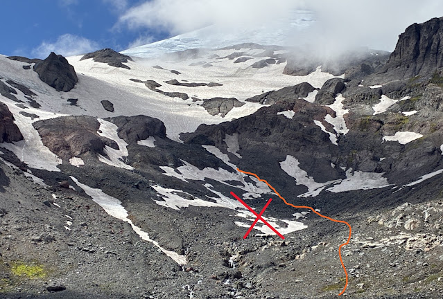
After leaving Glacier Basin, and following the trail up the Inter moraine, stay climber's right and avoid the lowest snow patches. The Inter Fork of the White River is flowing under these lingering snowfields and the risk of punching through the snow and getting swept away by the creek are not worth taking. Follow intermittent climber's trails over rocky slopes until you arrive at the toe of the Inter Glacier.
 |
| Recommended travel line shown climber's right of the Inter Fork of the White River . Avoid the snow slopes with running water underneath (denoted by the X) photo: 7/27/25 |
Travel up the Inter Glacier remains straightforward and efficient. Clean running water is plentiful and easy to find on the numerous exposed rock islands along the way. There are no open crevasses or exposed ice along the climber's trail up the Inter Glacier. The snow is firm, and some folks may prefer crampons for the ascent.
 |
| Inter Glacier travel is quite good for late July - 7/27/25 |
Camp Curtis to Camp Schurman
This section still requires some downclimbing over loose and somewhat steep terrain with poor footing in order to access the Emmons Glacier. A great description and good photos of this section can be found in the previous Emmons blog post. Once the downclimb is complete, rope up, and follow the obvious climbers trail to Camp Schurman.
Camp Schurman to Summit
From camp, follow the obvious boot tracks up towards the Emmons Flats. Climbers will encounter some sections of exposed glacier ice shortly after leaving camp. The boot pack fades away here, but the navigation is mostly straightforward with some traversing to end-run crevasses.
The established boot pack accesses the corridor higher than normal (an artifact from old ski tracks from early season). Rangers found a much better way to access the corridor on a solid snow bridge about 200' below the old trail.
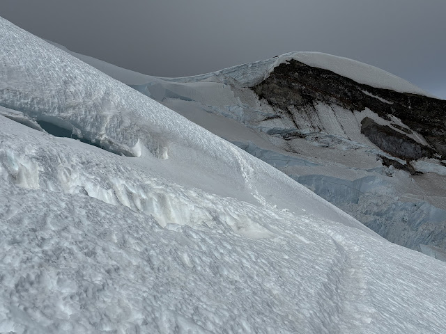
The corridor is sun-cupped and travel requires some French-technique with crampons to save energy. Near the top of the corridor, there are some crevasses popping out that will necessitate some back-and-forth traversing. When leaving the corridor, climbers will find some exposed glacier ice at the bridge that leads to the alpine meadow. This section requires some confident footwork with crampons.
 |
| Crevasses crossing near 13,300 ft (7/26/25) |
Above the corridor, the route still has good snow coverage. The penitentes cause the trail to be troughed in some sections, but good travel is found off trail in places. The route zig-zags around some large crevasses here. Most notably at 11,900 ft, 12,200 ft, and 12,300 ft. The snow bridge at 12,300 feet is not difficult to ascend or descend but warrants a belay to cross. Rangers found that the ability to quickly lengthen the rope interval between the lead climber and followers greatly aided belaying across this crevasse with a picket anchor; both for the ascent and descent.
 |
| A Ranger descends on belay across the snow bridge at 12,300 ft (7/26/25) |
 |
| The snow bridge over the 12,300 ft crevasse from above (7/26/25) |
At 13,200 ft, the route begins traversing towards Liberty Saddle. From Liberty Saddle at 13,600 ft, parties can choose to continue up mostly on snow to the crater rim, or travel up gravelly slopes from 13,900 to the summit.
 |
| The traverse to Liberty Saddle (7/26/25) |
Equipment
Because some sections of the route involve exposed glacial ice (albeit low angle) carrying a few ice screws is recommended to facilitate anchor building in these areas. The rest of the route is still snow, and picket anchors work very well. Parties should climb with a minimum of 4 pickets per group. Groups of 3 or more should carry at least 5 pickets. Every member of a climbing party should have the ability to build a snow anchor, and plunging an ice axe into the snow is not a viable plan. Ice axes with hammers are a good choice for the route in its current condition.
Permits and Planning
More information on climbing on Mt. Rainier can be found on the Mt. Rainier National Park Climbing Page. Here, you will find information about how to pay the Annual Climbing Fee, obtain a Climbing Permit, and make Reservations.
On behalf of the NPS climbing staff: happy climbing, and we hope to see you at high camp!

