Wednesday, May 28, 2025

Disappointment Cleaver 5/28/25


    After a busy Memorial Day weekend, climbers found a handful of days of favorable climbing weather and successful summits. After the serac fall from the upper Ingram Glacier on May 19, there have been no known climbing teams ascending the ID. All teams have been climbing the Disappointment Cleaver and holds the predominate track up the mountain for the Muir Corridor. 


DC and Ingraham Flats camp

    As for the route up the DC itself, it remains relatively unchanged from our previous blog post. Guide services have been putting in work widening and wanding the route over the past few days. With the increased climbing traffic helping to "punch in" the track, good cramponing and straightforward travel make for a fairly direct climb. There are still no ladders on the route at the time this blog is posted. A plethora of pickets above the cleaver to the summit remain as running protection options. Again, use at your discretion when deciding to clip into these. The NPS does not maintain these pickets and should be inspected by the climbing party for structural integrity in their placement.


Remaining Seracs from 5/19 collapse

    Teams are encouraged to move with purpose from Flats camp to the spine of the cleaver where the route is exposed to serac and rock fall. Please do not take breaks under the exposure on the ascent or descent. If there are other teams moving through this zone, communicate with each other to minimize traffic jams and bottlenecks where the overhead hazard is high.


Overhead serac exposure in the "Ice Box"


Additional Information

    A climbing permit and Payment of the Climbing Cost and Recovery Fee are required to climb Mount Rainier. More information can be found on Mount Rainier National Parks Website. The Paradise Wilderness Information Center (PWIC) is open for the season with hours of operation between 7:30am - 5pm


Emmons/Winthrop Route Update

 After a stormy Memorial Day weekend, the route remains in great shape for climbers.  The approach to Glacier Basin continues to melt out and there's more trail than snow now, and the snow patches that are present have a fairly consolidated boot pack for reasonable walking.  Be cautious on bridges where melting snow has created a potentially hazardous crossing.  See photo below for an example.  

Depending on the weather - the Inter Glacier can either be a skier's paradise, with over 3500 feet of planar snow at an average of 25 degrees, or a nightmare with the reflective heat of the sun roasting folks with huge packs trying to ascend or storm clouds reducing visibility to near zero with precipitation turning the snow to bottomless slush.  All of these conditions occurred during the last holiday weekend and it's worth noting that skiers will have to recognize when conditions are great for skiing or when it's dangerous to be travelling on skis through this terrain.  

The glaciers above high camp continue to offer many routes to the summit.  There's the classic route up the Emmons Corridor, crossing over to the Alpine Meadow and then traversing up and right to the summit, Columbia Crest.  An alternative route traverses right out of camp to the Winthrop Glacier, ascends a steep snow slope to the Winthrop Shoulder and then directly up the shoulder to the summit crater.  With guide services ascending the route for the first time this week, a boot pack should be established, but expect some route finding and keep a track log for your own navigation purposes.  Wands are not allowed to be left on this route - so any guide service or independent who places wands on their ascent will take them on their descent.  

Surface conditions above Camp Schurman continue to be transitioning from a "winter" snowpack to a more "spring" style snowpack.  This transition makes for breakable crusts, sastrugi, scoured icy sections and unconsolidated mush - challenging ski conditions - especially when considering the crevasse fall potential associated with skiing on the glaciers.  Look for the best skiing conditions lower on the mountain - the lower Cowlitz Glacier, Little Tahoma, the Inter Glacier and in the Tatoosh.  

Thursday, May 22, 2025

Emmons/Winthrop Route Update 5/22/2025

The road to the White River Campground and trailhead for Camp Schurman is slated to open Friday, May 23rd - just in time for Memorial Day Weekend.  Check the park's Road Status website for more details.  Rangers have opened up a toilet at Camp Schurman and there's also a barrel outside the toilet to deposit used blue bags.

Photo taken 5/21/25 of the Winthrop Shoulder.
The approach to Camp Schurman is still in early-season conditions and though there's a bit of snow right at the parking lot, expect the first mile or so to be bare trail.  The next couple miles will be a mix of snow and trail, and then almost 100% snow covered from the switchback a half-mile before Glacier Basin Campground.  The Inter Glacier has been planar and offered decent skiing conditions this spring.  

The climbing route above Camp Schurman has had only a couple of intrepid teams on it so far this year.  Expect no boot pack, nor wands on the route and winter-like conditions.  Wind transport of new snow has created some hollow sounding slabs and false bridges barely covering crevasses.  A team of experienced skiers who've skied this route in previously great conditions, found themselves taking off their skis multiple times and belaying across crevasse bridges and even a section of exposed hard glacial ice.  They also reported large sastrugi covering most of the upper mountain above the corridor.  They recommended giving the upper mountain a couple of weeks of melt/freeze before it's back into better skiing conditions.


Photo taken 5/21/25 of ice on the E/W Route.
Climbers can expect a less consolidated snow surface and more effort in "booting" up the route on the upper mountain.  Keep an eye on changing conditions as the weather changes into the weekend.  Teams should be more self-reliant during summit attempts this early in the season.  Don't rely on anyone else for rescue - make sure your team has what it needs if one of your party gets injured - think stove, extra fuel, sleeping bag, extra food, etc.  

Photo taken 5/21/25 of the large and firm sastrugi on the upper E/W route.
Skiers over on Little Tahoma reported great planar ski conditions on the Whitman and Fryingpan Glaciers.  No big crevasse openings yet on either of the glaciers and the snow has consolidated more at these lower elevations.  

No matter if you're planning on climbing or skiing this weekend, be sure to stay well within your ability level!  We hope to see you this holiday weekend - and many more holiday weekends in the future! 

Wednesday, May 21, 2025

Muir Corridor Update 5/21/25

Overview

The past week has brought high winds, new snow, and cold temps with varied forecast accuracy for the upper mountain. We observed winds in the 40-80+ mph, drifted snow on leeward regions totaling 24+ inches, and cold temperatures. Due to these conditions there has not been a high amount of traffic on the upper mountain, and teams can expect to encounter a more natural feel with less obvious boot pack in places, reinforcing the need for parties to always come prepared to use their own route-finding and navigational skills when climbing. Notable hazards right now include:

+White Out Conditions

+Serac Fall and Rock Fall

+Cold Temps

+Crevasse Fall

+Avalanche

Serac Fall at Ingraham Flats

At ~6am on May 19th a team staying at Ingraham flats reported a Serac Fall event that spread debris and ice blocks through portions of the Ingraham Direct route, within Flats Camp itself, and a few basketball sized ice blocks came to rest ~40ft downhill of camp. No one was harmed.

View from the flats, gouging on the Ingraham and blocks/debris visible (5/19, 11,000')

View of the debris from the cleaver, collapsed tents at the flats can be seen (5/20, 11,800')
Seracs at ~12,700ft on the Inghram Glacier, where the blocks originated (5/20, 12,300')

It's important to note that Seracs can fall at any time of day or night, regardless of forecasted temperature, wind events, or other factors. Forecasting when these chunks will fall is exceptionally hard if not impossible. Your best way to mitigate these hazards is to simply avoid them or minimize the time you are exposed to them. Be intentional where you take breaks, and move efficiently through zones where these objective hazards are present


Disappointment Cleaver

Route up the DC on 5/20/25

Cold temps, strong winds, and fresh snowfall this past week have helped keep the DC predominantly a snow climb, with a few short sections of rock to be encountered. Currently, the route is wanded to the summit. At ~13,700ft wands from the ID join the DC, and parties should take care to ensure they are descending their intended route. As of 5/20 there were fixed lines on the lower half of the cleaver, and many fixed pickets between ~12,500 and ~13,200.

There were no ladders present on 5/20. Teams are free to use fixed protection; however it may have been days since someone last checked or placed this gear and changing conditions may have compromised their security. Never clip into something you are not sure about and be prepared with your own kit to increase your security. As a reminder, the NPS does not place or maintain any of the fixed gear on the mountain.

Teams should consider shortening their rope length when moving through rocky areas, such as Cathedral Gap and on the cleaver, to prevent causing unnecessary rockfall that may threaten you or others. Teams are also encouraged to move with purpose from Flats camp onto the cleaver where the route is exposed to serac fall hazard from the upper Ingraham Glacier, and the Icebox climbers left of the cleaver. If there are other teams moving through this zone, communicate with each other to minimize traffic jams and bottlenecks where the overhead hazard is high. 

Looking up from Ingraham Flats Camp at the Disappointment Cleaver (5/19, 11,000')


The traverse getting onto the Cleaver (5/20, 11,400')

Switchback at the bottom of the Disappointment Cleaver with a fixed rope (5/20, 11,500')

Fixed ropes and mostly snow travel on the cleaver. (5/20, 11,500')

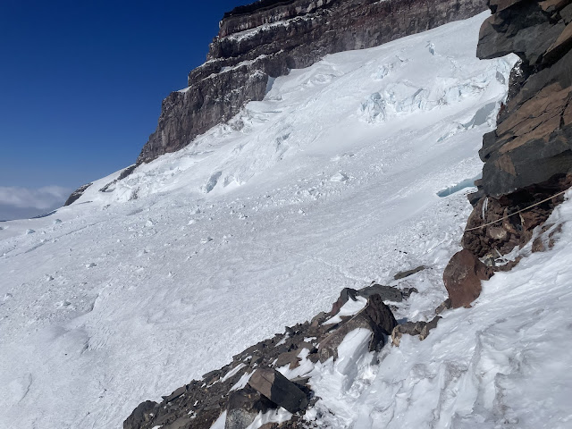
Looking up from the top of the cleaver at ~12,400'. The route trends climbers right above the cleaver around the seracs of the upper Ingraham glacier. (5/20, 12,300')

Looking out towards the Emmons Shoulder (5/20, 13,000')
.

Crevasse crossing near 13,400' with fresh snow bridging the crack. (5/20, 13,500')
.

There are several crevasses encountered near 13,500' on the upper DC route. Wind drifted snow has thinly covered many of these cracks and may hide the best place to cross. (5/20)


Ingraham Direct

Guided groups and independent teams alike have had success on the ID this season. Recently, all fixed protection has been removed from the route and most parties are opting to climb the DC due to recent serac fall on the route.


Route up the Ingraham Direct on 5/16/25

Between Ingraham Flats and 12,000ft there are a few crevasses that are beginning to open up and snow bridges that must be negotiated. Even with forecasted freezing levels this past week between 4,000ft and 6,000ft, the intense solar radiation and time with minimal or calm winds has meant that surface conditions began to soften and snow bridges were losing structure in the afternoon.

Looking up the Ingraham (5/16, ~11,200')

In the photo above, high on the Ingraham, center of the photo you can be see hanging seracs that threaten portions of the route from above. Already this season multiple parties have reported close calls and near misses with blocks falling near them when climbing the ID.

 ~12,000ft on the ID (5/16)

From 12k to Camp Comfort at just above 12,700ft the route is steeper, and more exposed. On 5/16 a handful of fixed pickets were present on the route protecting a few of these exposed traverses, and crevasse crossings. This pickets have since been removed so parties will need to come prepared to place protection for themselves and manage crossings like they would on any other route on Rainier.

Climbing Ranger Being Belayed Across a Bridged Crevasse at 12,700ft Utilizing Pickets for Protection on (5/16)

Above Camp Comfort the route trends left across the Nisqually glacier before switching back a few times to the crater rim. 

Additional Information 

A climbing Permit and Payment of the Climbing Cost Recovery Fee are required to climb Mount Rainier. More information can be found on Mount Rainier National Parks Website. The Paradise Wilderness Information Center (PWIC) is open for the season with hours of operation between 7:30am – 5pm.


Monday, May 12, 2025

Conditions Update 5/12/25

Ascending to Camp Muir is still mostly continuous snow with spots of rock beginning to show through. As snow melts, we ask that folks stick to wanded routes and snow surfaces to reduce impacts on vegetated terrain. As always it is encouraged to keep a track of your ascent route in the event that weather changes quickly - this will allow you to retrace your steps.  

Snowfield ascent to Muir 5/9/25

If climbing or skiing on a glacier or above 10,000 feet you need a permit (every time you come up to climb) and to pay the annual climbing fee (only once per calendar year). The PWIC (Paradise Information Center) is now open for the season at Paradise seven days a week 7:30 - 5:00. The White River Ranger station is still operating on a self-registration format. As always, climbers will need to pay the Annual Climbing Fee. More information can be found here

Climbing: Climbers have been ascending both the Ingraham Direct (ID) and Disappointment Cleaver (DC) route. Currently the DC has a few sections of rock and is predominantly still snow. Both the ID and DC routes had large sized serac fall cross the established routes. As always, limit time exposed to these hazards by moving efficiently and timing stops accordingly. 

Serac fall in the Ice Box on the Ingraham Glacier 5/10/25

Ingraham Flats with the DC and ID routes 5/10/25


Emmons/ Winthrop: 

The road to White River Campground and the trailhead to Glacier Basin is plowed but still closed to vehicles.  Some intrepid skiers have been biking from the North Park Boundary to the trailhead (11 miles) when the road is open to recreational use.  Be sure to note the sign on the gate as to whether the road is open to recreational-use or not.  There's still heavy equipment working and occasionally the road will close to bikers/hikers.  The trail from White River Campground to Glacier Basin is still mostly snow, but with long patches of dirt.  It's recommended to bring shoes/boots other than ski boots.  

Both the Emmons Moraine approach and Inter Glacier approach to Camp Schurman are in good shape.  Planar snow that's great for skiing can be found on both the Emmons and Inter. One bathroom is open at Camp Schurman and the blue bag barrel is open outside the bathroom.

The climbing route above Camp Schurman is in great shape, but untraveled.  Be prepared to be self-sufficient and find your own route up the glacier - there's no boot pack or wands to guide the way.  

Looking up the lower Emmons Glacier 5/9/25

Leave No Trace: Rangers have already noted human waste on climbing routes. Do your part and carry blue bags / wag bags on the mountain... and use them! Disposal of these can be done at both high camps, in barrels outside the bathrooms with flip lids. Additionally, for those that use the public shelter located at Camp Muir, remember to pack out what you have packed in - no trash left behind - even if you think someone might utilize it.

Weather: As Mount Rainier moves into summer weather we are continuing to see active weather patterns. Over the last few days, the Park has seen sun, rain and snow with winds ranging from calm to extreme speeds. Always do a thorough weather check before venturing onto the mountain and expect weather to change quickly. Be prepared for whiteout navigation with GPS tracks and mapping tools.  Also - remember that if you venture out in extreme weather any rescue resource may not be able to help you.  Helicopters cannot fly in clouds near the mountain and rescue crews will be delayed or unable to assist in extreme winds.  

Whiteout conditions on the Muir Snowfield 5/11/25