Tuesday, July 30, 2024

Emmons-Winthrop Route Update 7/30/2024


July 30th, 2024 

Overview:

Precipitation will be winding down today as a high pressure ridge enters the area. Freezing levels on the mountain will climb from 11,000 feet to 16,000 feet by mid-week and into the weekend. Check out the Mt. Rainier Recreational Forecast for more info.

The Emmons-Winthrop route remains climbable and the route conditions are average for this time of year. Some beautiful sunsets and sunrises have been occurring and Camp Schurman has been a wonderful place to watch these last couple of weeks.  In general, it continues to be an all time year to climb the Emmons-Winthrop.  A true joy.  With weather transitioning to sunny and hot, the route will continue to change and so will the hazards:

+Thin/weak snow bridges over crevasses
+Changing route
+Warm temperatures/dehydration
 
The Emmons Glacier and Little Tahoma from the east


Emmons-Winthrop Route:
 

From White River: 

The trail is snow free to the base of the Inter Glacier. Climbing conditions on the Inter remain straightforward. Crevasses will continue to open around convexities with the forecast warm temperatures. Use caution if glissading. There's some steep icy pitches that end on rock islands.  Don't glissade in crampons.  

Camp Curtis to Camp Schurman: 

The transition from the dirt trail below Camp Curtis to the Emmons glacier has been giving some parties difficulty. The trail begins adjacent to the numbered sites at Camp Curtis. 

Accessing the glacier requires a 50-foot scramble down a loose gully (Class 2-3). Wearing crampons for this section may give some climbers more secure footing; make your own assessment.

Once below the downclimb, rope up before walking to Camp Schurman. This route from Camp Curtis onto the Emmons remains the preferred route and is easier than any alternative.

 
The scramble transition from Camp Curtis to the Emmons Glacier


Upper Mountain: 

The route above Camp Schurman is a tale of two boot packs - one is well defined, and the other is more recent and difficult to see. Climbers will need to leave the old boot back frequently to ascend the upper mountain. From Camp Schurman, follow the well-defined foot path up the Corridor. A few crevasses are opening up along the corridor with punchy snow bridges when the snow softens. 

At 11,500 feet, just above the corridor are two large crevasse crossings. The snow bridges spanning these crevasses are narrow and may require the use of snow anchors to belay climbers as they cross. A fall while crossing either of these bridges (or plugs) will not be held by team arrest. 


The first of two large crevasse crossing at 11,500 ft


The first crevasse crossing at 11,500 feet is simple and ample space exists above and below for snow anchors. The second crevasse crossing is more difficult to negotiate. The trail is narrow, exposed, and the bridge is showing signs of weakness. Using a belay here is recommended-especially on the descent. A rope interval of 35 feet between climbers is enough to span these crevasse crossings. Some parties have elected to turn around here.

 
The first of two large crevasse crossing at 11,500 ft (from uphill looking down)


Alpine Meadow: 

From the 11,500 ft crossings, the boot pack ascends straight up for a few hundred feet before making an ascending traverse to climbers right. Along this traverse, climbers will need to follow variations to the old boot pack to find intact snow bridges to cross several crevasses. A few wands exist in this area marking the better crossings but evaluate each one as conditions change. These crossings are easy to miss on the descent. 


Winthrop Shoulder:

The route makes switchbacks up the shoulder from 12,200 feet to 13,000 feet. Through this section, climbers will have to leave the defined boot back several times to find intact snow bridges to cross crevasses. The snow texture is ankle high sun cups that soften nicely after sunrise. At 13,000 feet, the well-defined boot pack begins traversing climber’s right towards Liberty Saddle.

The boot pack from 13,000 ft toward Liberty Saddle


Liberty Saddle to the Crater Rim:

Just below the saddle, the route end runs a large crevasse far to climber’s right. A half dozen crevasses can be end run by zig-zagging the low angle terrain. At 13,900 feet, traversing climber’s left above a large crevasse for about 500 feet will provide easier walking to the crater rim and will avoid the large penitentes just north of Columbia Crest. 
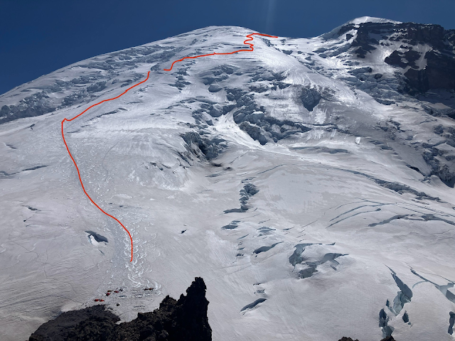

The Emmons-Winthrop route as of 7/30/2024


Risk Management and Time Management: 

The Emmons-Winthrop route is not easier than the Disappointment Cleaver route - and requires different skills. It requires a route-finding skillset and the ability to belay climbers and construct solid snow anchors. Crossing crevasses while temperatures are lower before sunrise will mitigate some risks. However, the route may be difficult to navigate in the dark. Dehydration is a major concern going into this weekend, and parties will need to manage time efficiently to avoid a long and hot descent. 


Early morning light from the top of the Corridor, looking SE


Additional Information 

- Check out the Emmons-Winthrop Route Brief for more information about climbing this route. 

- Some parties have discovered recently that the ski season is over on the route above Camp Schurman. Snow conditions are most conducive to climbing with mountaineering boots. 

- Equipment: a shovel is necessary for a flat tent platform at Camp Schurman. A couple ice screws may be a good addition to your team's crevasse rescue kit.

- Climbers can pick up their climbing permit at the White River Wilderness Information Center which is open 7:30 am to 5:00 pm daily, (phone: 360-569-6670). Blue bags can be gathered here. Please climb with blue bags. 

-Climbing permits may be obtained 24 hours in advance of the trip. Consider getting your permit the day before your trip to allow your party to get a pre-dawn start from White River. With the very warm weather expected this weekend, climbing while its cool will make the trip more enjoyable.

Monday, July 29, 2024

Leave No Trace on Rainier 7/29/2024


This blog is maintained by the Climbing Ranger team for use by recreational non-guided climbers. Use these reports as a baseline, but plan for changing conditions.

Leave No Trace on Rainier

Leave No Trace (LNT) is a term many backpackers and climbers are familiar with. This set of seven principles people follow in the backcountry to leave where they go looking as untouched as possible so that future generations can enjoy the same wilderness experience. A number of the principles also relate to your personal safety and will help you enjoy your experience in the wilderness.

From the impacts we have been seeing in Mount Rainier National Park it seems that some of these principles have been forgotten. Here's a rundown of how to apply the seven principles on Rainier and other alpine areas.

1. Plan Ahead and Prepare
Do your research on the route, climbing permits, and climbing fees a head of time.
Know and practice your skills before you get on the mountain (from your layering system to navigating in whiteouts to crevasse rescue), skills are perishable.
Use some form of GPS for route finding on mountain.
Know the gear you need and how to use it.
Be self-sufficient and prepared when you come on Rainier so you can prevent an incident. If things do go south, have the skills and equipment to care for yourself and teammates so you don't pull other people into your incident and endanger them.

2. Hike and Camp on Durable Surfaces
When climbing Rainier, most camp locations will have parties camped out on the most durable surface, snow. If you are lower on the mountain, camp only in preestablished sites and do not improve or invent any new sites.

3. Dispose of Your Waste Appropriately
Pack it in and then pack it out. Food scraps, empty fuel cannisters, water bottles, dental floss, used toilet paper and poop (to name a few), are commonly picked up at high camps. It does NOT biodegrade up high in the snow and will be sitting there for years to come. Rangers work hard to keep the mountain clean, but we need your help! Please pack down everything you've brought up with you.

Trash collected out of the public shelter at Camp Muir on 7/27/24


Human waste: You can't dig a cat-hole and bury it in a glacier and expect it to disappear forever. It will likely melt out later in the summer, or the following years. We have thousands of climbers on Rainier every year, imagine how the mountain would look (and smell) if folks didn't use our toilets or pack out their human waste!

Bring your blue bag / wag-bag and bring extra so that you have enough. Blue bags can be acquired at the Wilderness Information Center for free when you pick up your permit. Camp Muir and Camp Schurman have blue bag barrels where you can dispose of your blue bags for proper processing. 
Hole at Ingraham Flats full of human waste and toilet paper that rangers have to clean up.


4. Take Nothing but Pictures
Snap a photo of the awesome things you see so that you can remember them later. Leave all flowers, rocks, and other natural things alone. Don't feed or try to pet wildlife. Ravens and rodents are prevalent in high camps. Properly secure food and scented items.

5. Minimize your campfire impacts
This one is simple in the alpine. No fires are allowed in the alpine, and wood is kind of hard to come by.
What would Smokey Bear do? 

7. Respect Other Visitors
Watch out for bottle necks on routes- try to space yourself out from other parties when leaving camp on busy nights. Be careful when traveling on loose rock (keep your rope short) so you don't knock rocks off onto other people or knock rocks onto yourselves.


Please, help us keep our mountains looking pristine to provide an awesome climbing experience for all to have!

Kautz Glacier Conditions Report 7/27/24


July 28th, 2024


This blog is maintained by the Mount Rainier National Park Climbing Ranger team for use by recreational non-guided climbers. Use these reports as a baseline, but plan for changing conditions.


In recent weeks Mt Rainier has had overcast skies and slightly lower than average temperatures followed by clear skies and near normal temperatures. Snow levels are at about 7,600 feet and the wildflowers are in full effect in the subalpine meadows. There have been a few fires to the east and to the north, yet the air quality and upper mountain views have remained relatively clear. The main hazards that climbers should consider include:

+Ice fall under seracs and rock fall

+Crevasse fall due to thin snow bridges

+Dehydration

Kautz Glacier Route


The approach to the Kautz Glacier route via Commet Falls trailhead is free of snow up to the Turtle Snowfield at about 7,000 feet. At this time hikers will see numerous wildflowers including lupine, paintbrush, avalanche lilies and pasqueflowers. Please avoid the temptation to pick the flowers and only take photos. The approach via the Lower Nisqually to the Wilson Bench is heavily crevassed but passable at this time.


Approach track via Commet Falls Trailhead


Campsites at both upper and lower Castle Camp (9,200 feet and 9,400 feet) are snow free with running water near by. The upper bivies between 10,800 and 11,200 feet are also snow free. Please make use of existing tent platforms and avoid creating new sites when possible.

 
An example of a Kautz Route track


The rock step at the start of the Kautz climb is still currently filled in making for a small move down onto the snow. There is an existing anchor and fixed rope here. Be sure to inspect for yourself if choosing to use this for security. The ice chute has one mandatory ice step at the very base. This portion is about 50 feet long. Options for additional pitches of ice exist to the climbers right of the steeped snow in the center of the chute. The remaining snow is heavily sun affected and has formed into buckets and steps.

 
Lower ice chute displaying the ice step


Once past the ice chute, navigating both the upper Kautz Glacier and the Upper Nisqually involve crossing a series of snow bridges and moving over penitentes. These are snow “spikes” which form at high altitudes and are the result of radiation and sublimation of the snow. Consider adjusting your estimated travel times as these features reduce the speed of travel somewhat.

 
Wapowety Cleaver looking across the upper Nisqually


For specifics on the Kautz Glacier route please reference the NPS route briefing packet- Kautz Glacier Guide. Climer registration can be done at either the Longmire Wilderness Information Center or the Paradise Wilderness Information Center. Both are open from 7:30 am- 5:00pm daily. “Blue bags,” or human waste bags, can be found here. Please carry all waste off the mountain. Be sure to check out at after finishing your climb. Lastly remember to pay for an annual climbing cost recovery fee.


Sunday, July 28, 2024

Disappointment Cleaver Update 7/28


This blog is maintained by the Climbing Ranger team for use by recreational non-guided climbers. Use these reports as a baseline, but plan for changing conditions.

Overview

The guided route up the Disappointment Cleaver continues to change. The guide services worked all day yesterday to establish a route that goes through to the summit without traversing below and through the recent ice fall on the Ingraham Glacier. The route currently travels straight up from the Cleaver. There is a handline through a steep pitch of snow. Expect this section to change rapidly and potentially require a ladder soon. After the handline parties will encounter steep ladders at 12,800' and 13,200'. As is always the case, inspect these pieces before using them and expect rapid change as the snow melts throughout the day. We are continuing to see warmer than average temperatures on the mountain.

Takeaways

With warmer temperatures we are seeing increased rockfall, icefall and weakened snow bridges. If you plan to attempt a summit climb, returning back to terrain with minimal overhead hazard by 10am is advised. Substantial delays and bottlenecks were observed today at the adjunct locations, these slowed climbers down by over an hour. Additionally, climbers reported watching ice fall occur near these ladders.


Double Ladder at 13,200'


Multiple Parties waiting at the 13,200' Ladder


Bottom line, the DC is in a slightly more "technical" state than normal. Independent climbers should be prepared to utilize their ropes, pickets, prussiks, etc. for belay, ascension, and descension on the more challenging sections. Climbers should also be prepared to coordinate with other teams to manage the potential for bottlenecking on route. Please be prepared to assess the quality of all fixed gear, ropes, and ladders. Do not remove any equipment found on route. For a broad overview on the traditional climbing route, please reference the NPS route briefing packet- Disappointment Cleaver- Ingraham Direct

Saturday, July 27, 2024

Disappointment Cleaver Update 7/27

This blog is maintained by the Climbing Ranger team for use by recreational non-guided climbers. Use these reports as a baseline, but plan for changing conditions.

July 27, 2024

In the last 24 hours the guided route above the Disappointment Cleaver was taken out by major Ice fall on the Ingraham Glacier. Due to the severe overhead hazard of house sized serac blocks the guides are no longer traversing from the top of the Cleaver toward Camp Comfort. 

Large Icefall on the Upper Ingraham which took out the Guided route above the Cleaver.

There is currently no guide established route. Guides are working hard at this time to establish a new route. 

Friday, July 26, 2024

Disappointment Cleaver Update 7/26/24

 July 26, 2024

This blog is maintained by the Climbing Ranger team for use by recreational non-guided climbers. Use these reports as a baseline, but plan for changing conditions.

Overview

Winter of 2024 brought slightly warmer than average temperatures, resulting in average seasonable snowfall on the upper and mid mountain. Below ~5000ft, snow totals were below average. Currently the snow line is at about 7000 - 7500 feet. Summer is here on Mount Rainier and freezing levels have been at or above the summit for the last 3 weeks. Crevasses are opening up and the route has seen some significant variations compared to years past. Many teams have been reaching the summit with the current established routes. Some of the hazards associated with higher temperatures include:

               + Rock fall/Icefall

               + Crevasse Bridge Collapse

               +Dehydration and Heat Illness


Muir Route

The path to Camp Muir up the Muir Snowfield currently follows the standard summer trail. Please pay special attention to trail markings and stay on the trail as the local alpine meadows are fragile and unique. Above Pebble Creek the route is mostly snow covered to Camp Muir

Disappointment Cleaver

The route to Ingraham Flats from Camp Muir takes the standard route. It is well marked and boot packed. Climbers should be prepared to shorten their rope spacing after getting off the Cowlitz Glacier and before crossing Cathedral Gap. This will reduce risk of crossing ropes with other teams and  knocking loose rocks onto climbers below.

The route above Ingraham Flats currently ascends the Disappointment Cleaver to its top. The path is clear of any major cracks and gaining the Cleaver is straightforward. On the Cleaver, teams should be prepared to shorten rope spacing and get the rope off the ground to minimize rock fall hazard on climbers below. The Cleaver is approximately 25% snow covered, with intermittent patches remaining throughout the ridge. 

From the top of the Cleaver, only one established route currently goes to the summit. This route is marked in the map below. A previous variation, noted as the "red variation" in the 7/20/24 post, has seen critical ladder crossings fall out of condition. While it is possible that this section will get reestablished, it is not currently climbable.


Track from Rangers climbing on 7/20/24

The current route requires one to travel climbers right off the top of the Cleaver along a wanded boot pack under a large serac. This is followed by a few sections of fixed pickets, ladders, and ropes. At ~13,000', the route downshifts in technical difficulty and becomes similar to more typical DC conditions with a well-established, wanded boot pack to the summit. It is possible that recent high winds have knocked over some wands up high. Climbers should have confidence in navigating the upper portion of the route without the common wanded handrail. It is worth noting on this route that there is no getting around accepting the hazards associated with traveling under a serac.

 The top of the Cleaver is a few hundred feet up and climbers right of where this image was taken. From there, climbers are traveling through the terrain below the well-defined serac on the horizon line of this image. Evidence of a serac avalanche that occurred in early June can be seen in this image.

Bottom line, the DC is in a slightly more "technical" state than normal.  Independent climbers should be prepared to utilize their ropes, pickets, prussiks, etc. for belay, ascension, and descension on the more challenging sections. Climbers should also be prepared to coordinate with other teams to manage the potential for bottle necking on route. Please be prepared to assess the quality of all fixed gear, ropes, and ladders. Do not remove any equipment found on route. For a broad overview on the traditional climbing route, please reference the NPS route briefing packet- Disappointment Cleaver- Ingraham Direct

The Paradise Wilderness Information Center (PWIC) is open daily from 07:30-17:00. Check in here before your climb to receive your permit, to check for walk up availability, and pick up "Blue Bags" for human waste. You will also check out at the PWIC at the end of trip.  Lastly, please remember to pay the Annual Climbing Cost Recovery Fee

We look forward to seeing you in the hills!


Sunday, July 21, 2024

Disappointment Cleaver Update

July 21, 2024

This blog is maintained by the Climbing Ranger team for use by recreational non-guided climbers. Use these reports as a baseline, but plan for changing conditions.

Overview

Winter of 2024 brought slightly warmer than average temperatures, resulting in average seasonable snowfall on the upper and mid mountain. Below ~5000ft, snow totals were below average. Currently the snow line is at about 7500 feet. Summer is here on Mount Rainier and freezing levels have been at or above the summit for the last 3 weeks. Crevasses are opening up and the route has seen some significant variations compared to years past. Many teams have been reaching the summit with the current established routes. Some of the hazards associated with higher temperatures include:

               + Rock fall/Icefall

               + Crevasse Bridge Collapse

               +Dehydration and Heat Illness


Muir Route

The path to Camp Muir up the Muir Snowfield currently follows the standard summer trail. Please pay special attention to trail markings and stay on the trail as the local alpine meadows are fragile and unique. Above Pebble Creek the route is mostly snow covered to Camp Muir

Disappointment Cleaver

The route to Ingraham Flats from Camp Muir takes the standard route. It is well marked and boot packed. Climbers should be prepared to shorten their rope spacing after getting off the Cowlitz Glacier and before crossing Cathedral Gap. This will reduce risk of tangling ropes with other teams and minimize the risk of knocking rocks loose onto teams below.

The route above Ingraham Flats currently ascends the Disappointment Cleaver to ~12000ft. The path is clear of any major cracks and gaining the Cleaver is straightforward. On the Cleaver, teams should be prepared to shorten rope spacing and get the rope off the ground to minimize rock fall hazard on climbers below. The Cleaver is approximately 25% snow covered, with intermittent patches remaining throughout the ridge. 

At ~12000ft, two route variation exist. These route variations both involve ladders and utilization of fixed protection and ropes. These adjuncts are maintained by the guide services. While adjuncts do see consistent maintenance, changing daily conditions regularly affect the quality of anchors. Recreational climbers should be prepared to evaluate the condition of all fixed ladders, ropes, and protection. Each variation presents its own challenges and hazards. The variations are marked in red and blue on the topo below.

Track from Rangers climbing on 7/20/24

The "red variation" involves ladders and fixed ropes that travel through a ~50 meter section of ~55 degree terrain. Climbers should be prepared to manage a "pitch" of technical climbing on both the climb and descent for this variation. This section also represents a potential "bottle neck" where climbing can slow down as multiple parties queue up behind one another. Climbers would be wise to coordinate with other teams prior to climbing to manage too many parties stacking up in this section at once. Otherwise, the climbing below and above the bottle neck is well established and straightforward climbing. 

The "red variation". This travels to the indistinct gulley in the center of the horizon line. The gulley is detailed in the image below.

The crux of the red variation. The ladder marks the start of the fixed lines. The fixed lines travel through the right leaning snow/ice ramp and end at a fixed anchor on the ridge.

The blue variation involves less difficult climbing but has a few sections of ladders and fixed lines to manage. It also travels under a large serac for a period of time. Travel on this variation is quicker and less prone to the bottle neck issues of the red variation. However, one must accept the hazards associated with traveling under a serac. From the top of the Cleaver, one will find wands and an impacted path traveling climbers right toward the serac in the image below.

The "blue variation" as seen from below. The top of the Cleaver is a few hundred feet up and climbers right of where this image was taken. From there, climbers are traveling through the terrain below the well-defined serac on the horizon line of this image. Evidence of a serac avalanche that occurred in early June can be seen in this image.

Each variation presents its own challenges. Both routes converge at ~13000ft. The conditions have not slowed down the guide services and most independent teams are successfully managing the current conditions. Bottom line, the DC is in a slightly more "technical" state than normal.  Independent climbers should be prepared to utilize their ropes, pickets, prussiks, etc. for belay, ascension, and descension on the more challenging sections. Climbers should also be prepared to coordinate with other teams to manage the potential for bottle necking on route. Please leave all fixed gear, ropes, and ladders in place. For specifics on the climbing route please reference the NPS route briefing packet- Disappointment Cleaver- Ingraham Direct


The Paradise Wilderness Information Center (PWIC) is open daily from 07:30-17:00. Check in here before your climb to receive your permit, or to check for walk up availability and be sure to check out here at the end of trip. "Blue Bags" used for human waste can be picked up here. Also please remember to pay the Annual Climbing Cost Recovery Fee.


Sunday, July 14, 2024

Emmons Update 7/13/24

July 14th, 2024

This blog is maintained by the Mount Rainier National Park Climbing Ranger team for use by recreational non-guided climbers. Use these reports as a baseline, but plan for changing conditions.

During the month of July, Mt Rainier has been experiencing clear sunny weather with above average temperatures and freezing levels between 14,000-15,500 feet. Current hazards include:

+Thin Snow Bridges and Crevasse Falls

+Knee Strain/Strain and Lower Leg punctures by Crampon Points due to Soft Snow

+Dehydration


The approach to Glacier Basin is currently snow free and the Inter Glacier is still holding winter snow. When dropping from Camp Curtis to get on to the Emmons Glacier, be sure to rope up for glacier travel. Rangers have observed teams traveling this section to Camp Schurman without a rope, particularly when descending from camp. There are numerous large crevasses in this section.


Image of climbers traveling without a rope in use on the Lower Emmons approaching Camp Schurman.

The route has continued to follow the same path as the last week or two. Some things to consider are that with warm temperatures snow bridges have been continuing to thin. The existing "trail" goes over thin portions of numerous snow bridges which were robust a week ago, and are now beginning to sag, which is an early sign of impending collapse. Use discretion when crossing and do not hesitate to go off the boot pack to cross a thicker portion of the snow bridge.


Route as scene from Camp Shurman. Note yellow line indicating the 11,400 foot "plug" detailed bellow.

At least one snow bridge crossing should require additional attention at this time. This is the 11,400 foot "plug". It is a major bridge roughly the width of a dump truck and if it were to fail with a climber on it there is possibility for a major swing into the adjacent wall. Additionally, this crossing is long enough that more than one climber at a time could end up on it, both increasing the likelihood of collapse, and making a team arrest more difficult. Consider adding security when crossing this, particularly on the descent. 


Side profile of the snow bridge at 11,400 feet. This image demonstrates the length; the width is about as wide as a dump truck. Use additional caution when crossing this. Or considering finding an alternative work around.

Please be sure to climb with "blue bags" on route. These can be disposed of at Camp Schurman at the designated barrel by the doors to the entrance of the restrooms. These can be picked up at the White River Wilderness Information Center (open every day from 7:30 am to 5:00 pm), the same location as where climbers pick up their climbing permits. Also, when there be sure to observe the printed-out photo of where tent platforms are allowed next to camp Schurman. For more information about climbing the Emmons route consult the Emmons-Winthrop Route Brief. Remember to pay for you annual climber's recovery free, found here.


Thursday, July 11, 2024

Trash, Waste, and Leave No Trace! Cleaning Up Muir and a DC Update!

With the increased numbers of visitors utilizing Camp Muir as summer takes off, rangers have been finding more and more trash around Camp Muir that isn't being managed properly. No trash removal is provided by the park service at any of the high camps. All trash must be hiked out. Unfortunately, people are increasingly leaving trash hidden or stuffed in corners around camp, in the bathrooms, hidden in the snow, and piled in the public shelter. This is starting to have a significant impact on camps, as it is attracting mice. The public shelter is the publics' shelter. Not the rangers' or guide services.' This means it is a shared resource. A resource every user is responsible for. People all too often convince themselves that leaving their half-eaten Mountain House or fuel canister is "helpful." But soon, every other climber does the same, and a mound of trash is left behind. Please be mindful of this and hike out all of your trash. Help manage the shelter by hiking out any other trash you may find. Leave the shelter like you would want to find it when you first arrive. 

When it comes to human waste, more is also emerging on route and around camps. Please utilize the bathrooms around camp and the blue waste bags for disposal on route. Remember to carry them with you back to camp. The blue bags are provided by the ranger stations if you forgot to bring any. Don't leave them on route with the expectation they will be there on the descent. They will blow away and can become an unpleasant object to have fall down the mountain. The park service does provide disposal at the high camps for the blue bags. There will be marked barrels near the bathrooms. If you are unsure of where to dispose of them, please ask! Don't stuff them into the toilet systems, which may break the system, or hide them around camp. Several unsavory discoveries have been made.

DC Route Update:

The heatwave over the past week brought freezing levels up to 17,000' at times, with little to no radiative cooling and strong winds. Most climbers are shifting start times earlier in order to climb through the night so they are done by the time the sun and heat hits the route. This helps minimize exposure to rockfall and crevasse crossing hazards. The loss of snowpack means the Cleaver is now largely rock until the upper portion. Travel carefully and short rope through this section to help minimize knocking down loose rock. 

As of Sunday the 7th, the route from the top of the Cleaver continues up a steep traverse where there are handlines and fixed pickets for running protection. Remember that these pickets need to be checked before use as the warm temps have melted them out. The route then arrives at a series of switchbacks before the route continues up two vertical ladders to make it up a large step around 13,200'. 

We have received multiple reports since yesterday (7/10) that a large crevasse collapsed around 12,800' where the switchbacks started. This occurred sometime in the afternoon and a party descending late in the day was trapped above for a short time before being forced to rappel into the crevasse and climb out the bottom. This serves as a reminder that parties need to be prepared to route-find, safely utilize technical climbing skills, and potentially climb back up and then descend alternative routes. Multiple guide parties are currently working to establish a reroute around this new feature as it has stopped multiple parties who have been unable to find a route around. Please be respectful of these parties as they work.  

Additional Notes:

Please remember that the DC route is popular, but it is still a technical, high-altitude mountaineering route that requires skilled use of alpine climbing and glacier travel techniques and equipment. Many parties are climbing with the expectation of somebody being nearby to quickly provide assistance and are projecting their risk onto others without consideration. If you can't fully manage your own risk, consider shifting to another objective on Rainier or in the Cascades to build those skills. With the current reroute underway, these skills are even more important, as you may have to do your own route-finding. The ability of your party to be self-sufficient is imperative for a safe and successful mission.

Thursday, July 04, 2024

Emmons-Winthrop Update 7/4/24

The Emmons-Winthrop route currently follows the standard path up out of Camp Schurman.  Small cracks have opened up low on the route and the first major crevasse crossing is around 11,400 ft. There's two options to cross this crevasse - one option is going straight up over a narrow snowbridge or working climber's left and end-running the crack. As of the day this blog is written, the snow bridge here remains and has been the option used the most. After the anticipated heat-wave however, this option might fall through, forcing climbers to go left.  Many are opting to place fall-protection to navigate this section, especially on the descent.


Route as seen from Camp Schurman

The route then continues with several long, right-hand traverses to avoid large crevasses. The last long right-hand traverse is at 13,400 ft. to end run the bergschrund and get to Liberty Saddle. It is within this zone the route travels directly under large seracs immediately above. Move efficiently and do not take breaks under this, or any, overhead hazard. Surface conditions have been decent overall but expect a wide variety of soft, firm, wind-board, and so forth throughout the entirety of the route.


Overhead serac hazard around 13k

Worth noting that the heat wave forecasted is expected to put freezing levels at 16000ft +. Many days of this heat has historically taken a large toll on the entirety of the mountain. Seracs, snowbridges, rocks, crevasse openings, wet-loose avalanches, and more can all be potential hazards worth heavily reiterating as the mountain melts during this heat wave.

Skiers: See our recent post about Ski-Mo or Ski-No

Skier numbers on the upper mountain have been dwindling drastically as the upper slopes do not offer very good snow conditions for skiing. There are large open crevasses that would be extremely dangerous in the event of a fall on skis in the wrong spot. The few parties that have brought skis have been opting to leave them at the top of the Corridor, at around 11,400 feet, and continue to the summit on foot.

Additional Information  

It is strongly recommended that parties rope up if ascending or descending from Camp Schurman via the lower Emmons. There is a large crevasse complex just below camp that you have to cross. It is opening quickly, and bridges are getting thinner every day. 

It is worth reiterating from the last post to never abandon your climbing partners on the upper mountain. NEVER split up. If you are climbing, stay together, roped up. If you are skiing, stay close enough to see each other and spot each other. 

Proper food and blue bag storage is still very important. Rangers have found multiple wag/blue bags at the Emmons Flats Camp that were left out and compromised by the ravens. They will get into waste and food if not stored properly. Please practice Leave No Trace!

Lastly, if you haven't seen a new blog post for a while, that likely means not much has changed on the route! See you on the mountain!


DC Route Update 7/4/24

July 4th, 2024

This blog is maintained by the Climbing Ranger team for use by recreational non-guided climbers. Use these reports as a baseline, but plan for changing conditions.

Overview

Winter of 2024 brought slightly warmer than average temperatures, resulting in average seasonable snowfall on the upper and mid mountain, with the lower mountain below average. Currently the snow line is at about 5,500 feet. Summer is here on Mount Rainier and temps have been back to average, with above average temperature forecasted for the week ahead. Crevasses are beginning to open up, but the climbing route is well established. Many teams have been reaching the summit by this point. Some of the hazards associated with higher temperatures include:

               + Rock fall/Icefall

               + Crevasse Bridge Collapse

               +Dehydration


Muir Route

The path to Camp Muir up the Muir Snowfield currently follows the summer trail which is mostly snow free. Please pay special attention to trail markings and keep to the trail as we would like hikers and climbers to avoid trampling sensitive vegetation. Above Pebble Creek the route is snow covered.

Above Camp Muir the route has seen significant traffic, and the path is well marked and packed in. Climbers should be prepared to shorten their rope spacing after getting off the Cowlitz Glacier and before crossing Cathedral Gap, in order to reduce risk of tangling ropes with other teams and to minimize the risk of knocking rocks loose onto teams below.


View of Ingraham Flats after rounding the corner of Cathedral Gap. Disappointment Cleaver is visible about the tents


The route above Ingraham Flats currently ascends the Disappointment Cleaver. The path is clear of any major cracks and gaining the Cleaver is straightforward. Here too, teams should be ready to shorten rope spacing. The Cleaver is approximately 50% covered in snow, and it is expected to melt out after this weekend's heatwave. Pay special attention for red flagged wands which mark the way here, as there are many old trails, some which may lead to dead ends.

The route above the Cleaver steepens as it ascends and switchbacks and has a handful of "fixed" snow pickets with webbing runners and carabiners attached. Please leave this gear for other teams to use. This gear is intended for clipping into and use as a running belay, meaning that rope team members continue to move in unison. Beyond the steep switchbacks with running protection, teams will encounter two ladders at 13,200 feet. Both options are viable, there are two ladders to reduce bottlenecking at this point. Note that there are fixed snow pickets in place that attach to the ladders, and some that are free. These free pickets both below and above the ladders are intended for rope teams to clip into and use as running protection. As always, be sure to evaluate any fixed gear as they are checked by guides when passing, but are subject to melting out. For specifics on the climbing route please reference the NPS route briefing packet- Disappointment Cleaver- Ingraham Direct


Image of the ladders crossing at 13,200 feet. Note the open pickets at the base of the ladders, these are intended to be used as running protection

This portion of the route from 12,500-13,300 feet where the fixed adjuncts are in place is where bottlenecking is most likely to occur. If teams are backed up here it is advised to wait down below, or above in order to reduce teams lining up in this tight space and exposing climbers to ice fall and crevasse fall hazard. Beyond this portion the route is mostly direct to the crater rim. When descending from the summit consider spacing out from other teams to reduce the potential for backups here.


View as seen from the top of Disappointment Clever. Note the steep switchback in the center of the photo above the team of climbers. Also, the ladders are faintly visible to center right at the upper most crack in the photo. This is where bottlenecking has been occurring, and the exposure to risks is best mitigated by spacing out rope teams to minimize time in this zone.


As always, don't just follow the boot pack blindly toward the summit.  Look both climber's left and right for other options to ascend the mountain - even if the boot pack doesn't lead there.  There are always multiple ways to climb Mount Rainier - just be sure to stay within your team's ability level and place fall-protection if things get steep!  

The Paradise Wilderness Information Center (PWIC) is open daily from 07:30-17:00. Check in here before your climb to receive your permit, or to check for walk up availability and be sure to check out here at the end of trip. "Blue Bags" used for human waste can be picked up here. Also please remember to pay the Annual Climbing Cost Recovery Fee.